
Geo-Social Influence Spanning: Why Your Social Marketing Needs a Map
Geo-Social Influence Spanning Maximization
This paper introduces the Geo-Social Influence Spanning Maximization (MGSR) problem, which aims to select k seed nodes that maximize the geographical coverage (spanning region) within a target area while ensuring a minimum regional acceptance rate. The authors propose the OIR*-Tree, a hybrid spatial-social index, and an incremental algorithm that significantly outperforms traditional greedy influence maximization baselines.
TL;DR
Most social influence strategies are obsessed with how many people you reach. This paper argues that where they are is just as important. The authors introduce the Maximum Geographic Spanning Regions (MGSR) problem—a way to find influential users who can spread a message across the widest possible area within a specific region. By leveraging a new hybrid index called the OIR-Tree*, they achieved performance gains of up to 175x over standard greedy algorithms.
Motivation: The "Clustering" Pitfall
Imagine you are organizing a city-wide marathon in Melbourne. If you only target the most influential social media users, you might find that all of them live in the same high-density neighborhood. Your marketing creates a "hotspot" in one suburb while the rest of the city hears nothing.
Existing Location-aware Influence Maximization (LIM) models attempt to solve this by filtering users within a region, but they still aim for the maximum count of users. They don't care if those users are all standing on the same street corner. The MGSR problem bridges this gap by treating geographical "span" as a first-class citizen in the optimization equation.
Methodology: The Core Innovations
1. The Bi-Criteria Objective
The paper defines a new scoring function that balances two metrics:
- Geographic Span: The percentage of geographic grids covered.
- User Coverage: The number of nodes influenced within those grids.
The key constraint is the Regional Acceptance Rate (): a sub-region is only "counted" if at least of its users are activated. This prevents "thin" influence where a region is touched but not truly engaged.
2. The OIR*-Tree Index
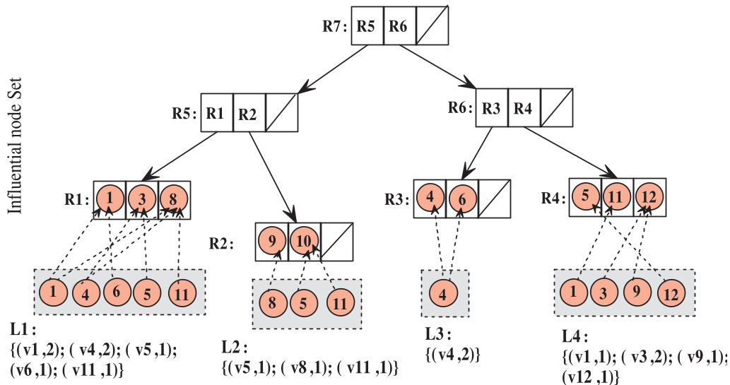
To solve this NP-hard problem at scale, the authors move beyond simple greedy searches. They propose the OIR-Tree*, a hybrid structure that merges:
- R-Tree*: For spatial pruning of users and regions.
- Ordered Influential Lists: Pre-computed lists of how much "activation power" a node holds over specific spatial segments.
3. Bottom-Up Verification
Instead of checking individual users, the algorithm checks sub-regions. It uses a bottom-up strategy to identify "(r, k)-satisfactory" regions—areas where seeds can achieve the threshold. This "Result Reuse" prevents the repeated, expensive computation of influence propagation across the whole graph.
Experimental Breakthroughs
The authors tested their methods on Gowalla, Twitter, and Foursquare datasets.
Efficiency: Scaling to Big Data
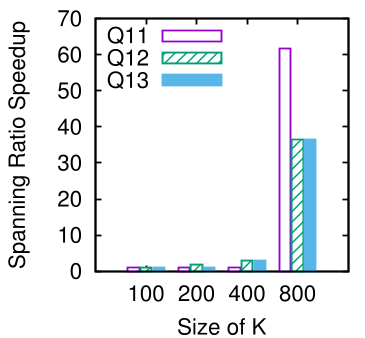
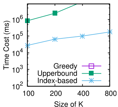
On the Foursquare dataset (4.9M nodes, 53.7M edges), a standard greedy approach took 22 hours for a single query. The OIR*-Tree index-based solution finished in just 27 seconds.
Effectiveness: Better Spatial Distribution
The paper introduced a "Spatial Reachability" metric. If most activated users are within each other's "social radius," the influence is too clustered. MGSR reduced this clustering ratio significantly (e.g., from 50% down to 14% on Foursquare), proving it selects a much more diverse and representative set of seeds.
Critical Insight: The Value of Spatially-Aware Influence
This research highlights a critical shift in social network analysis: Geography is a proxy for diversity. By forcing the model to span a geographic region, we implicitly force it to cross different social communities that might not be connected in the digital graph.
Limitations:
- The model assumes a static social graph, whereas real-world influence often changes with user movement and time.
- The grid-based discretization, while efficient, may introduce edge effects at the boundaries of sub-regions.
Conclusion
The MGSR problem and the OIR*-Tree index provide a robust framework for marketers and urban planners to maximize their "footprint" rather than just their "likes." As social networks become increasingly tied to physical locations through "check-ins" and IoT, hybrid index structures like this will become the backbone of real-time geo-marketing systems.