
Geo-Social Interaction: Leveraging Social Graphs for Precision Help in Large-Scale Spaces
Geo-Social Interaction: Context-Aware Help in Large Scale Public Spaces
This paper presents a "Geo-Social Interaction" framework for optimized information dissemination in large-scale public spaces, specifically vehicular networks. It introduces an improved relevance backpropagation mechanism governed by a Geo-Social Relevance (GSR) function to identify the most appropriate help providers based on spatio-temporal and social contexts.
TL;DR
In a world of hyper-mobility, getting help is no longer just about "who is closest," but "who is closest AND can actually help." This paper introduces a Geo-Social Relevance (GSR) framework that optimizes how "Help-Me" requests are routed in vehicular networks. By marrying social network analysis (FOAF) with real-time spatio-temporal tracking, the authors cut network congestion by 50% while improving the quality and trustworthiness of the help provided.
Context and Motivation
Large-scale public environments, particularly Vehicular Ad-Hoc Networks (VANETs), are notoriously difficult for information exchange. Objects move fast, connections are transient, and requests are often time-critical. The authors identify a gap in current SOTA methods: conventional broadcasting creates massive "noise" (redundant packets), and simple location-based routing ignores the expertise or trustworthiness of the recipient.
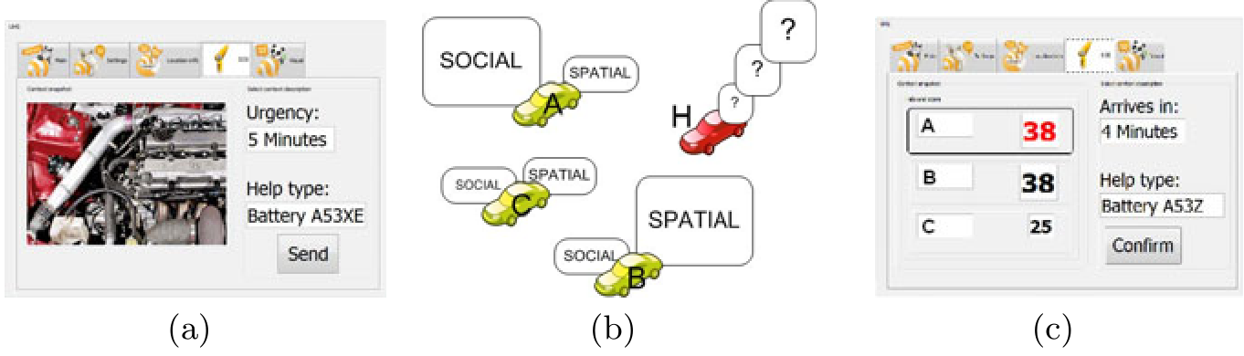
The insight here is the "Three-Leaved Mirror":
- Social Leaf: Who do you know (or who do your friends know)?
- Spatial Leaf: Where are they, and are they moving toward you?
- Central Leaf: How do we optimize the network flow using the above two?
Methodology: The Geo-Social Relevance (GSR) Function
The heart of the paper is a mathematical scoring function that determines the "Fittest Assistant."
The GSR Formula
The score for a potential provider is defined as:
- A (Availability): A binary gatekeeper.
- R (Reliability): A peer-voted trust score (1-10).
- HT (Help-Type): Technical compatibility (e.g., does the provider have the tools to fix a flat tire?).
- n (Hops): Trust decays as the social distance increases (modeled by the nth root).
- F_U (Spatio-temporal factor): A complex calculation involving the "Urgency" of the seeker and the "Velocity" and "Direction" of the provider.
The function intelligently balances social parameters and spatial closeness. For distant nodes, social trust takes a back seat to proximity, but as nodes get closer, the specific social expertise becomes the deciding factor.
Simulation and Experimental Setup
The authors didn't just test this on a handful of nodes. They used the OMNeT++ simulator with a massive dataset involving 260,000 vehicles over 24 hours.
They compared three strategies:
- Broadcasting: The "shout to everyone" baseline.
- Simple Backpropagation: Filtering based on basic context.
- Improved Geo-Social Backpropagation: The proposed method using the GSR function.
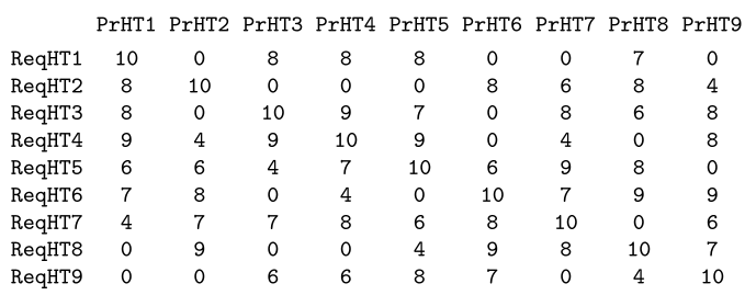 Table: The asymmetric "Help-Type" matrix, recognizing that expertise is rarely bidirectional.
Critical Results: Efficiency Meets Quality
The results confirm the intuition that "smarter" routing leads to a cleaner network.
- Traffic Reduction: The GSR-based approach used 50% less traffic than broadcasting.
- Relevancy & Trust: Because the algorithm selects for "Help-Type" match and social reliability, the "Quality of Information" (QoI) scores were significantly higher.
- Dynamic Learning: The system extends "friend lists" asymmetrically—if a stranger helps you once, they are added to your social network, improving future routing efficiency.
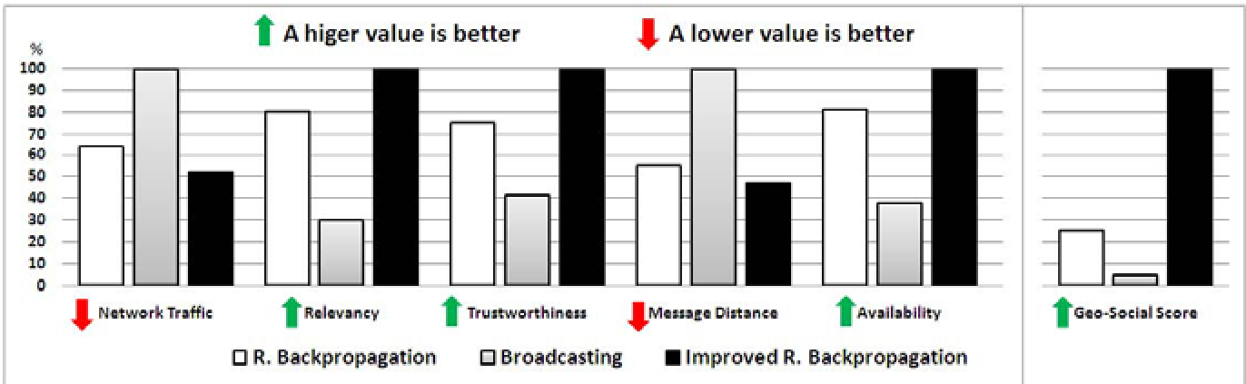 Chart: The improved algorithm (column 1 in the plots) consistently outperforms broadcasting and simple backpropagation across Network Traffic, Trustworthiness, and Availability.
Critical Analysis & Conclusion
While the results are impressive, the paper operates under a few optimistic assumptions, such as available GPS precision and pre-defined social hierarchies. However, the contribution is significant: it proves that social graphs (FOAF) can serve as a robust filtering layer for physical ad-hoc networks.
Future Outlook: This work lays the groundwork for "Social VANETs." Beyond cars, this logic is highly applicable to crowdsourced delivery systems or emergency response apps in dense urban areas, where the "Expertise/Location" overlap is the most valuable commodity.
Takeaway: In complex public systems, the most efficient route isn't always a straight line; it's the one that passes through the most qualified friend.