
GeoCrowd: Bridging the Gap Between Digital Crowdsourcing and Physical Mobility
GeoCrowd: enabling query answering with spatial crowdsourcing
GeoCrowd is a pioneering framework for spatial crowdsourcing that assigns location-based tasks to mobile workers. It introduces the Maximum Task Assignment (MTA) problem and proposes three algorithmic strategies (GR, LLEP, and NNP) to optimize task allocation in a server-assigned task (SAT) mode.
TL;DR
GeoCrowd is the first comprehensive framework to treat humans as mobile sensors in a unified, multi-campaign architecture. By redefining task assignment as a Maximum Flow problem, the paper provides a scalable way to assign physical tasks (like taking photos or reporting traffic) to mobile users while optimizing for either maximum completion rates or minimum travel exhaustion.
Academic Standing: This is a seminal work in the field of Spatial Crowdsourcing, establishing the core taxonomy (SAT vs. WST) used in hundreds of subsequent papers in SIGSPATIAL and VLDB.
The "Spatial" Challenge: Why Mechanical Turk Isn't Enough
In standard crowdsourcing, a worker in London can label an image for a requester in New York instantly. In Spatial Crowdsourcing, the "cost" is physical. A worker cannot perform a task unless they are at a specific coordinate within a specific time window.
Prior works focused on "Participatory Sensing"—specific apps for traffic or weather. GeoCrowd's insight is that we need a Generic SC-Server (Spatial Crowdsourcing Server) that acts as a broker for any type of spatial task, balancing the constraints of thousands of workers simultaneously.
Methodology: Flow Networks and Entropy
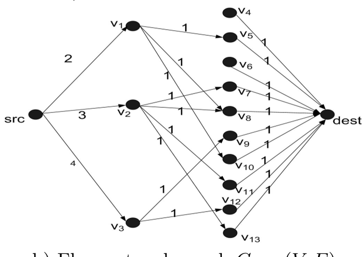
The authors solve the Maximum Task Assignment (MTA) problem by reducing it to a Flow Network.
1. The Core Graph Architecture
The server constructs a graph where:
- Source connects to Workers (capacity = max tasks the worker can do).
- Workers connect to Tasks (if the task is within the worker's specified spatial region ).
- Tasks connect to Sink (capacity = 1 for single assignment).
2. Strategic Heuristics: LLEP & NNP
The local greedy choice (assigning any available task) is sub-optimal. The authors propose:
- Least Location Entropy Priority (LLEP): This uses the physics of "crowd movement." If a task is in a popular area (High Entropy), many workers will pass by later. If it's in a remote area (Low Entropy), we must assign it now to the current worker because no one else might ever go there.
- Nearest Neighbor Priority (NNP): Uses Euclidean distance as a "cost" in a Minimum-Cost Maximum Flow algorithm to ensure workers aren't sent across the city unnecessarily.
Experiments and Results
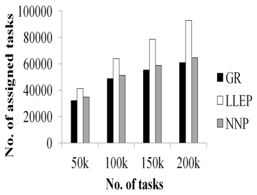
The authors tested their algorithms using Gowalla check-in data (a real-world location-based social network) and synthetic models.
- Task Throughput: LLEP consistently outperformed basic greedy strategies, increasing assigned tasks by 30-36%. This proves that understanding worker distribution (entropy) is more vital than simple matching.
- Travel Efficiency: NNP reduced the average distance workers had to travel by 41-45%, which is critical for worker retention in real-world applications.
Critical Insight & Future Outlook
The beauty of GeoCrowd lies in its abstraction. By treating task assignment as a flow problem, it benefits from decades of optimization research. However, the paper identifies a major friction point: Privacy. For the SAT mode to work, workers must share their exact locations with a central server.
Future Directions:
- Privacy-Preserving SC: Using Differential Privacy or Cloaking to hide worker locations while still allowing for effective flow assignment.
- Dynamic Incentives: Moving from "self-incentivized" (volunteers) to "reward-based" systems where the server dynamically adjusts pay based on task entropy.
Conclusion: GeoCrowd transitioned the field from "sensing apps" to "spatial platforms," providing the algorithmic backbone for the gig-economy-style sensing we see in modern smart city initiatives.