
GeoSDFA: Bridging Social Dynamics and Geographic Routing in Urban Vehicle Networks
Geographic Routing Based on Social Dynamic Features Aware in Vehicle Social Network
This paper introduces GeoSDFA, a geographic multicast routing protocol for Vehicular Ad-hoc Networks (VANETs). It utilizes social dynamic features—macroscopic traffic flow, microscopic movement entropy, and contact strength—to optimize message delivery in large-scale urban environments.
TL;DR
In the sprawling complexity of urban Vehicular Ad-Hoc Networks (VANETs), traditional routing often fails due to intermittent connectivity and the "Delay Tolerant" nature of the environment. This paper presents GeoSDFA (Geographic routing based on Social Dynamic Features Aware), an algorithm that moves beyond simple mobility patterns. By analyzing macroscopic traffic flows and individual microscopic "social" habits of vehicles, it achieves higher delivery rates and lower overhead than previous SOTA methods like GeoMob.
The "Blind Spot" of Mobility-Aware Routing
Current geographic routing protocols often treat vehicles as random moving particles or follow rigid traffic flow probabilities. This leads to two major issues:
- Strict Path Adherence: Methods like GeoMob only value vehicles on a mathematically "optimal" path, ignoring nodes that frequently visit the destination via "side streets" or irregular schedules.
- Network Congestion: Without a sophisticated cache scheduling mechanism based on delivery utility, buffers overflow and delivery rates plummet as traffic increases.
The authors' core insight is that vehicles are driven by humans, making their movement trajectories a reflection of social behavior. If we can capture both the "macro" (city-wide traffic) and the "micro" (individual driver habits), we can find better relays for information.
Methodology: From Entropy to Contact Strength
GeoSDFA operates on three distinct layers of perception:
1. Macro-Social Dynamics
The city is modeled as a weighted directed graph where nodes are geographical areas and edges represent traffic volume. This provides a baseline for finding the most connected regions.
 Figure 1: Visualizing macroscopic traffic density helps identify high-connectivity zones.
2. Micro-Social Dynamics
The movement of a single vehicle is not purely random. The authors use nth-order conditional probabilities (Equation 1) to predict where a vehicle will go next based on its history. They found that taxi movement entropy is higher during the day, indicating high activity but structured behavior.
3. Contact Strength (The "Shortcut" Factor)
This is the "secret sauce." Even if a vehicle isn't on the standard shortest path, if it spends a lot of time in the target destination area (), it is a prime candidate for a relay.
```text
// Simplified Likelihood Logic
If (Target Area is in vehicle's future path) {
    Likelihood = High (based on distance to target)
} Else {
    Likelihood = Probabilistic (based on nth-order movement patterns)
}
```
Experimental Results: Real-World Evidence
The authors tested GeoSDFA against GeoMob, GeoProphet, and GeoEpidemic using a massive dataset of 2,299 Shanghai taxis.
Peak Performance
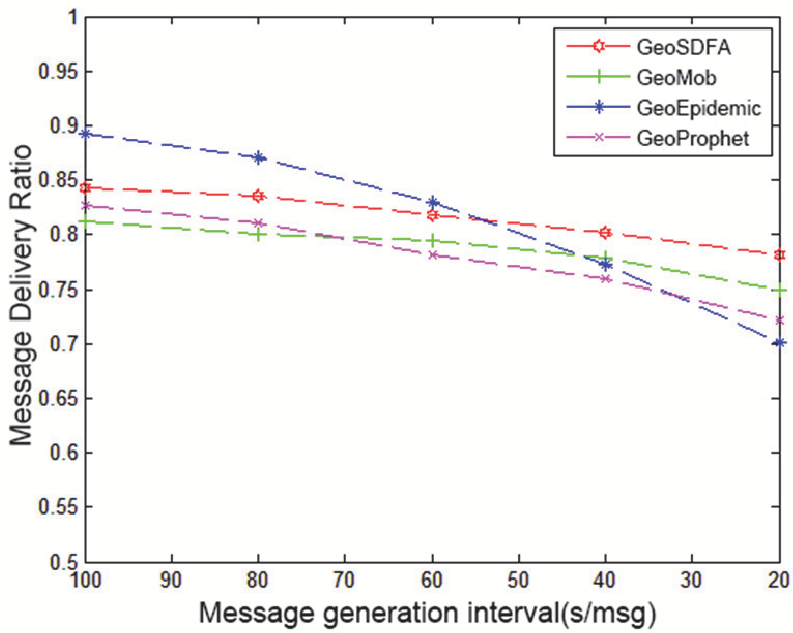
In dense message scenarios (low generation intervals), GeoSDFA consistently outperformed competitors in Delivery Rate. While GeoEpidemic's performance collapses under the weight of excessive packet duplication, GeoSDFA remains stable.
Efficiency and Latency
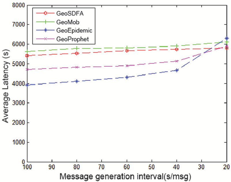
By prioritizing packets via Likelihood and Contact Strength, the network overhead is drastically reduced. Furthermore, leveraging vehicles that have a high "affinity" for the destination reduces the average delay because messages spent less time idling in the buffers of "lost" vehicles.
Critical Analysis & Conclusion
GeoSDFA proves that social context is a powerful inductive bias for network routing. By viewing a vehicle not just as a coordinate but as an entity with a "social destination," the protocol avoids the local optima that trap traditional geographic algorithms.
Limitations:
- The current model assumes cooperative nodes. In the real world, "selfish" nodes might refuse to relay messages to save battery or bandwidth.
- At very low message generation rates, the overhead of maintenance might slightly increase latency compared to simpler "flood-based" methods.
Future Outlook: The next frontier for this research involves integrating Incentive Mechanisms (to combat node selfishness) and exploring how these social dynamics change with the advent of Autonomous Vehicles, where "social" patterns might shift from human whims to algorithmic optimization.