
Mining the Pulse of the City: Scalable Co-location Patterns in Geosocial Data
Co-location Pattern Mining of Geosocial Data to Characterize Urban Functional Spaces
This paper presents a scalable approach for Spatial Co-location Pattern (SCP) mining using geosocial Points-of-Interest (POI) data to characterize urban functional spaces. It introduces an optimized parallel/distributed SCP mining algorithm implemented on Hadoop MapReduce, demonstrated through a comprehensive case study of Berlin, Germany.
TL;DR
Researchers have developed an optimized, distributed mining algorithm using Hadoop MapReduce to uncover how different activities (like shopping, working, and dining) cluster together in major cities. By analyzing Facebook POI data in Berlin, the study successfully mapped urban "functional spaces," revealing how city centers differ from peripheral boroughs through the lens of spatial co-location.
Problem & Motivation: The Complexity of Urban Dynamics
As urban populations swell, understanding the "functional morphology" of cities—how different areas serve different social and economic needs—is critical. Points-of-Interest (POI) data from social platforms offer a goldmine of information, but they present a massive computational challenge.
Traditional spatial mining algorithms often collapse under the weight of combinatorial explosion: the number of potential co-location patterns grows exponentially with the number of POI categories. Furthermore, existing distributed frameworks frequently ignore edge cases, such as "empty neighborhoods" in sparse areas, which can break the iterative logic of pattern discovery. The authors sought to bridge the gap between Big Data engineering and Urban Geography.
Methodology: Optimizing the MapReduce Pipeline
The core of the research lies in an optimized Parallel Co-located Event Set Search. The process involves:
- Spatial Partitioning: Dividing the city into manageable grids to find neighboring pairs.
- Participation Index (PI): A metric used to ensure a pattern is truly "prevalent" and not just a result of one ubiquitous feature (like a specific brand of store).
- Algorithmic Refinement: The authors modified the "Pattern Search Mapper" (as seen in Figure 2) to handle empty neighborhood instances, ensuring that the iterative search for larger patterns (k+1) remains robust across varied urban densities.
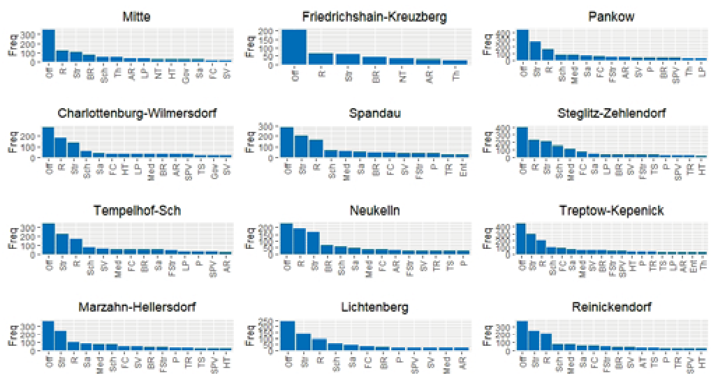 Figure 2: The generalized and optimized pattern search procedure designed for Hadoop.
Experiments & Results: The Anatomy of Berlin
The researchers applied their methodology to ~14,000 Facebook POIs in Berlin. By setting neighborhood distance thresholds (d) at 500m and 1000m, they uncovered the city's functional DNA:
- The Core (Mitte, Friedrichshain-Kreuzberg): Dominated by entertainment and culture, showing high co-locations of {Art, Restaurant, Bars}.
- The Periphery: Characterized by administrative and logistical clusters, specifically {Office, Store, Restaurant}.
- Specialized Hubs: Marzahn-Hellersdorf stood out with a unique co-location of Medical Health facilities and Offices.
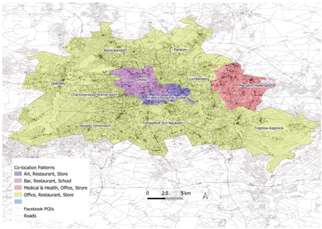 Fig. 3: Spatial distribution of the most prevalent size-3 co-location patterns across Berlin's municipal boroughs.
From a performance standpoint, the implementation proved efficient. As shown in the study's quantitative results, even as pattern sizes and data volume increased, the MapReduce framework maintained a manageable execution time, outperforming previous baseline implementations when scaled.
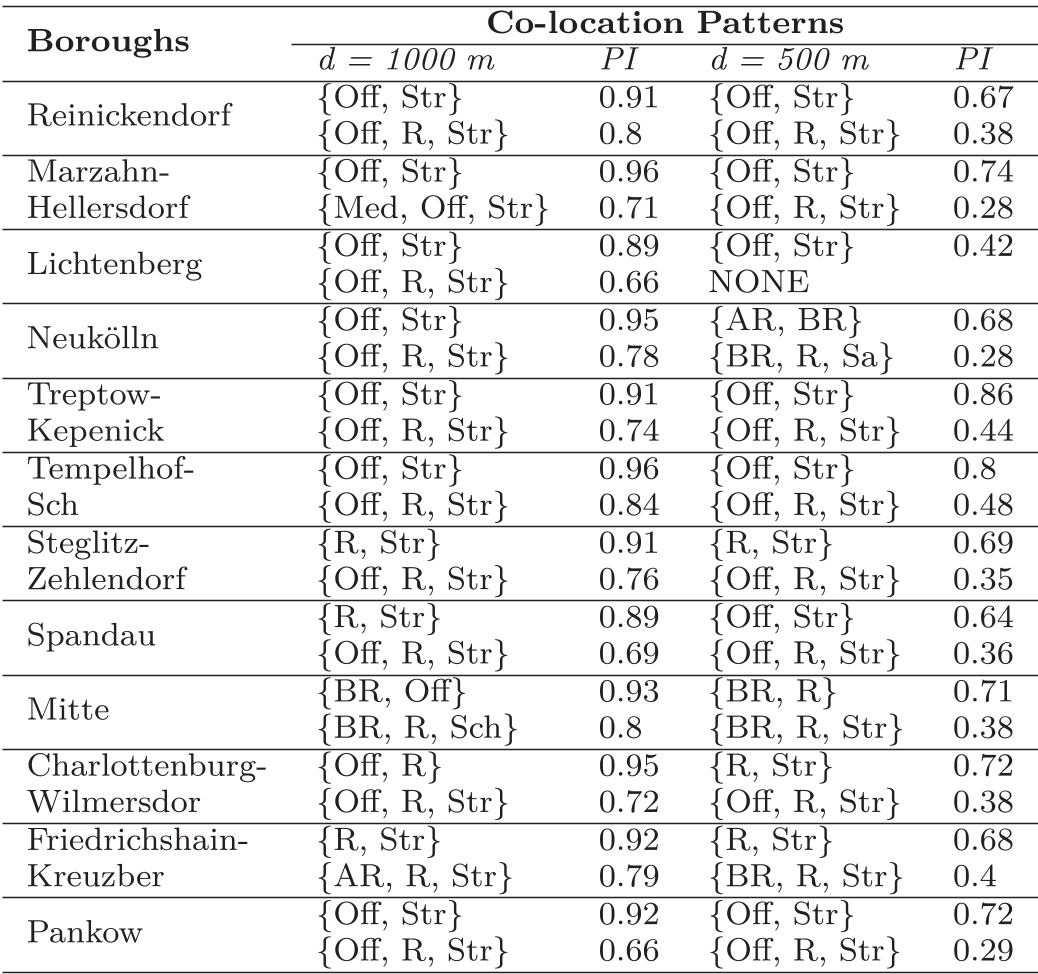 Table 2: Comparison of prevalent patterns across boroughs under different spatial scales (500m vs 1000m).
Critical Insight & Conclusion
The significance of this work extends beyond just "finding clusters." It validates that crowd-sourced geosocial data is a reliable proxy for traditional urban geography models. By proving that an optimized MapReduce approach can handle the scale of a major metropolis like Berlin, the authors have paved the way for global-scale urban functional analysis.
Limitations: While effective, the reliance on Facebook API data may introduce demographic bias (skewing towards users of the platform). Future work integrating multiple data sources (e.g., OpenStreetMap, transit data) would likely provide an even more granular view of urban life. However, as it stands, this research is a "first of its kind" in using distributed computing to decode the functional complexity of massive urban POI networks.