
GeoTeGra: Unveiling Hidden Semantic Connections in Urban Big Data via CapsGraph
GeoTeGra: A System for the Creation of Knowledge Graph Based on Social Network Data with Geographical and Temporal Information
GeoTeGra is a scalable, parallel framework designed to construct and analyze Heterogeneous Information Networks (HIN) by fusing multi-source social, spatial, and trajectory data. It introduces "CapsGraph," a novel graph embedding method leveraging Capsule Networks to find semantic similarities between entities across diverse datasets.
TL;DR
GeoTeGra is a sophisticated parallel processing system that bridges the gap between disparate data worlds: social media (Twitter), spatial infrastructure (OpenStreetMap), and human mobility (Taxi trajectories). By introducing CapsGraph, a Capsule Network-based embedding technique, the system can identify deep semantic similarities between entities across these heterogeneous domains, providing a unified "hyper-dataset" for urban intelligence.
Problem & Motivation: The Silo Effect in Big Data
We live in an era of data abundance, yet our insights remain fragmented. A tweet might tell us what people are saying, a taxi trip shows where they are moving, and a map shows what is physically there. However, treating these as isolated streams limits our understanding.
The authors identify a critical gap: existing systems lack a scalable way to fuse these heterogeneous networks while capturing the complex, hierarchical relationships between entities. Traditional node embedding methods (like Node2Vec or DeepWalk) rely heavily on local connectivity but often fail to capture the "part-whole" relationships essential for semantic reasoning across different domains.
Methodology: The GeoTeGra Engine and CapsGraph
The GeoTeGra architecture is built for scale, utilizing a distributed MapReduce framework and an RDF triple store. The workflow follows a clean pipeline: Data Ingestion Semantic Conversion (RDF) Vectorization Clustering/Embedding 3D Visualization.
The Core Innovation: CapsGraph
While many systems use standard Graph Neural Networks, GeoTeGra introduces CapsGraph. Unlike standard neurons that output a scalar value, CapsGraph uses "Capsules"—vectors that represent the properties of an entity.
- Feature Representation: Nodes are represented using multi-dimensional vectors where TF-IDF weights are applied to structural features like in-degree and out-degree of neighbors.
- Dynamic Routing: It employs Hinton's dynamic routing mechanism. When the predictions of adjacent nodes agree, they activate a higher-level capsule. This allows the model to learn "parts" of a social/spatial pattern and recognize the "whole" context.
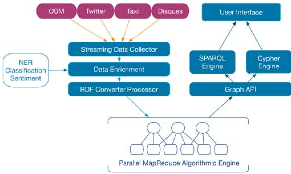 Figure 1: The GeoTeGra Framework Overview, showing the pipeline from heterogeneous sources to the machine learning engine.
Experiments & Results: Cross-Domain Fusion in Action
The system was tested using three massive datasets:
- Twitter: Extracting social context via geotagged tweets.
- NYC Taxi Data: Using DBSCAN to cluster trajectories into meaningful mobility patterns.
- OpenStreetMap (OSM): Providing the "ground truth" for spatial semantics.
Performance and Comparison
The authors compared CapsGraph against the widely used Node2Vec. While Node2Vec is efficient for structural similarity, CapsGraph showed a superior ability to cluster nodes based on semantic interactions across the HIN. The system provides a 3D temporal-layered visualization that allows users to see how connections evolve over different time windows.
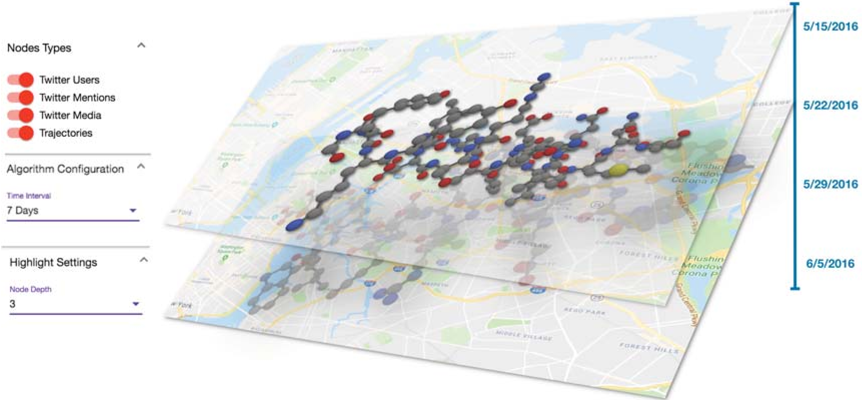 Figure 2: The cross-domain knowledge fusion system visualizing similarity patterns in a 3D environment.
Critical Analysis & Conclusion
Takeaways
GeoTeGra successfully demonstrates that the Inductive Bias of Capsule Networks—specifically their ability to model hierarchical relationships—is highly effective for graph data. By moving beyond simple random walks, we can find similarities between a "Twitter user," a "POI on a map," and a "Taxi drop-off point" in a unified semantic space.
Limitations & Future Work
While the system is powerful, the reliance on manual configuration for temporal windows () might be a bottleneck. Future iterations could benefit from Automated Machine Learning (AutoML) to dynamically determine the optimal window size. Additionally, while the system is scalable via MapReduce, moving towards a real-time streaming architecture (like Apache Flink) could reduce the latency from "Near Real-Time" to truly instantaneous.
Ultimately, GeoTeGra represents a significant step toward "City Brain" architectures, offering clear value for urban planning, targeted logistics, and proactive traffic management.