
Digital Neighborhoods: Why Online Social Networks Still Obey Physical Laws
Geovisualising Unequal Spatial Distribution of Online Social Network Connections: A Hungarian Example A ´kos Jakobi and Bala ´zs Lengyel
This study investigates the spatial topology of the Hungarian Online Social Network (OSN) "iWiW" through advanced geovisualization. By analyzing 785 million friendship ties, the researchers demonstrate that virtual connections are deeply anchored in physical geography, exhibiting a "small-world" pattern heavily influenced by settlement size and proximity.
TL;DR
Despite the promise of a "borderless" internet, your digital social circle is likely much closer to home than you think. Using a massive dataset from the Hungarian OSN iWiW, researchers have mapped nearly 800 million connections to prove that physical distance and geographic barriers (like mountains) are still the primary architects of our virtual lives.
The "Death of Distance" is a Myth
For decades, technologists argued that Information and Communication Technology (ICT) would make geography irrelevant. However, this paper argues the opposite: Online Social Networks (OSNs) are essentially "biased versions of real-life networks." Most people use platforms not to meet strangers, but to articulate existing offline relationships.
The core problem addressed here is spatial inequality. Not every city is connected equally, and the "virtual space" is heavily warped by the "physical world."
Methodology: Beyond Simple Connection Counts
If you simply map the number of connections between cities, you’ll just see a map of population centers (e.g., the busiest link is between Budapest and Debrecen). To see the real social fabric, the authors use the Log-Likelihood Ratio (LLR):
This formula compares the observed connections between two towns against what you would expect by random chance. Positive values indicate a social bond that is stronger than the town's size would suggest.
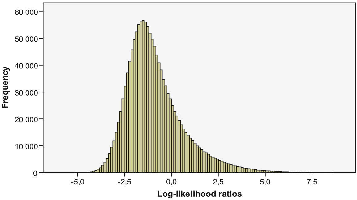 Figure: The process of transforming point-based user data into a filtered line-based network topology.
Visualizing the Digital Divide
The study’s geovisualization reveals three critical insights:
- The Small-World Effect: Most connections are local (intra-city loops account for ~370 million ties).
- The Mountain Barrier: One of the most striking findings is the visualization of the Börzsöny mountains. Even though users could technically befriend anyone, the map shows that ties rarely cross the mountain range, preferring to stay on the same side of the slope—mirroring real-world transport and commuting routes.
- The Hub-and-Spoke Model: While small villages have high relative connectivity (strong local bonds), large cities act as the global hubs that prevent the network from fragmenting.
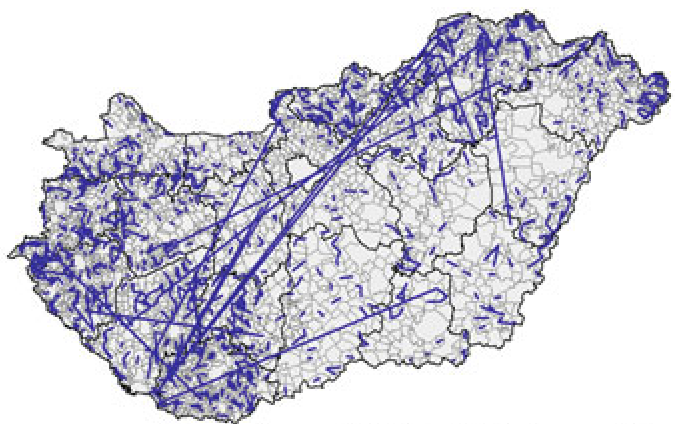 Figure: Mapping the strongest LLR weights shows how small, neighboring settlements form tight-knit digital clusters.
Regional Dynamics: Aggregating the Data
By moving from individual towns to NUTS-2 and NUTS-3 regional levels, the authors generated "heatmaps" of social activity. They found that:
- User Density: Larger cities don't just have more users; they have a higher percentage of the population online.
- Connection Distance: People in central hubs (like Budapest) have a much higher "Average Relative Distance" for their friends compared to those in peripheral villages.
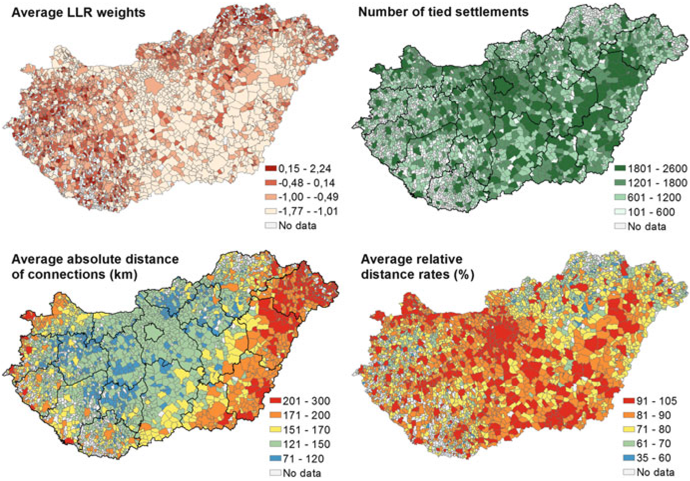 Figure: Comparison of average LLR weights, connection counts, and relative distances across Hungary.
Critical Insight: Why This Matters
This research is a "reality check" for the digital age. It proves that cyberplace is not a separate dimension; it is a layer draped over our physical landscape. For policymakers and urban planners, this means that digital connectivity cannot solve social isolation if physical infrastructure (like roads or regional hubs) is lacking.
Limitations: The study uses data from iWiW (a stagnating platform compared to Facebook). Future work would benefit from comparing these "legacy" networks with more mobile-centric, globalized platforms to see if the "Mountain Barrier" effect is finally beginning to erode.