
GPS-Denied Navigation: Solving Trajectory Errors via SAR Image Distortion Learning
Gps-Denied Navigation Using Sar Images And Neural Networks
This paper introduces a novel approach for GPS-denied navigation by using Convolutional Neural Networks (CNNs) to estimate initial navigation errors from distorted Synthetic Aperture Radar (SAR) images. By comparing online-generated SAR data with a priori reference maps, the system utilizes a Wide ResNet-50-2 architecture to predict state-level errors, facilitating trajectory recovery.
TL;DR
When GPS is jammed, UAVs lose their "eyes" in the sky. This paper proposes a deep learning framework that uses Synthetic Aperture Radar (SAR) images as a backup. By analyzing how a SAR image is blurred or shifted compared to a reference map, a custom Wide ResNet model can predict the initial navigation errors of the aircraft, effectively reconstructing the true flight path without a single GPS satellite.
Academic Context: This work transitions SAR analysis from simple Automatic Target Recognition (ATR) to a complex regression-based navigation task, filling a gap in the literature regarding deep-learning-driven inertial error estimation.
Problem & Motivation: The Distortion Dilemma
In a "strapdown" inertial navigation system, sensors measure force and angular rate. Without GPS to correct them, errors in position, velocity, and attitude accumulate rapidly.
When a UAV generates a SAR image using the Back-Projection Algorithm (BPA), it assumes its estimated trajectory is perfect. If the trajectory is wrong:
- Position errors create a "Shift" (the whole image moves).
- Velocity errors create a "Blur" (the targets become smeared).
The catch? Different errors can cause similar-looking distortions. For example, both Cross-Track (CT) position and Down (D) position errors cause CT shifts. Disentangling these "ambiguous" sources is a classic inverse problem that has long plagued traditional signal processing.
Methodology: The Deep Learning Lens
The authors hypothesize that neural networks can detect "subtle differences" in these distortions that human operators might miss.
1. The Input Strategy
Instead of feeding just one image, the model uses a 3-channel stack:
- The Distorted Image (captured online).
- A Reference Image (a priori map).
- A Difference Image (highlighting the delta between the two).
2. Architecture
The researchers utilized a Wide ResNet-50-2 backbone. Despite being pre-trained on natural images (like cats and cars), the model successfully transferred its ability to recognize lines and textures to the unique "speckled" domain of SAR imagery.
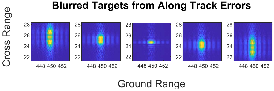 Figure 1: Comparison of Shift (top) and Blur (bottom) distortions caused by Position and Velocity errors.
Experiments & Results
The study evaluated three datasets: simulated data and two real-world datasets with different aperture lengths (2s and 10s).
Key Breakthroughs:
- Resolving Ambiguity: In Scenario 4 (CT and Down position errors), the network effectively separated the sources of error, even though both lead to similar shifts.
- The Aperture Effect: As the synthetic aperture length increased from 2s to 10s, the network’s ability to characterize "blurs" improved dramatically. Velocity error estimation accuracy jumped by 25-50%.
- Real-World Generalization: The model was tested on targets it had never seen before, proving it learns the dynamics of distortion rather than just memorizing specific landmarks.
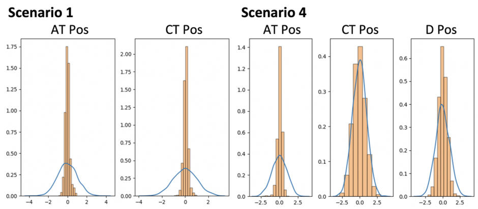 Figure 2: Error distributions before (blue line) and after (histogram) CNN estimation. The narrowing toward zero indicates successful error correction.
Performance Summary (MSE):
| Scenario | Error Source | Sim-5s MSE | Real-2s MSE |
|---|---|---|---|
| 1 (Simple) | AT / CT Pos | ~0.04 | ~0.05 |
| 6 (Complex) | Full 6-DOF | ~0.70 | ~0.80 |
Critical Insight & Conclusion
The true value of this work lies in the Transferability of Image Features. It is remarkable that a network trained on the ImageNet dataset can be fine-tuned to understand the physics-based distortions of radar imagery.
Limitations: Performance still degrades as more error variables are added (Scenario 6), suggesting that while the CNN is powerful, it cannot yet fully overcome the fundamental mathematical "ill-posedness" of 9-state estimation from a single image.
Future Work: The authors suggest incorporating viewing geometry (the angle between the aircraft and the target) as metadata to the network. This "context-aware" training could be the final step toward a fully autonomous, SAR-based replacement for GPS.
Takeaway: If your GPS fails, the artifacts in your radar images are no longer "noise"—they are the signals you need to find your way home.