
GSFord: Bridging the "Dead Zone" in Disaster Notifications via Geo-Social Diffusion
GSFord: Towards a Reliable Geo-social Notification System
GSFord is a geo-social event notification system designed for disaster scenarios, combining a robust P2P architecture (RRTree) with a social diffusion mechanism. It achieves nearly 100% message coverage even during massive, geographically correlated infrastructure failures by leveraging out-of-band communication triggered via stored social relationships.
TL;DR
When disasters strike, the very networks meant to carry warnings are often the first to fail. GSFord is a dual-layered notification system that overcomes infrastructure blackouts by combining a resilient P2P overlay (RRTree) with a human-centric "social diffusion" process. By identifying friends and family of those in danger, GSFord triggers targeted out-of-band alerts (calls/texts), achieving a staggering 99.9% reachability even under massive regional failures.
Problem: The Fragility of Digital Geography
Most disaster alerting systems—whether cell broadcasts or satellite relays—share a common "Achilles' heel": Geographically Correlated Failures. If an earthquake destroys the cell towers in a specific "Possibly Damaged Region" (PDR), those inside are effectively invisible to the network.
Current academic solutions like Application Layer Multicasting (ALM) or Geo-aware P2P systems solve for scalability but ignore two crucial factors:
- Social Significance: People outside the disaster zone are desperate to reach those inside.
- Physical Isolation: Total loss of digital connectivity requires "out-of-band" intervention (e.g., a phone call from a relative in another state).
Methodology: RRTree and Geo-Social Awareness
The core of GSFord lies in its two logical overlays built upon a Responsible Region Tree (RRTree).
1. The Delivery Overlay (DOv)
The DOv handles the "What" and "Where." Using a hierarchical structure that adapts to population density (RRTree growth/shrinkage), it ensures that if you are in a healthy network zone, you get the message instantly.
2. The Information Overlay (IOv)
This is the "Who." Managed only by Trusted PNodes (T-PNodes) for privacy, it stores the mapping of Social IDs (SIDs) to geographical locations.
- Conjugate Replication: To ensure this data isn't lost when the disaster hits, GSFord replicates "Region A's" data to a "Conjugate Region A’" (a geographically distant quadrant), inspired by the "out-of-state emergency contact" concept.
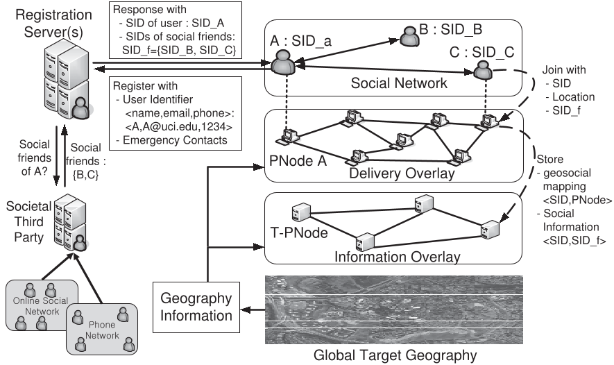 Figure 1: High-level GSFord architecture showing the interaction between Geo-Social data and regional notification.
3. Targeted Social Diffusion
The breakthrough is how GSFord handles the unreachable. Once the system identifies a target region, it identifies "Socially Correlated" users—friends/family living outside the danger zone. GSFord sends these users customized messages:
- PDR-Targeted: "Your friend [Name] is in a high-danger blackout zone. Please call or reach them immediately."
Experiments & Results: Resilience in Crisis
The authors simulated GSFord using social network data (50k nodes) mapped onto Southern California demographics.
- Near-Total Coverage: While standard Geo-overlays plateau at 20-30% reachability when a region is 80% destroyed, GSFord continues to climb, hitting nearly 100% as social diffusion takes over.
- Latency Advantage: 90% of recipients receive notifications significantly faster due to the precision of the RHT (Region Hopping Table) routing, which allows messages to bypass tree hierarchies.
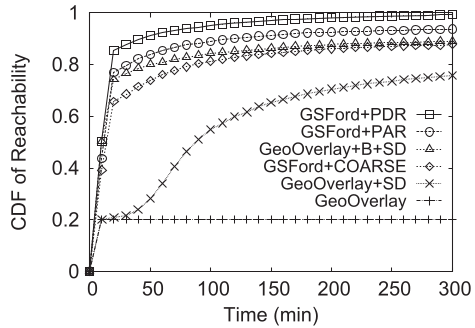 Figure 2: Reachability Comparison. Notice how GSFord (top lines) maintains high coverage compared to GeoOverlay alone (bottom line) as time progresses.
Critical Insight: Why GSFord Matters
The genius of GSFord isn't just in the P2P math; it's in the Incentive Alignment. Most "gossip" protocols rely on random node-to-node sharing. GSFord recognizes that in a crisis, social bonds provide a much stronger "signal" than random routing. By turning "social acquaintances" into "emergency relays," the system bridges the "last mile" that digital signals cannot cross.
Limitations & Future Work
While robust, GSFord's reliance on "Trusted PNodes" for social data storage raises significant privacy concerns. Future iterations will need to explore Zero-Knowledge Proofs or decentralized encryption to ensure social maps aren't exploited. Additionally, moving the system to purely mobile/wireless environments (where nodes move during the disaster) remains an open challenge.
Summary Takeaway
GSFord proves that Geo-Social redundancy is the key to disaster resilience. By using the world's most stable network—our social connections—we can ensure that even when the towers fall, the message still gets through.