
Hadath: Redefining Digital Maps through Multi-Resolution Event Extraction
Hadath: From Social Media Mapping to Multi-Resolution Event-Enriched Maps
Hadath is a multi-resolution mapping system that extracts and visualizes "Events of Interest" (EoI) from heterogeneous social media streams like Twitter and Flickr. It employs a hierarchical spatio-temporal indexing and clustering framework to adaptively display events based on map zoom levels, achieving real-time processing of millions of geotagged microblogs.
TL;DR
Hadath is a sophisticated framework designed to transform static digital maps into "live" event-enriched environments. By harvesting unstructured data from social media and utilizing a hierarchical clustering mechanism, the system identifies the spatio-temporal scope of events. This ensures that a city-wide marathon is visible at a high zoom level, while a local cafe opening only appears when the user dives into the neighborhood view, effectively solving the "clutter" problem in real-time mapping.
The "Static Map" Problem and the Motivation for Vitality
Despite the ubiquity of Google Maps and Waze, our digital maps remain largely "blind" to the social context of our surroundings. We see restaurants and traffic jams, but we miss the ephemeral gatherings, local protests, or festive celebrations that define a city's current state.
The researchers identified a critical gap: when previous systems tried to display social media "blips" on a map, they often resulted in an unreadable mess of icons. The core intuition behind Hadath is that every event has a natural resolution. To build a truly smart map, the system must understand not just what is happening, but how far its influence reaches.
Methodology: The Core Engine of Hadath
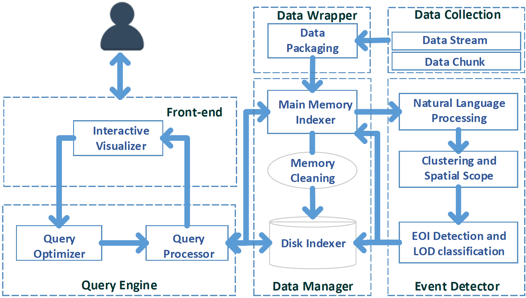
The architecture of Hadath is a pipeline designed for massive throughput and semantic clarity.
1. Generic Data Packetization
To handle the "Wild West" of social media formats (Twitter, Instagram, Yelp), Hadath wraps all incoming data into a standardized structure consisting of a Header (Metadata like source, GPS, timestamp) and a Payload (Text content/User profiles).
2. Hierarchical Spatio-Temporal Indexing
The system uses an in-memory indexing scheme similar to a partial quad-tree. This allows the system to partition the world into manageable "cells." As data density increases in a specific area, the cell "splits" into deeper, more granular levels.
3. Louvain Clustering at Scale
Within each leaf cell, the system treats data packets as nodes in a graph. By calculating TF-IDF (Term Frequency-Inverse Document Frequency) similarity between posts, it uses the Louvain algorithm to group similar activities into "Events of Interest" (EoI) without needing to be told how many clusters to find beforehand.
Multi-Scale Visualization: Eliminating Clutter
The "magic" of Hadath lies in its bottom-up spatial aggregation. If multiple smaller events in neighboring cells are semantically similar, the system merges them into a higher-level "super-event" with a wider spatial scope.
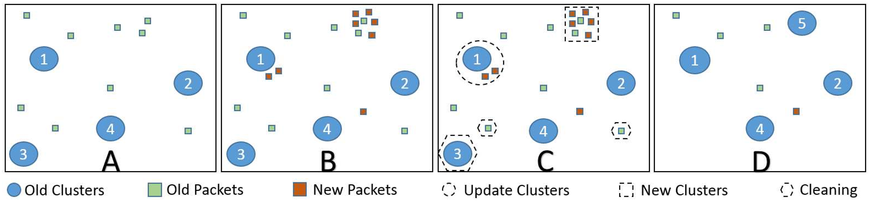
This results in a clean UI:
- City Scale: Only "Global" events (e.g., massive concerts) are visible.
- Neighborhood Scale: Micro-events (e.g., a local bakery promotion) appear.
Experimental Results & Performance
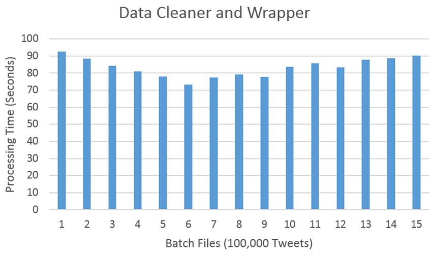
The system was stress-tested against 30 million geotagged tweets. Performance metrics showed that even under heavy load, the system maintains a low query latency (e.g., retrieving ~135k events in just 179ms).
| Scale | Precision | Recall | F1-Score |
|---|---|---|---|
| Local | 0.82 | 0.80 | 0.81 |
| Neighborhood | 0.93 | 0.92 | 0.92 |
| City | 1.00 | 0.99 | 0.99 |
The table shows that as we move up to the "City" scale, the system's ability to filter out noise and identify major events becomes nearly perfect.
Critical Insight & Future Outlook
Takeaway: Hadath proves that digital maps can be more than navigation tools; they can be real-time urban sensors. By automating the extraction of significance and scope, the system moves the burden of information filtering from the user to the algorithm.
Limitations: Currently, the system relies heavily on text-based similarity. Future iterations could benefit from incorporating image analysis (Computer Vision) to verify events via Flickr/Instagram photos, further reducing the impact of "noise" or fake microblogging. Hadath lays the groundwork for the next generation of "Living Maps" that adapt to the heartbeat of the modern city.