
HandYwiN: Bridging the "Last Meter" Gap in Smart City Mobility
HandYwiN: a crowdsourcing-mapping solution towards accessible cities
This paper introduces HandYwiN, a crowdsourcing-based mobile mapping platform designed to improve urban mobility for people in wheelchairs. By leveraging community participation, the system identifies and marks the accessibility levels of public and private spaces on a digital map, facilitating the creation of truly inclusive Smart Cities.
TL;DR
The HandYwiN initiative addresses a critical blind spot in Smart City planning: the physical accessibility of destinations for wheelchair users. By using a crowdsourced mapping mobile application, it transforms ordinary citizens into "accessibility sensors," providing a real-time, color-coded map of urban inclusivity based on expert-validated architectural criteria.
The "Invisibility" of Disability in Smart Cities
Modern Smart City discourse is often dominated by high-level metrics like traffic throughput, IoT infrastructure, and energy efficiency. However, for a person in a wheelchair, a city is only as "smart" as its lowest curb or its narrowest door.
The author points out a sobering reality: 60% of global smart city experts admit that current models are failing vulnerable populations. The core issue is that existing mobility metrics (like the Giffinger model) equate "accessibility" with "proximity to public transport," ignoring the physical barriers at the destination that prevent a person from actually using the service.
Methodology: The APCU Accessibility Chain
To solve this, HandYwiN moves away from simple GPS tracking and adopts a human-centered "crowdsourcing-mapping" solution. The methodology is rooted in the APCU Chain, which views accessibility not as a single point, but as a continuous sequence of actions:
- Achieve: Reaching the building.
- Penetrate (Enter): Crossing the threshold.
- Circulate: Moving within the space.
- Use: Interacting with services (e.g., counters, toilets).
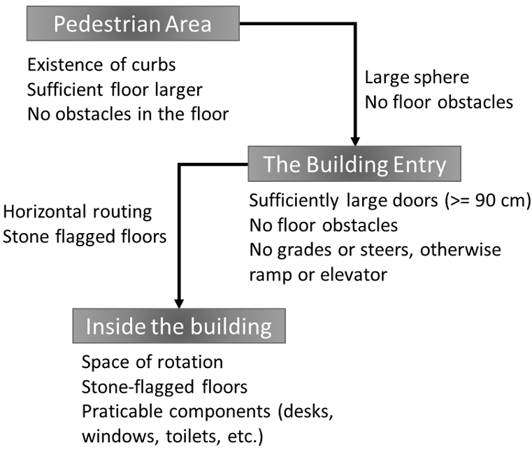 Figure 1: The APCU chain ensures that every stage of a visit is evaluated.
Converting Expert Knowledge into Citizen Action
The genius of HandYwiN lies in its translation of complex architectural standards into simple, binary (Yes/No) questions. Instead of asking for a ramp's slope percentage, the app asks: "Is the walkway large enough for two people to walk together?" or "Can the door be opened from a sitting position?"
Experimental Results & Real-World Impact
The application was developed for Android and deployed in Tunisia. A preliminary survey of 35 wheelchair users established a priority list of services that need mapping most urgently:
| Category | Key Services Identified |
|---|---|
| Commerce | Shops, Markets, Grocery Stores |
| Restaurant | Coffee shops, Pizzerias |
| Administration | Post offices, Municipalities, Banks |
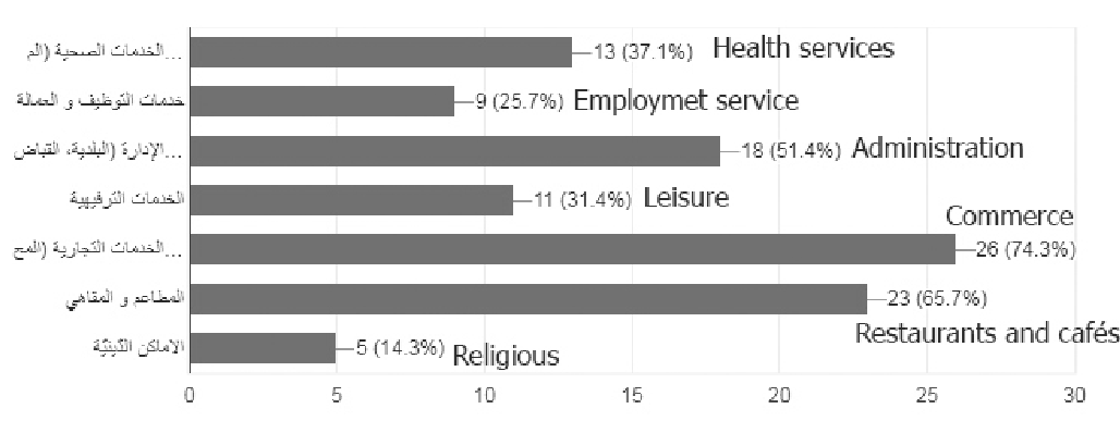 Figure 2: Survey ranking of the most vital services for wheelchair accessibility.
The app uses a strict scoring system:
- Green (100%): Fully accessible.
- Orange (60-99%): Modularly accessible.
- Red (0-59%): Not accessible.
Critical Insight: Updating the Smart City Model
The paper’s most significant academic contribution is the proposed update to the Smart Mobility factors. The author argues that "Local Accessibility" (availability of information for persons with reduced mobility) should be an independent factor alongside "Local Transportation."
| Proposed Factor | New Indicators |
|---|---|
| Local Accessibility | Availability of accommodations; Accessibility Information; Communication standards |
Conclusion & Future Outlook
HandYwiN demonstrates that technology acts as a bridge between urban planning and social inclusion. While currently focused on physical mobility, the future of the project looks toward:
- Visual Disability Support: Incorporating auditory and tactile data.
- Dynamic Route Planning: Developing specialized algorithms to find the most "accessible path," not just the shortest one.
The Takeaway: A city isn't "smart" unless it is accessible to everyone. Crowdsourcing provides a scalable, cost-effective way to audit the physical world and hold governments accountable for universal design.