
Heterogeneous Cooperative Localization: Turning Social Networks into Navigation Infrastructure
Heterogeneous Cooperative Localization for Social Networks
This paper introduces a heterogeneous cooperative localization framework for indoor social networks, utilizing ranging-free probabilistic algorithms (Centroid, Nearest Neighbor, Kernel, and AP Density). By leveraging outdoor mobile nodes as GPS-calibrated anchors and sharing RSSI data from indoor Access Points (APs), the system achieves robust indoor positioning without specialized ranging hardware or extensive fingerprinting databases.
TL;DR
Indoor localization has long been a "holy grail" of mobile computing. While GPS fails behind thick walls, this paper proposes a cooperative localization framework that uses smart-phones in social networks as mobile anchors. By using four ranging-free probabilistic algorithms—Centroid, Nearest Neighbor, Kernel, and the novel AP Density scheme—it achieves higher accuracy than traditional WiFi Positioning Systems (WPS) without needing expensive specialized hardware.
The Motivation: Why Ranging and Fingerprinting Fail
Most indoor positioning systems rely on two flawed pillars:
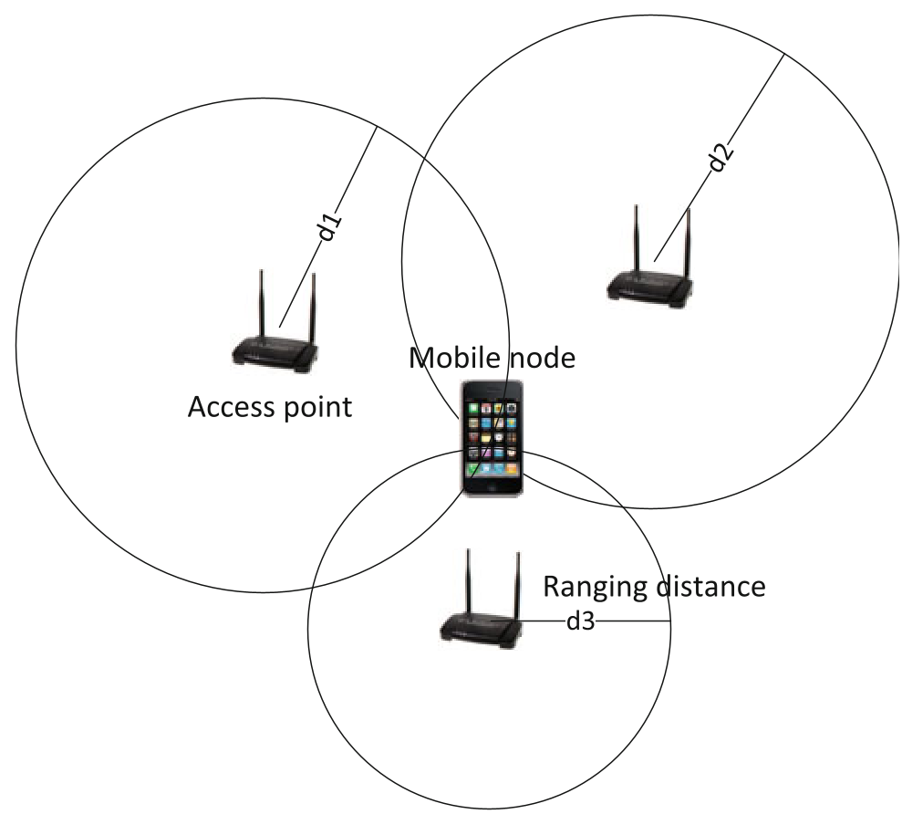
- Ranging-Based (TOA/RSS): These measure the time of arrival or signal strength to calculate distance. In the "urban canyon" or indoor office, multipath fading and signal blockage (NLOS) make these readings wildly inaccurate.
- Fingerprinting: This requires mapping every square meter of a building beforehand. It’s a maintenance nightmare—move one sofa or change one router, and the map is broken.
The authors ask a brilliant question: What if the people standing just outside the building (with good GPS) or nearby (with known RSS signatures) could help locate those inside?
Methodology: The Power of Cooperation
The system uses a two-stage process. First, it identifies outdoor "anchors" with valid GPS locks. Second, it uses the shared "view" of wireless Access Points (APs) to estimate the positions of indoor users.
The Four Competitors
The paper evaluates four Bayesian-oriented algorithms to process this shared data:
- Centroid Method: The simplest—it just averages the coordinates of all detected anchors.
- Nearest Neighbor: Picks the location of the anchor with the closest RSS signature.
- Kernel Method: Uses a Gaussian Kernel to assign probabilities to various locations based on RSS distributions.
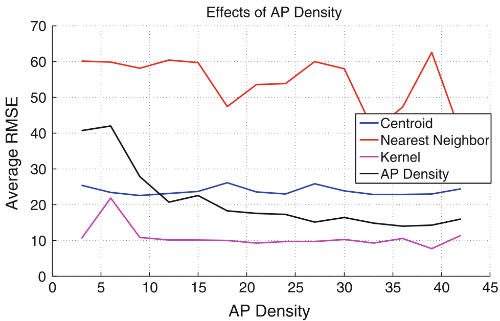
- AP Density Scheme (The Gold Standard): This method leverages the degree of overlap. If your phone and an anchor see 10 of the same APs, you are likely much closer to that anchor than if you only shared 2 APs.
Experiments: Real-World Testing
The researchers didn't just stay in the lab. They tested the algorithms in two distinct environments:
- Suburban (AKL Lab): Sparse buildings, relatively clear signals.
- Dense Urban (Boston Downtown): Tall buildings, high shadow fading.
Key Insights from Results
A critical finding was the Node Topology effect. If your anchors are all on one side of you (a linear topology), error rates spike. However, when anchors "triangulate" the user, the AP Density method provides significantly better accuracy than the commercial Skyhook WPS.
Critical Analysis & Future Outlook
The paper is a landmark in showing that ranging-free methods can compete with ranging-based ones if you have enough "cooperative" data.
Strengths:
- Zero Hardware Cost: Works on any standard Android device (as demonstrated with the Galaxy S).
- Scalability: Performance actually improves as the social network becomes denser.
Limitations:
- GPS Dependency: The system is only as good as the GPS accuracy of the outdoor anchors. If the "anchors" have poor fixes, the error propagates.
- Static vs. Dynamic: The paper focuses on snapshot localization; future work needs to integrate Inertial Measurement Units (IMUs) to track movement in real-time.
Conclusion
Heterogeneous Cooperative Localization shifts the paradigm from "infrastructure-heavy" to "collaboration-heavy." By treating every smartphone in a social network as a possible reference point, we can turn the chaos of indoor signal interference into a structured, navigable map.
Senior Editor's Note: This research highlights a pivotal shift toward "crowdsourced" infrastructure, a trend that has since influenced modern indoor positioning standards in 5G and beyond.