
How Well Did You Locate Me? Unmasking the Bias in Social Media Geolocation Evaluation
How Well Did You Locate Me? Effective Evaluation of Twitter User Geolocation
This paper presents a comprehensive meta-evaluation of fifteen Twitter user geolocation models and two baselines, standardizing the evaluation process using a unified output format (GPS coordinates resolved via Google Geocoding API). The study reveals that the choice of metrics—such as Accuracy, Precision/Recall, and error distance—significantly impacts model rankings and conclusions.
TL;DR
Precision in geolocating social media users is vital for disaster management and epidemic tracking. However, this paper reveals a startling truth: we might be judging our models all wrong. By standardizing the evaluation of 15 models, the authors prove that "State-of-the-Art" status is often a byproduct of metric choice rather than actual superiority, especially when population bias remains unchecked.
The Blind Spots of Geography
Geolocating Twitter users is a high-stakes task. Whether it's a journalist looking for a local eyewitness or health officials tracking a rural virus outbreak, knowing where a tweet comes from is essential. Yet, despite years of research, the community has lacked a consistent yardstick.
The problem is twofold:
- Representation Mismatch: One model predicts using a grid, while another predicts at the city level. Comparing them is like comparing apples to oranges.
- Urban Bias: Most tweets come from big cities. If a model simply guesses "New York" every time, its Accuracy might look great, but it is useless for monitoring a wildfire in a remote forest.
Methodology: Levelling the Playing Field
To solve this, the authors introduced a Standardized Evaluation Process.
1. Unified Output
Instead of letting models stay in their proprietary formats (grids, clusters, or city names), all outputs were converted to GPS coordinates. By using the Google Geocoding API as a single source of truth, they could evaluate every model at four granularities: City, County, State, and Country.
2. Micro vs. Macro Averaging
This is the paper’s "Secret Sauce."
- Micro (): Treats every user equally. If most users are in London, London dominates the score.
- Macro (): Treats every location equally. This forces the model to prove it can identify a user in a tiny village just as well as one in a metropolis.
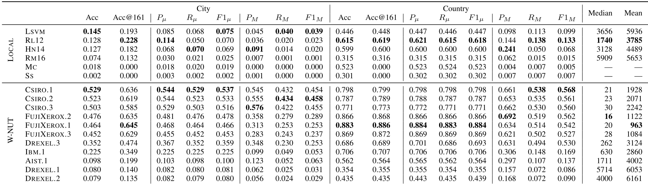 Table 1: The performance volatility across different metrics and granularities.
Key Insights from the Lab
The results from the LOCAL and W-NUT datasets provided some sobering realizations:
- The Ranking Paradox: A model like
LSVMachieved the best Accuracy at the city level, but its Precision plummeted when switched to Macro-averaging. This impliesLSVMis an "urban specialist" that fails the moment it leaves the city limits. - The Power of Simplicity: At the country level, a dummy baseline that always guessed the most frequent country (Majority Class) outperformed several complex machine learning models. If your expensive Neural Network can't beat a fixed guess, is it really learning geography?
- Grid vs. City: Grid-based models (like
RL12) naturally show lower error distances because their "center point" is mathematically optimized, whereas city-based models are penalized by the arbitrary centers of large metropolitan areas.
Critical Analysis & Future Outlook
The paper successfully dismantles the myth of a single "Best Model." It highlights that CSIRO and FUJIXEROX models—the titans of the W-NUT task—trade blows depending on whether you value Accuracy at or Macro-F1 scores.
Limitations: While the standardization is robust, the study relies on the Google Geocoding API, which introduces its own proprietary bias. Furthermore, the focus on English-only tweets ignores the linguistic nuances of geolocation in multilingual regions.
The Takeaway for Developers: If you are building a geolocation tool, stop reporting just Accuracy. You must show Macro-F1 to prove you aren't just memorizing population maps, and you must compare against a Majority Class baseline to prove your model's worth.