
Hybrid Path Planner: Bridging Network Routing and Spatial AI for Smart Cities
Hybrid Path Planner for Efficient Navigation in Urban Road Networks through Analysis of Trajectory Traces
The paper introduces a "Hybrid Path Planner" that combines computer networking routing table concepts with AI pathfinding to optimize urban navigation. By partitioning road networks into hexagonal grids and identifying hot-spots via Deep Embedded Clustering, the system achieves real-time, adaptive routing with linear space complexity.
TL;DR
Researchers from IIT Kharagpur have unveiled a Hybrid Path Planner that re-imagines city traffic as a data network. By adapting the concept of routing tables from computer networking and combining them with Deep Embedded Clustering, they've created a system that computes optimal routes faster than A* while maintaining a linear memory footprint (), making it ideal for mobile integration.
Background Positioning
In the landscape of path planning, we often choose between the "calculate everything" approach (Floyd-Warshall) which consumes massive memory, or the "calculate on-the-fly" approach (A*, Dijkstra) which can be slow under dynamic conditions. This work sits precisely in the middle: it is an adaptive SOTA bridge that uses historical trajectory data to pre-calculate the most likely high-traffic routes (Hot-spots) while leaving the edge cases to lightweight local search.
Problem & Motivation: The Resource Bottleneck
Modern navigation faces a paradox: as data grows (GPS traces, bike-trip data, CDRs), the ability of low-resource end-devices like smartphones to process this "Big Data" in real-time diminishes.
- Space Complexity: Storing all-pairs shortest paths for a city requires space—mathematically impossible for a mobile app.
- Temporal Dynamism: Traffic is not a static weight; it is a "weighted average density" that changes by the hour. A path that is optimal at 3 AM is a bottleneck at 9 AM.
Methodology: The Core Mechanism
The authors' "Hybrid" approach relies on three sophisticated technical pillars:
1. Hexagonal Grid Partitioning
Unlike square grids, hexagonal grids simplify distance calculations and diagonal movement. The system assigns every node a GridID, segmenting the urban sprawl into manageable cells.
2. Deep Hot-Spot Discovery
The system doesn't just guess where people go; it uses Deep Embedded Clustering to identify high-importance nodes (Hot-spots) based on net traffic flux (influx vs. outflux). They use a Gaussian kernel trick, similar to SVMs, to determine the optimal number and radius of these hot-spots.
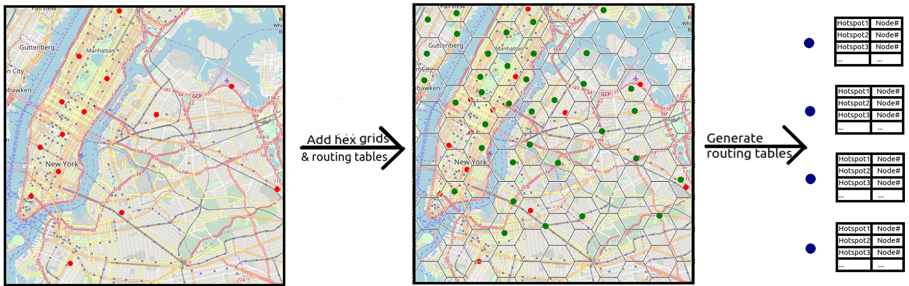 Fig 1: Simplified visualisation for the generation of routing tables and grid-based partitioning.
3. The "Memoryless" Routing Table
Each node stores a hash table of nearby hot-spots and the "next best edge" to reach them. When a user requests a path:
- If the destination is a hot-spot: The node "blindly" follows the routing table (extremely fast).
- If it's a new location: The system uses an A* planner locally until it hits a known hot-spot route.
Experiments & Results
The framework was tested using the NYC Taxi and Limousine Commission dataset, comparing its performance against a standard A* implementation.
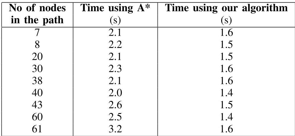 Table 1: Time efficiency comparison. The Hybrid algorithm remains consistently fast (approx. 1.5s) even as the path length increases, whereas A shows higher latency.*
Key Takeaways from Experiments:
- Efficiency: The hybrid approach reduced computation time by nearly 50% for longer paths (61 nodes).
- Adaptability: By using a "hierarchical update," when one road’s weight changes, only the nearest neighbors' routing tables are updated first, preventing a system-wide computational spike.
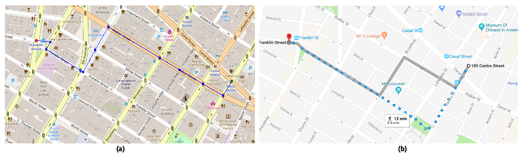 Fig 2: Simulated comparison showing the algorithm's output vs. Google Maps, proving its accuracy in real-world scenarios.
Critical Analysis & Conclusion
Takeaway
The genius of this work lies in its Inductive Bias: it assumes that human movement isn't random but gravitates towards specific sinks (hot-spots). By caching these high-probability routes in local routing tables, it solves the "memory vs. speed" trade-off.
Limitations
Currently, the system relies on the historical precision of the NYC taxi data. In cities with less structured transit data or rapidly changing infrastructure, the "dynamic hot-spot" frequency might lead to a high rate of routine table misses, forcing the system back into a standard A* search.
Future Work
The next frontier is predictive navigation—forecasting traffic behavior in one sector based on patterns in another. By filtering and "cleaning" the noisy GPS data, the authors aim to make the system resilient even to partial data availability.