
Hybrid Intelligence in the City: Redefining Ridesharing via Geosocial Networks and ACO
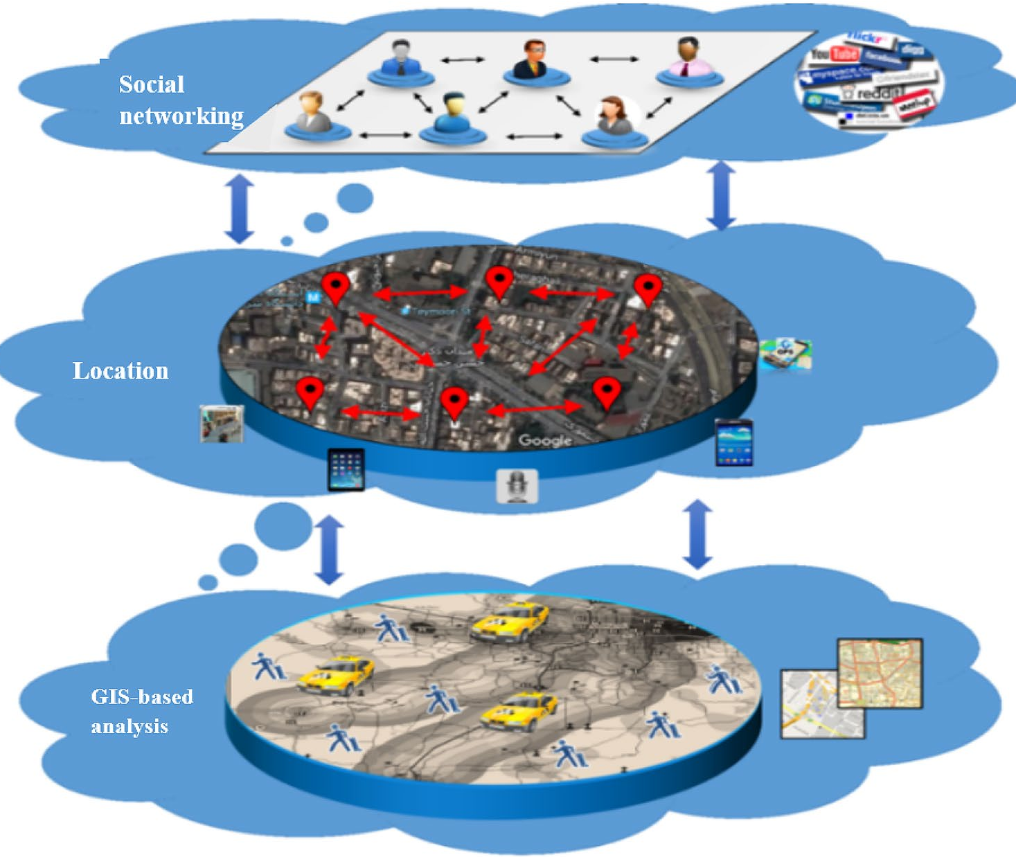
A hybrid ridesharing algorithm based on GIS and ant colony optimization through geosocial networks
This paper presents a hybrid ridesharing algorithm that integrates GIS-based spatial analysis with Ant Colony Optimization (ACO) within a geosocial network (Telegram). The method sequentially applies K-means clustering, topological matching (VCRQ, RCC5, Allen’s Algebra), and ACO to achieve optimal matching and routing for dynamic carpooling in Tehran.
TL;DR
To combat urban congestion and the inefficiency of private car usage, researchers have developed a hybrid algorithm that bridges the gap between GIS (Geographic Information Systems) and social media. By deploying a Telegram-based bot, the system uses a sophisticated pipeline of K-means clustering, Topological Matching (RCC5 + Allen’s Algebra), and Ant Colony Optimization (ACO) to create a dynamic, road-network-aware ridesharing service that outperforms traditional metaheuristic baselines.
The "Shortest Path" Isn't Enough: The Motivation
Most current ridesharing apps suffer from "Euclidean Blindness"—they calculate matches based on bird-fly distances rather than actual road constraints. Furthermore, matching individual passengers one-by-one is computationally expensive and often misses the benefits of group clustering.
The authors identified that an optimal system must solve three things simultaneously:
- Where are the people? (Spatio-temporal clustering)
- Can the driver actually reach them? (Road-network matching)
- What is the best sequence? (Multi-objective routing)
Methodology: The Three-Stage Engine
The paper’s core contribution is its structured hybrid approach, moving from coarse-grained clustering to fine-grained route optimization.
1. Spatio-temporal Clustering (K-means)
The system doesn't just look for passengers; it looks for communities of movement. Using K-means, it clusters passengers by origin/time and then verifies if their destinations are reachable within their maximum waiting time ().
2. The GIS Matching Layer (VCRQ + RCC5 + Allen)
This is where the "Academic Heavy Lifting" happens. Instead of a simple radius search, the system uses:
- VCRQ: Defines a driver's "influence zone" based on velocity and the urban road network.
- RCC5: A topological logic that determines spatial overlaps between the driver's zone and passenger clusters.
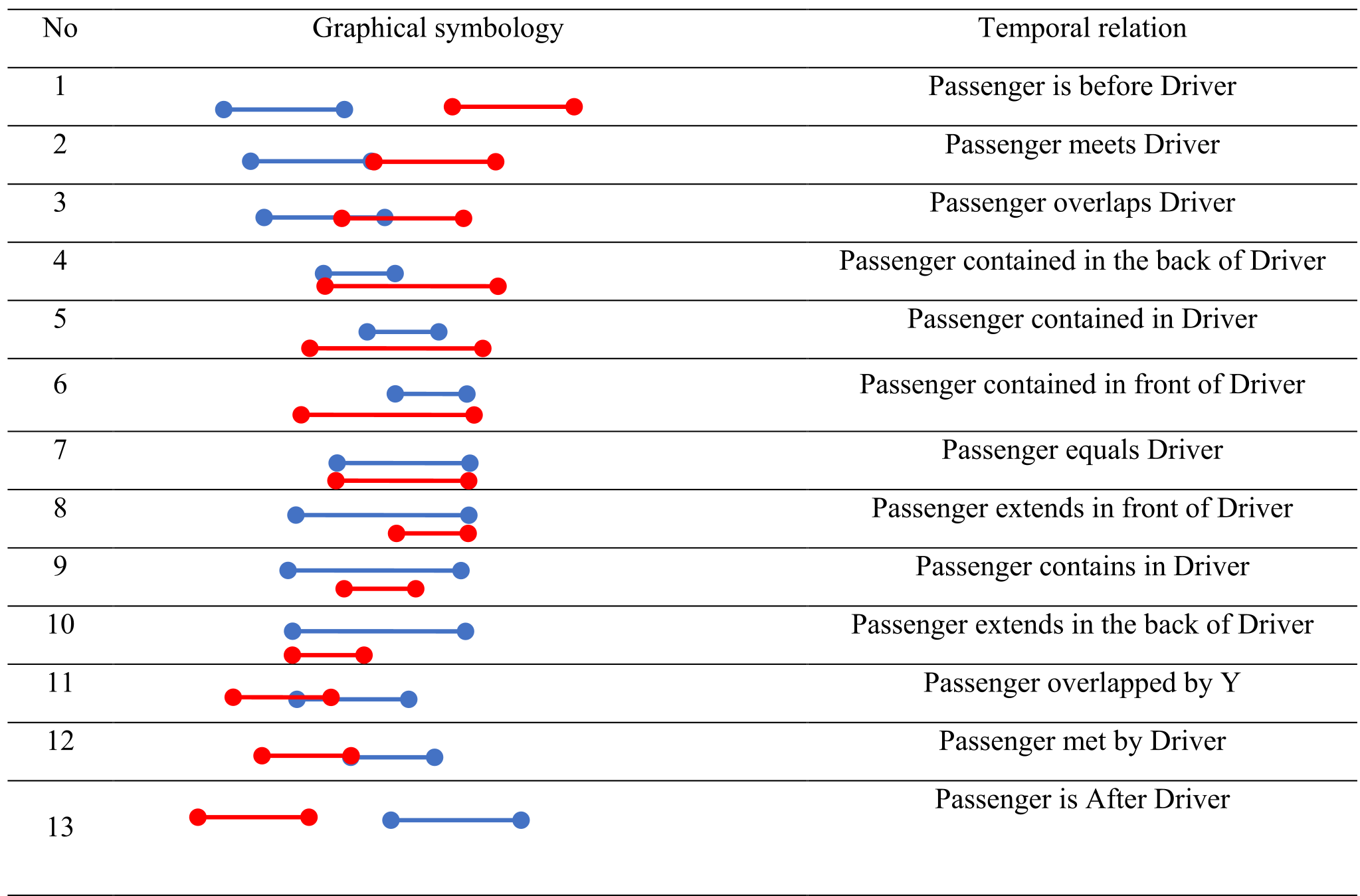
- Allen’s Interval Algebra: Synchronizes 13 possible temporal relations (e.g., meets, overlaps, during) to ensure the driver and passenger are at the same place at the same time.
3. Route Optimization (ACO)
Once candidates are matched, the Ant Colony Optimization algorithm takes over. ACO is chosen for its superior performance in dynamic graphs. The cost function is a weighted sum of: Where is travel time, is waiting time, and is delay time.
Experiments & Real-World Impact
The system was tested in District 6 of Tehran, a high-traffic urban center.
- Execution Time: The algorithm is highly efficient. For a typical urban graph (30-100 nodes), it finds the optimal route in 2 to 6 seconds, reaching a maximum of 195 seconds for extremely complex routes.
- Economic Benefit: Passengers saw a 43% reduction in fares compared to private taxis, while drivers increased their earnings via a 36% surcharge/bonus for multi-passenger trips.
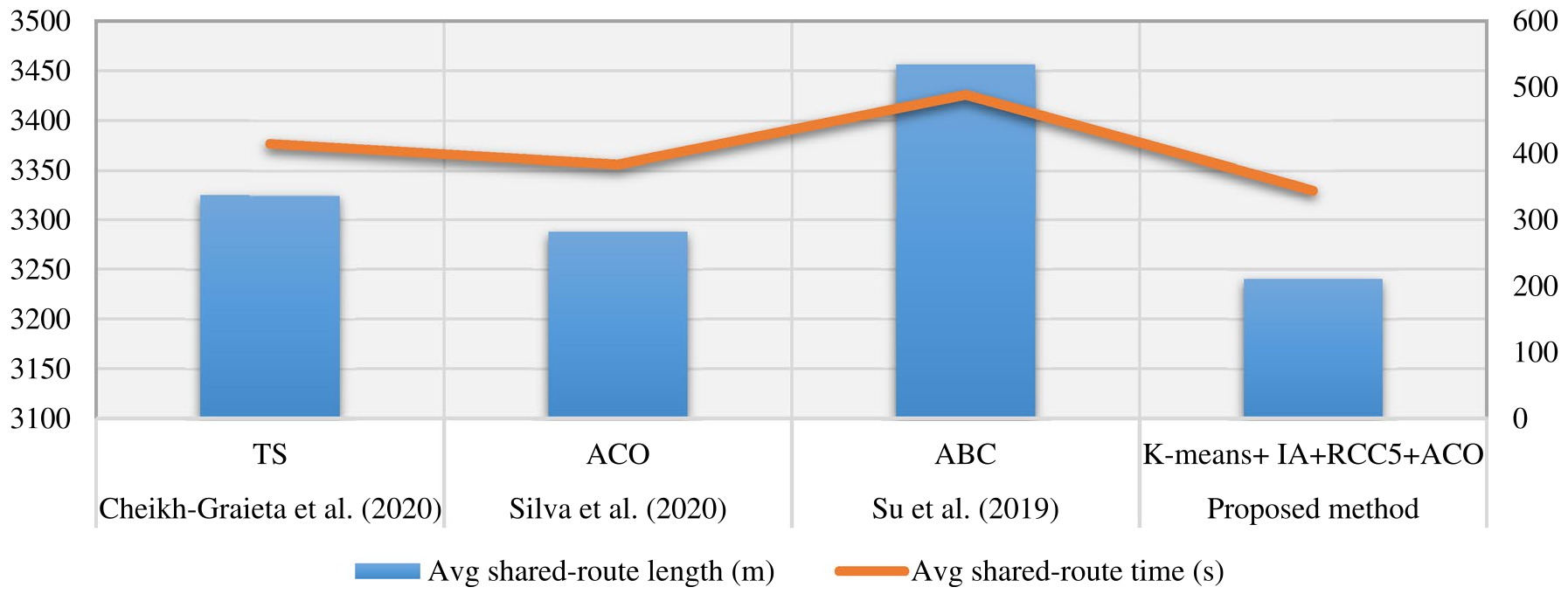
- Comparative Performance: When pitted against Tabu Search (TS) and Artificial Bee Colony (ABC) algorithms, this hybrid approach consistently yielded shorter route lengths and higher occupancy rates (more trips with 4 passengers).
Critical Insight & Conclusion
The true power of this research lies in its context-awareness. By utilizing the Telegram API, the authors bypassed the "app fatigue" barrier, placing a complex GIS tool directly into a platform users already trust.
Takeaway: Future urban mobility solutions must stop treating "location" as a single coordinate and start treating it as a dynamic "influence zone" shaped by traffic, velocity, and social connectivity. While the current model lacks real-time speed data integration, its logical framework provides a robust blueprint for the next generation of Geosocial Network (LBSN) services.