
Tracking Productivity from Space: Why Hyperspectral Imaging is the Future of Desert Agriculture
Time series from hyperion to track productivity in pivot agriculture in saudi arabia
This study utilizes hyperspectral time series from the Hyperion sensor to estimate canopy chlorophyll (Chlc), Gross Primary Productivity (GPP), and agricultural yield in Saudi Arabian pivot farms. Using a machine learning approach (Cubist), researchers demonstrated that hyperspectral data significantly outperforms multi-spectral alternatives like Landsat-8 and Sentinel-2 in predicting crop traits.
TL;DR
Researchers from KAUST and NASA have demonstrated that hyperspectral satellite data from the Hyperion sensor can track crop health and predict yields in Saudi Arabian desert farms with far greater precision than standard satellites like Landsat-8. By leveraging machine learning and narrow-band spectral signatures, they achieved a significant reduction in error (MAD ~26%) when estimating canopy chlorophyll and productivity.
Background: The Limits of "Standard" Vision
In the harsh, high-contrast environment of Saudi Arabian pivot agriculture—where lush green circles sit amidst bright, reflective sands—standard multi-spectral satellites often hit a "glass ceiling." Sensors like Landsat-8 see the world in broad color chunks. While useful, they struggle to distinguish the subtle "red-edge" shifts and biochemical nuances that signal plant stress or peak productivity.
The motivation for this study is the upcoming "Hyperspectral Era." With missions like ENMAP and HyspIRI on the horizon, we need to know: can these narrow spectral bands (10 nm or less) actually solve the accuracy issues of the past?
Methodology: From Photons to Harvest Totals
The researchers combined high-frequency Hyperion acquisitions (utilizing off-nadir viewing to get up to 5 images every 16 days) with ground truth data from five field campaigns.
The Machine Learning Core: Cubist
Instead of relying on a single Vegetation Index (like NDVI), the team used Cubist, a rule-based model-tree approach. They fed it a massive suite of:
- Narrow-band Indices: Targeting specific chlorophyll absorption features.
- First Derivative Indices: Capturing the slope of the reflectance curve.
- Continuum Removal: Normalizing the spectra to isolate biochemical signals from soil background.
From Chlorophyll to Yield
The workflow followed a logical physical chain:
- Retrieve Chlc: Using the Cubist model.
- Calculate GPP: Using the relationship , a proxy for the plant's "engine" capacity.
- Predict Yield: Integrating GPP over the season and applying conversion factors for Carbon Use Efficiency (CUE) and Harvest Index (HI).
Results: The Hyperspectral Advantage
The study’s most striking finding is the robustness of hyperspectral data.
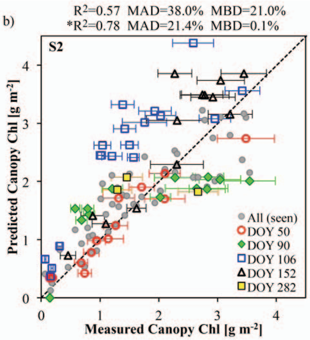
When tested on "unseen" data (data the model wasn't trained on), the performance of multi-spectral models (Landsat/Sentinel) crashed, with errors jumping to nearly 50%. In contrast, the hyperspectral model remained stable.
- Hyperspectral: R² = 0.72 | MAD = 26.5%
- Sentinel-2 (Simulated): MAD = 38.0%
- Landsat-8 (Simulated): MAD = 48.9%
The inclusion of Red-Edge bands (available in Sentinel-2 but absent in Landsat-8) helped, but the full hyperspectral suite provided the ultimate "resistance" to obfuscating factors like dust aerosols and soil brightness.
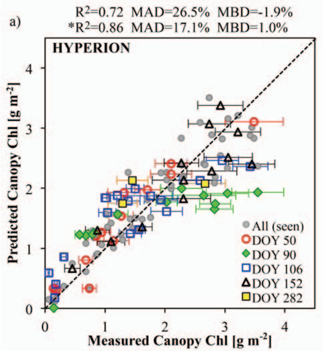 Figure: The clear superiority of Hyperion (a) over Sentinel-2 (b) and Landsat-8 (c) configuration in predicting Canopy Chlorophyll.
Critical Insight & Future Outlook
This work highlights that for Precision Agriculture, "more bands are better than wider bands." The ability to track the dynamics of various crops (Alfalfa, Rhodes grass, Maize) using a single cross-validated model suggests that hyperspectral sensors capture the actual physiology of the plants rather than just "greenness."
Limitations: The study notes that atmospheric correction remains a major hurdle. Desert dust and "adjacency effects" (where light reflects off the bright sand into the green pixel) still introduce noise that machine learning cannot entirely ignore.
Future Work: As commercial hyperspectral CubeSat constellations launch, this methodology allows for daily, high-resolution monitoring of every farm on Earth, potentially revolutionizing how we handle global food logistics and carbon accounting.
Takeaway
If we want to feed a growing planet using desert agriculture, we must move beyond the "broadband" era of the 1970s and embrace the "biological fingerprinting" offered by hyperspectral time series.