
Wi-City-Plus: Bridging the Gap between Sensors and Society via Semantic Web
Implementing Cyber Physical social Systems for smart cities: A semantic web perspective
The paper presents Wi-City-Plus, an ubiquitous smart city platform that integrates Cyber-Physical Systems (CPS) with social networking data using a Semantic Web approach. By employing a specialized city ontology and SPARQL queries, the system achieves technical interoperability and provides real-time Decision Support Systems (DSS) for urban navigation and environmental monitoring.
TL;DR
Wi-City-Plus is a pioneering smart city platform that transforms the "City as a Data Silo" into a unified "Semantic Knowledge Graph." By integrating Cyber-Physical Systems (CPS)—like Arduino sensors—with social networking data through an RDF-based ontological layer, the system enables lightning-fast urban decision support, such as finding traffic-aware shortest paths in just 200 milliseconds.
The Semantic Bridge: Solving the Interoperability Crisis
In the current IoT landscape, the problem isn't a lack of data; it's the "Tower of Babel" problem. Traffic sensors, weather stations, and social media apps all speak different languages (JSON, SQL, XML).
The authors of this paper argue that for a city to be truly "smart," it must move beyond simple data collection. Their insight is to use Semantic Web technologies to create a unified abstraction layer. Instead of querying a specific database, a user queries a "Concept" (e.g., "closest weather station") through a city-wide ontology. This decouples the service from the hardware, allowing new sensors to be added without rewriting the application logic.
Methodology: From Raw Bits to Urban Intelligence
The architecture follows a rigorous four-layer model designed for Interoperability and Service Integration:
- Hardware & Sensing: Low-cost Arduino and Raspberry Pi systems (env-stations) monitor rain, wind, and pollution.
- Data Transformation: Raw JSON payloads from these devices are mapped onto a specialized Smart City Ontology and converted into RDF (Resource Description Framework) triples.
- The Semantic Layer: This is the heart of the system where SPARQL queries act as the interface between the user’s needs and the physical world.
- Decision Support (DSS): Algorithms process the semantic data to suggest alternative routes or health alerts.
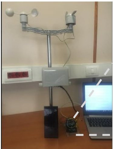 Figure 1: The Env-station hardware setup and the resulting data visualization interface.
Real-World Performance: Speed Matters
A major critique of Semantic Web technologies has often been their computational overhead. However, Wi-City-Plus proves that localized semantic queries are highly performant:
- Environmental Queries: Retrieving temperature from the nearest sensor takes a mere 20 msec.
- Traffic Routing: Calculating a dynamic, congestion-aware shortest path takes 200 msec.
The system's ability to integrate social data (user ratings and accident reports) with physical tracking data (car GPS modules) allows it to provide more accurate routing than static mapping services.
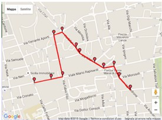 Figure 2: Execution of a SPARQL query on Google Maps interface, showing sub-30ms response times for localized data.
Deep Insight: Why This Matters for the Future
The true value of Wi-City-Plus lies in its Inductive Bias toward human-centric data. By treating "Social Data" as a first-class citizen alongside "Sensor Data," it creates a Cyber-Physical-Social System (CPSS).
While the hardware (Arduino) might feel like a prototype, the underlying logic is a blueprint for future Digital Twins. The use of an ontology ensures that as cities evolve and sensors are upgraded from 5G to 6G or beyond, the "Knowledge" of the city remains accessible and structured.
Limitations & Outlook
While the performance is impressive, the paper primarily focuses on a "small user group." Scaling this to a mega-city would require investigating Distributed RDF Stores or Semantic Stream Processing to handle the sheer volume of real-time triples. Future work should explore how this semantic layer can interface with AI agents to automate city governance.
Conclusion
Wi-City-Plus demonstrates that the Semantic Web is not just a theoretical exercise for the "Future Web," but a practical tool for modern urban engineering. By adding a layer of meaning to the mountains of city data, we can finally build platforms that don't just see the city, but understand it.