
Beyond the Map: Selective Perception in Collaborative Accessibility
Improvement in environmental accessibility via volunteered geographic information: a case study
This paper presents a case study investigating the behavior of diverse user groups (elderly, wheelchair users, visually impaired, and non-disabled volunteers) in contributing Volunteered Geographic Information (VGI) for environmental accessibility. Using a Wizard-of-Oz experimental setup, the authors identify significant differences in how these groups perceive and annotate physical barriers, revealing that non-disabled volunteers often lack the intuition to spot critical accessibility issues without specific guidance.
TL;DR
Crowdsourcing the world's accessibility is more than just marking "ramps vs. stairs." This study proves that who collects the data determines its utility. While volunteers are willing, they are often "blind" to the barriers that matter most to specific disability groups. The authors argue for a paradigm shift: from generic crowdsourcing to user-profile-aware VGI (Volunteered Geographic Information).
The "Expert-Citizen" Paradox
Building a barrier-free world is chronologically and financially expensive. We’ve turned to the crowd (VGI) to bridge the gap, assuming "the more eyes, the better." However, this paper exposes a critical flaw: Perception is not universal. A flat surface might look perfect to a sighted volunteer but lack the "tactile cues" (like lawn edges or sound landmarks) a visually impaired person needs for orientation.
Methodology: The Wizard behind the Screen
To sidestep the limitations of 2016-era GPS accuracy (which often fluctuaded by 5m+), the authors employed a Wizard-of-Oz (WoZ) setup. A hidden operator ensured 1m accuracy, triggering notifications to 36 participants as they navigated a campus route.
The Four Dimensions of Accessibility
The study forced participants to think beyond "can I pass?" by rating:
- Accessibility: Density of physical barriers.
- Safety: Risk during movement or standing.
- Effort: Physical exertion required.
- Orientation: Ease of maintaining direction.
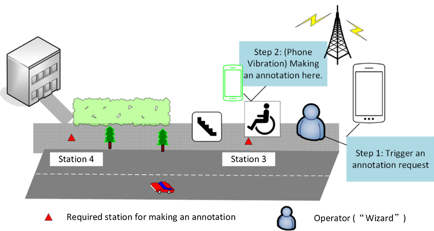 Fig 1: The WoZ experimental setup showing the operator trailing the participant to trigger data collection.
Deep Dive into the Results
The data revealed a stark contrast in "Environmental Awareness":
- Wheelchair Users werecurbstone and slope hunters.
- Visually Impaired Users uniqueley identified "Lawn edges," "Sounds," and even "Odors" as vital navigation anchors (Orientation).
- Volunteers (Non-disabled) were remarkably "active" only when prompted at stations, but "quiet" on-route. They simply didn't see the obstacles that didn't affect them.
The Rating Gap
Statistical analysis (Friedman Test) showed that volunteers gave significantly different rating values for Accessibility (p=0.01) and Orientation (p < 0.01) compared to the actual end-users. This implies that a "green" rating from a volunteer might still hide an "impassable" barrier for a wheelchair user.
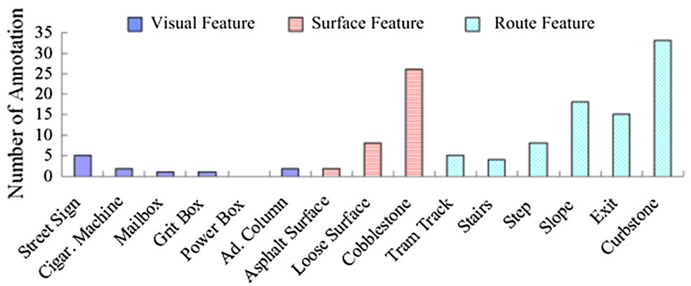 Fig 2: Distribution of annotations showing how visually impaired users prioritize Orientation, while others focus on physical barriers.
Critical Analysis & Insights
This paper hits on a fundamental issue in Human-Computer Interaction (HCI): the Empathy Gap.
The Takeaway for Developers:
- Guided VGI: Systems shouldn't just ask "Is this POI accessible?" They should provide checklists curated by O&M (Orientation & Mobility) experts.
- Task Requesting: Instead of passive collection, allow disabled users to "request" data on specific routes, focusing the crowd's energy where it's needed.
- Structured Data: Move away from unstructured text comments (which are hard for screen readers to parse) toward multi-criteria ratings that can be fed into personalized navigation algorithms.
Conclusion
The study concludes that while "Citizens as Sensors" is a powerful concept, the sensors need calibration. By integrating Orientation & Mobility expertise into the design of VGI apps, we can ensure that the "cyberspace" version of our world is as navigable as the physical one aims to be.
Limitations
The study was conducted in a controlled campus environment with a limited sample size (n=36). Future work needs to explore these dynamics in more chaotic urban environments and investigate how AI could potentially "translate" volunteer observations into useful data for specific disability profiles.