
Beyond the Map: Why Your "Inclusive" Crowdsourcing Might Be Failing its Users
Improvement in environmental accessibility via volunteered geographic information: a case study
This paper presents a case study investigating the behavior of diverse user groups (elderly, wheelchair users, visually impaired, and non-disabled volunteers) in contributing Volunteered Geographic Information (VGI) for environmental accessibility. By utilizing a "Wizard-of-Oz" experimental setup, the authors identify significant disparities in how different groups perceive and annotate urban barriers, providing a framework for improving geo-crowdsourcing systems.
TL;DR
A study published in Springer highlights a critical flaw in current crowdsourced accessibility maps: volunteers/non-disabled people perceive urban environments fundamentally differently than those they aim to help. By testing 36 participants across different disability groups, the researchers found that while volunteers are eager to help, they often miss the "invisible" barriers—like lawn edges or subtle pavement inclines—that are vital for safe navigation.
The "Anyone Can Help" Fallacy
The rise of Volunteered Geographic Information (VGI) led many to believe that the accessibility gap could be bridged by simple crowdsourcing. If enough people tag wheelchair ramps on a map, the world becomes more accessible.
However, the authors point out a harsh reality: accessibility is not a binary state. What a sighted volunteer sees as a "clear path" might be an orientation nightmare for a blind person lacking tactile cues. The study investigates the behavioral gap between four groups: the elderly, wheelchair users, visually impaired individuals, and a control group of non-disabled volunteers.
Methodology: The Wizard-of-Oz Setup
To eliminate the noise of 2016-era GPS inaccuracies, the researchers used a Wizard-of-Oz approach. A human "operator" tracked participants with 1-meter precision, triggering annotation requests on their mobile devices at specific "stations."
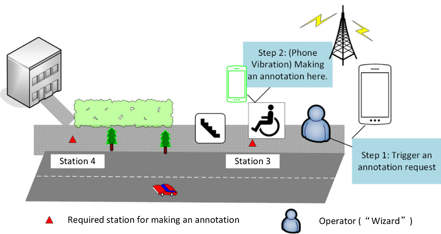
Participants rated environments based on four pillars:
- Accessibility: Presence of physical barriers.
- Safety: Perceived danger of the location.
- Effort: Physical exertion required to traverse.
- Orientation: Ease of navigating without getting lost.
The Ground Truth: Divergent Realities
The core findings reveal a massive disconnect in how these groups prioritize information.
1. Feature Prioritization
The table below shows that the "Top 1" feature varied wildly. While volunteers looked for "Loose surfaces" (mostly visual), wheelchair users focused on "Curbstones," and the visually impaired focused on the tactical utility of "Cobblestone surfaces."

2. Rating Discrepancies
The statistical analysis (Friedman Test) showed that volunteers were poor proxies for disabled users. For "Orientation," the control group's ratings were significantly different from those of the visually impaired (p < 0.01). Volunteers simply couldn't "see" what makes a space disorienting for someone with low vision.
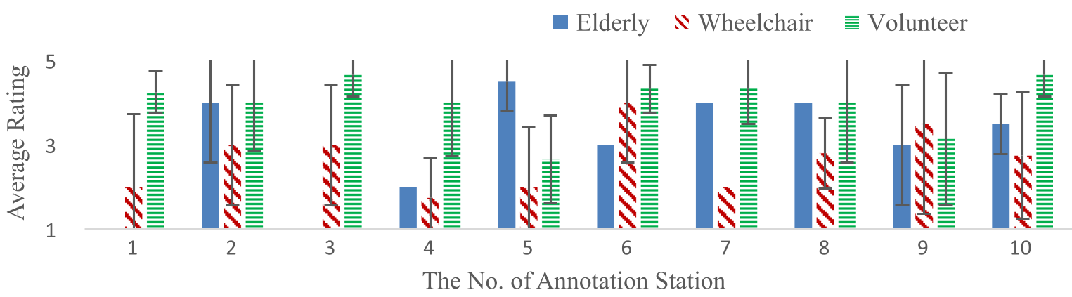
Deep Insights: How to Build Better Systems
The paper concludes with four design principles for future "Inclusive Cities":
- Guided VGI: Volunteers need "micro-training" or specific triggers. Don't ask "Is this accessible?" Ask "Is there a lawn edge or railing here for tactile navigation?"
- User-Led Requests: Instead of passive data collection, allow disabled users to request data about a specific route (e.g., "Can someone check if the elevator at Station X is working today?").
- Structured Over Unstructured: While voice notes are helpful, structured data (specific attribute ratings) is necessary for navigation algorithms to calculate personalized routes.
- Involve Experts: Orientation & Mobility (O&M) experts should design the "schemas" of what gets collected, as they understand the bridge between physical features and functional needs.
Conclusion
This study serves as a masterclass in User-Centered Design (UCD) for the physical world. It warns us that "Blind Crowdsourcing"—the act of gathering data without expert or community guidance—often results in data that is abundant but useless. To move toward truly "smart cities," we must recognize that accessibility is a personalized experience, not a general attribute.