
Turning Human Footsteps into Maps: A Smarter Approach to Indoor Crowdsourcing
Indoor Floor Map Crowdsourcing Building Method Based on Inertial Measurement Unit Data
This paper proposes an automated indoor floor map construction method using crowdsourced Inertial Measurement Unit (IMU) data from smartphones. By integrating Pedestrian Dead Reckoning (PDR) with a novel density-based trajectory filtering algorithm and Alpha-shape boundary extraction, the system reconstructs accurate indoor layouts without specialized hardware.
TL;DR
Building indoor maps is notoriously expensive and labor-intensive. This paper introduces a framework that builds these maps for free by "recycling" the IMU data from users' smartphones. By modeling how humans naturally walk in corridors (using Gaussian distributions) and applying robust density filtering, the authors can reconstruct a building's layout with up to 92% accuracy compared to real floor plans.
Problem & Motivation: The Mapping Bottleneck
In the age of GPS, outdoor navigation is a solved problem. However, once you step inside a mall or a massive office complex, you are essentially in a "black hole" of spatial data.
- The LiDAR Problem: Traditional laser scanning is precise but requires empty buildings and professional operators.
- The Sensor Problem: Smartphones have the sensors needed (IMU), but raw Pedestrian Dead Reckoning (PDR) is messy. A 100m walk typically results in a 3m drift—enough to put a user "inside a wall" on a map.
The researchers' insight was simple: Individuals are noisy, but crowds are statistical gold. By analyzing where people usually walk, the structural boundaries of a building naturally emerge.
Methodology: The Core Engine
The proposed system follows a sophisticated pipeline to transform raw sensor jitter into clean architectural lines.
1. Finding the "Knowns" (Start Point Detection)
You can't draw a map if you don't know where the pencil starts. The authors use Interest Points—locales like elevators, stairs, or entrances where IMU signatures are distinct. By using Hausdorff distance, they match real-time sensor patterns against a database of known structural features to snap the trajectory to a starting coordinate.
2. The Indoor Walking Model
This is the paper’s "Secret Sauce." The authors argue that pedestrian movement in corridors follows a Gaussian Distribution. Most people walk near the center, while fewer walk near the walls.
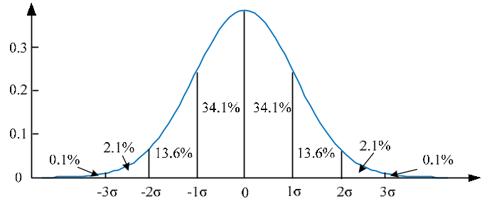
By modeling corridors as linear Gaussians and corners as multi-dimensional Gaussians, they can distinguish between "intended paths" and "sensor noise."
3. Hotspot Density Analysis
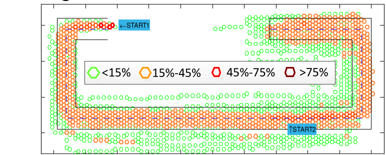
The environment is discretized into 0.3m hexagonal "hotspots."
- Weighting: Points closer to the start point are given higher weights because they have less accumulated PDR error.
- Filtering: Using an R-tree indexed "Ray Method," they calculate which hotspots are most frequented. They keep the top 70% of high-density areas and discard the rest as noise.
4. Boundary Extraction (Alpha-shapes)
Once they have a clean cloud of points representing "walkable space," they use the Alpha-shape algorithm. Think of this as a circle of radius rolling around the points; the path it carves defines the edge of the floor map.
Experiments: Does it Actually Work?
The team tested the system at the Harbin Institute of Technology. They collected 60 trajectories using 5 people and 3 different phone models.
The Key Metric: Suitability Suitability is defined as the overlap between the generated map and the ground truth:
Results Highlights:
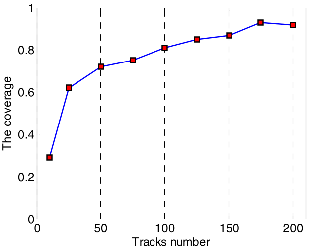
- Data Scaling: With only 50 trajectories, suitability was 72%. Once they reached 200 trajectories, suitability climbed to 92%.
- Robustness: The weighting system successfully mitigated the inherent drift of low-cost smartphone gyroscopes.
Critical Analysis & Future Outlook
The beauty of this work lies in its passive nature. It doesn't require users to "scan" a room; it simply learns from their natural walking behavior.
Limitations:
- Start Point Reliance: The system still requires known interest points (like a GPS signal dropping at an entrance) to anchor the map.
- Static Environments: It assumes the layout doesn't change. Dynamic obstacles (temporary kiosks) might be misinterpreted as walls if they persist long enough.
Future Impact: This technology paves the way for "Self-Mapping Buildings," where a facility's digital twin is constantly updated by the foot traffic of its occupants, drastically reducing the cost of indoor LBS (Location Based Services).
Conclusion
By shifting the focus from "perfect sensors" to "statistical patterns of human behavior," the authors solved a hardware problem with a software Insight. The result is a low-cost, high-accuracy alternative to expensive indoor surveying.