
Beyond Fixed Stations: Fine-grained PM2.5 Inference via Bayesian Crowdsourcing
Inferring Fine-Grained PM2.5 with Bayesian Based Kernel Method for Crowdsourcing System
This paper introduces a novel Bayesian-based kernel method for inferring fine-grained PM2.5 concentrations using a crowdsourcing system. The approach integrates heterogeneous data—including images, camera lens properties, GPS, and magnetic sensors—to overcome the low spatial density of traditional monitoring stations, achieving SOTA performance in image-based air quality estimation.
TL;DR
Researchers from BUPT have developed a crowdsourcing framework that turns ordinary smartphone photos into accurate air quality sensors. By combining Bayesian Kernel Methods with heterogeneous metadata (GPS, Magnetometer) and advanced image preprocessing, they have achieved a significant 35% reduction in prediction error compared to standard machine learning baselines, enabling high-resolution urban air quality mapping without the need for multi-million dollar monitoring stations.
The Missing Resolution in Urban Air Monitoring
While we rely on Air Quality Monitoring Stations (AQMS) for daily updates, their density is alarmingly low. In a city like Beijing, a single station represents over 400 square kilometers. Because air pollutants like PM2.5 disperse non-linearly due to traffic and urban canyons, these "official" numbers are often inaccurate for your specific street corner.
The authors identify a critical gap: existing satellite methods measure the whole atmosphere (top-down), not the air we breathe at ground level. Their solution? Image-Based Air Quality Monitoring Stations (IBAQMS) powered by the people.
Methodology: Turning Pixels into Pollutant Counts
The proposed system doesn't just look at how "blurry" a photo is. It treats the smartphone as a scientific instrument through a multi-stage pipeline:
1. The Physics of Haze
The model is grounded in the atmospheric scattering equation: Here, (medium transmission) is the key. Since PM2.5 particles have diameters close to visible light wavelengths, they cause significant diffusion. The authors extract:
- Luminance Variance: How much detail is lost between neighboring pixels.
- Saturation Gradient: How the "purity" of colors degrades in polluted air.
- Dark Channel Prior: A technique to estimate how much light is scattered by particles before reaching the lens.
2. Bayesian Kernel Regression
To handle the non-linear relationship between these features and actual PM2.5 values, the team uses a Kernel Method, projecting features into a higher-dimensional space (). The Bayesian framework allows the model to maintain "Knowledge" (prior distributions), which can be updated whenever a user is near a real station and used to infer values when they are far away.
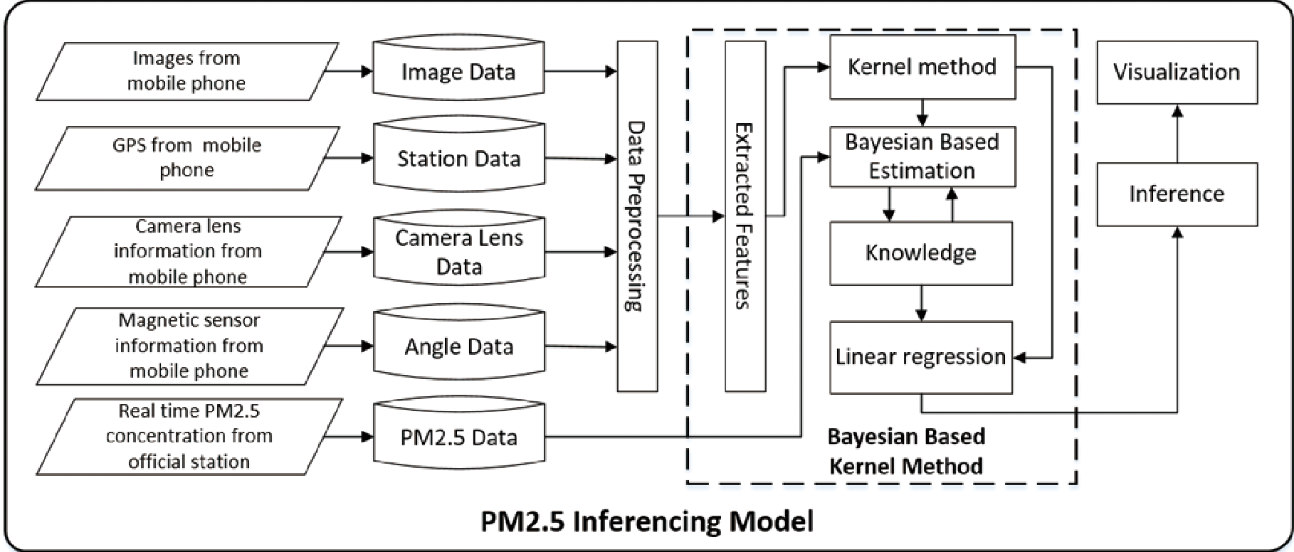 Fig 1: The overall framework integrating image registration, feature extraction, and Bayesian inference.
3. Smart Preprocessing
One of the smartest moves in this paper is the Radiometric Response correction. Different phone cameras (iPhone vs. Android) process light differently. By applying an inverse transformation, they "neutralize" the camera's internal processing, ensuring that the feature extraction reflects the atmosphere, not the phone's software.
Experimental Breakdown
The team collected 4,310 high-quality images over 16 months across 49 locations. They compared their Bayesian approach against k-Nearest Neighbors (kNN), Random Forest (RF), and Support Vector Regression (SVR).
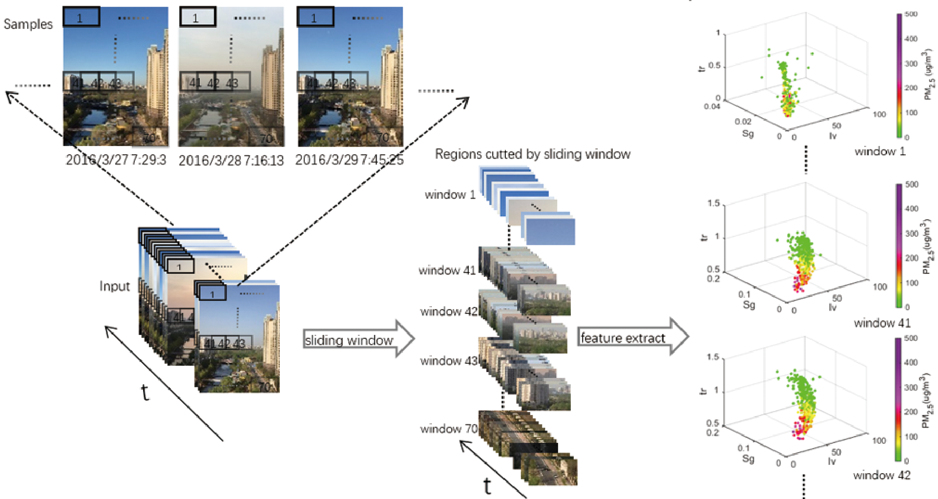 Fig 2: Visualization of how features in different "Sliding Windows" (sky vs. ground) correlate differently with PM2.5 levels.
Key Results:
- Accuracy: The Bayesian Kernel method outperformed SVR by 33.1% and RF by 26.1% in terms of Mean Absolute Error.
- Stability: The score (a measure of how well the model explains the data) increased by a staggering 304% compared to SVR, indicating a much better fit for the complex, non-linear nature of air pollution.
Critical Insight: The Power of Sliding Windows
A crucial takeaway is that not all parts of a photo are equal. Features extracted from the "sky" portions of an image often correlate more strongly with PM2.5 than the complex, shadowed "ground" portions. By using a Sliding Window (SW) approach, the model automatically weighs these regions, leading to a 23.8% improvement in accuracy.
Conclusion and Future Outlook
This paper successfully bridges the gap between digital photography and environmental science. While the current model requires some daytime photos and initial calibration, the authors suggest the next frontier is Knowledge Migration. Imagine a model trained in Beijing being deployed to a new city without any existing stations—that is the promise of this Bayesian crowdsourcing approach.
Limitations: The model is currently daytime-only and assumes a degree of scene consistency. Integrating deep learning for automatic scene segmentation could further refine feature weighting in future iterations.