
ISF: Optimizing Mobile Location Recognition through Informative Image Selection
Informative image selection for crowdsourcing-based mobile location recognition
The paper introduces the Informative Image Selection Framework (ISF), a crowdsourcing-based approach for mobile location recognition. It leverages Self-adaptive Space Clustering (SSC) and Crucial Part Feature Detection (CPFD) to select high-quality, diverse images, achieving a 5% precision improvement over baseline methods while significantly reducing storage overhead.
TL;DR
With the rise of crowdsourcing, mobile location recognition databases are becoming bloated with redundant and low-quality images. The Informative Image Selection Framework (ISF) tackles this by intelligently filtering crowdsourced data. By combining sensor-aware spatial clustering with a "Crucial Part" feature detection algorithm, ISF reduces database size while actually improving recognition precision by approximately 5% compared to standard selection methods.
The Challenge: Data Gluttony in Crowdsourcing
Mobile location recognition (identifying where you are by taking a photo) relies on high-quality reference databases. Crowdsourcing is the most scalable way to build these, but it introduces two major issues:
- Spatial Redundancy: Hundreds of users might take nearly identical photos of the same building from the same spot.
- Visual Disturbances: Photos are often cluttered with transient objects like pedestrians, cars, or changing weather conditions that confuse recognition algorithms.
For offline systems running locally on smartphones, these redundant images are a "tax" on storage and processing power.
Methodology: The ISF Blueprint
The authors propose a dual-engine approach to identify "informativeness":
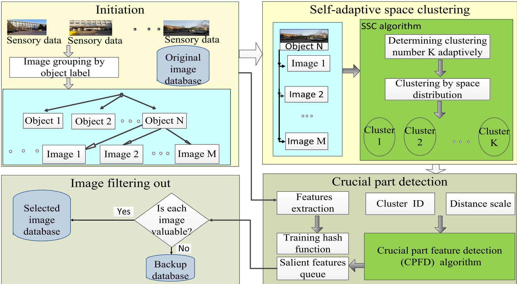
1. Self-adaptive Space Clustering (SSC)
Instead of just looking at the pixels, ISF looks at the metadata. Using the smartphone's accelerometer and magnetometer, the system calculates the shooting direction and tilt.
- Diversity: Images are grouped into clusters based on a 20° angular threshold.
- Adaptive K: The number of clusters is not fixed; it scales based on the range of shooting directions recorded for a specific object.
2. Crucial Part Feature Detection (CPFD)
Within each spatial cluster, which image is the "best"? The authors introduce the concept of Crucial Part Features (CPF).
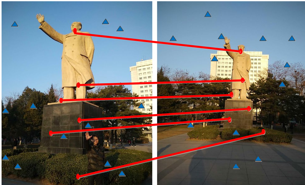
- The Intuition: Landmarks (like a statue or a facade) are "crucial" because they appear in almost every photo of that location. Pedestrians and cars are "non-crucial" because they are transient.
- The Mechanism: ISF extracts SURF features and converts them into binary hash codes using Spectral Hashing. By finding "best matching pairs" across images in the same cluster, the algorithm identifies which features are most persistent. Images with the highest count of these stable features are ranked higher.
Experimental Validation
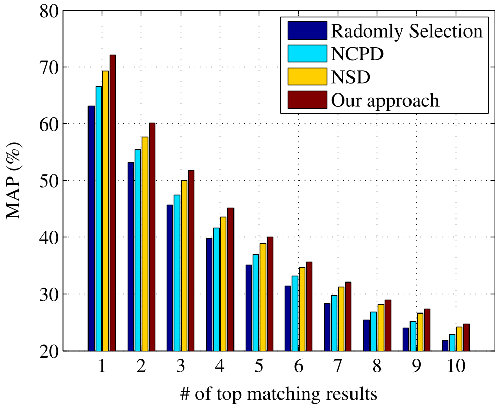
Testing on the BUPT dataset (8,062 images, 162 objects), ISF was compared against three baselines:
- NSD: No Spatial Diversity (Quality only)
- NCPD: No Crucial Part Detection (Spatial only)
- Random Selection
Key Findings:
- Efficiency: Using only 90% of the data, ISF matched the baseline of using 100% of the data.
- Accuracy: In the
MAP@N(Mean Average Precision) metric, ISF outperformed other schemes by 3-5%, proving that "less is more" when the "less" is carefully selected. - Resilience: The framework proved particularly effective when the database size was aggressively reduced (down to 10-30%), where the "informativeness" of each remaining image becomes critical.
Critical Insight & Conclusion
The brilliance of ISF lies in its sensor-augmented vision. While traditional computer vision tries to solve everything through pixel analysis, ISF uses the "physics" of the capture (spatial sensor data) to simplify the visual problem.
Limitations: The paper primarily uses SURF features and Spectral Hashing—technologies that have since been eclipsed by Deep Learning embeddings (e.g., NetVLAD or Transformers). However, the logic of using spatial metadata to guide visual selection remains highly relevant for modern edge-AI and robotics.
Future Outlook: Integrating ISF-style selection with Neural Radiance Fields (NeRF) or Foundation Models could further optimize how autonomous systems "remember" the world.