
Instagram as a Global Sensor: Mapping Urban Dynamics Through the Lens of Millions
A picture of Instagram is worth more than a thousand words: Workload characterization and application
This paper presents a comprehensive characterization of Instagram as a Participatory Sensing System (PSS). Based on 2.3 million shared photos, the authors analyze the spatial-temporal dynamics of user behavior and propose a methodology to identify urban Regions of Interest (ROI) and tourist landmarks with SOTA-level precision.
TL;DR
This research redefines Instagram not just as a social network, but as a sophisticated Participatory Sensor Network (PSN). By analyzing 2.3 million geotagged photos, the authors uncover how human "sensing" behavior reflects cultural rhythms and urban structures, providing a blueprint for identifying city hotspots and landmarks without traditional sensor infrastructure.
Problem & Motivation: Beyond Traditional Sensors
For decades, urban sensing relied on static Wireless Sensor Networks (WSNs) which are expensive, prone to hardware failure, and geographically restricted. The emergence of Participatory Sensing Systems (PSS) leverages the smartphone in every pocket.
However, the challenge lies in the "Human Element." Unlike calibrated sensors, humans are unpredictable. We share photos unevenly, favor tourist spots over supermarkets, and follow cultural routines. The authors sought to understand these biases to transform "noisy" social media data into actionable urban intelligence.
Methodology: The Logic of Human Sensors
The study treats each Instagram post as a data point defined by its {latitude, longitude, timestamp}. The core methodology involves two distinct scales of analysis:
- Spatial Grid Analysis: The city is divided into quadrants (approx. 10x11m). By applying a Power Law distribution analysis, the researchers found that while coverage is global, density is extremely localized—a few "super quadrants" account for the majority of data.
- Point of Interest (POI) & Landmark Identification:
- Clustering: Using the Complete-Linkage method, they grouped coordinates within 250m.
- De-noising: They compared actual cluster densities against a random null model (Normal Distribution) to filter out occasional or private activity (like homes).
- Graph Theory for Landmarks: By building a transition graph of user movements between clusters and filtering low-weight edges, they isolated the "tourist paths" that define a city's cultural identity.
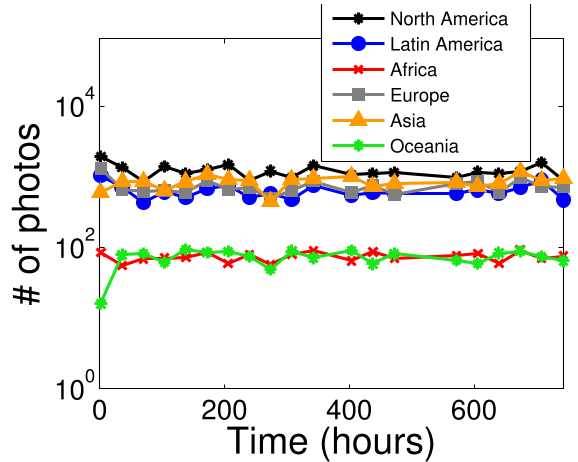 Figure 1: Conceptualizing the transition from individual photo shares to a structured Participatory Sensor Network (PSN).
Experiments & Results: Cultural Signatures
The findings highlight a fascinating "Cultural Signature" in the data. For instance:
- Seasonality: Brazilian users show intense activity late at night (the "Happy Hour" effect), whereas Japanese and Spanish users exhibit sharper peaks strictly aligned with traditional lunch and dinner hours.
- Node Behavior: The discovery of "Super Nodes"—users who travel long distances and post frequently—suggests that a small percentage of participants provide the most valuable "sensing" coverage for a city.
- ROI Accuracy: In Belo Horizonte, the algorithm's identified landmarks matched 87.5% of official TripAdvisor recommendations.
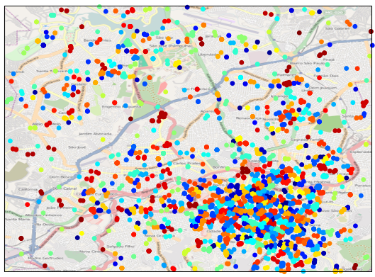 Figure 2: The evolution of data processing from raw coordinate clusters (a) to filtered Points of Interest (b) and finally to identified cultural Sights (c).
Critical Analysis & Conclusion
Takeaway
Instagram photos are "worth more than a thousand words" because they provide metadata that effectively maps the "Vibe" of a city. The temporal sharing patterns of different venues—stadiums (event-oriented) vs. malls (continuous)—allow for automated classification of urban spaces.
Limitations & Future Work
The study acknowledges two major hurdles:
- The Zero-Sensing Problem: Many quadrants have zero activity at any given minute, making real-time monitoring difficult without incentives (like micro-payments).
- Digital Divide: Cities like Cairo show significantly lower participation compared to New York, highlighting that PSS effectiveness is tied to local smartphone penetration and data costs.
Future research plans to integrate cross-platform data (e.g., Waze and Weddar) to create a multi-dimensional "Digital Twin" of urban environments.
Editor's Note: This paper is a seminal look at how social media serves as an accidental but high-fidelity proxy for urban planning and sociological research.