
SIGMA: Leveraging Cultural Algorithms to Navigate the Safety Landscape of Ciudad Juárez
Intelligent Application to Reduce Transit Accidents in a City Using Cultural Algorithms
The paper introduces SIGMA, an intelligent mobile application designed to reduce traffic fatalities in Ciudad Juárez by predicting accident risks. It leverages a hybrid approach combining Cultural Algorithms and Data Mining to provide real-time safety indices and alternative route suggestions to drivers.
TL;DR
Researchers have developed a mobile intelligent system called SIGMA that predicts the likelihood of traffic accidents in real-time. By combining Cultural Algorithms and Data Mining, the system provides drivers in Ciudad Juárez with a color-coded risk map, leading to a 28% improvement in suggestion accuracy over standard data analysis methods.
Context: A City Under Pressure
Ciudad Juárez is a critical hub at the Mexico-U.S. border, but it faces a grim statistic: traffic accidents are the second leading cause of death. Between 2008 and 2012, nearly 4,000 people lost their lives on the road. While most GPS apps optimize for time, SIGMA (Mobile Geographic Information System) optimizes for survival.
The Core Challenge: Predicting "Danger"
Why is predicting an accident so hard? Accidents aren't just random; they are clusters of spatial-temporal variables. Prior work often ignored the "time-of-arrival" security or failed to suggest alternative paths based on evolving danger levels. The researchers identified that a static database isn't enough—you need an algorithm that "learns" the culture of the city's traffic.
Methodology: The Hybrid Intelligence
The technical backbone of SIGMA relies on two main pillars:
1. The Haversine Foundation
To determine if a user is near a high-risk zone, the system uses the Haversine formula to calculate great-circle distances between the user's GPS coordinates and historical accident points on a sphere.
2. The Traffic Insecurity Index
Inspired by the UN's Human Development Index (HDI), the researchers created a composite index:
- Component Q (Quantity): Measures the density of events in a specific radius.
- Component H (Hour): Weights the risk based on the time of day (e.g., rush hour vs. midnight).
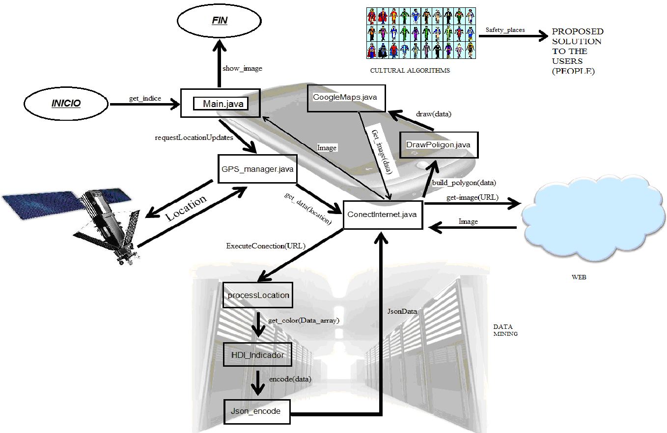 Fig 1. High-level operation of the SIGMA system involving mobile-server communication.
3. Cultural Algorithms (CA)
Cultural Algorithms mimic the process of cultural evolution. In this context, the "culture" is the collective information about traffic hazards. The algorithm uses a "belief space" to store the best solutions (safest routes) found by "individuals" (data points/simulations), which then influences the search parameters for future route suggestions.
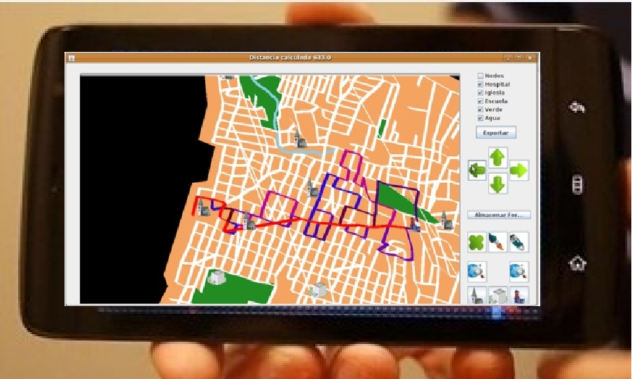 Fig 2. The intelligent tool recommends alternative routes after processing accident data.
Experiments and Results: Does it Work?
The effectiveness of the system was measured in "époques" (time periods of algorithmic evolution). The researchers compared three approaches:
- Random Action: baseline safety.
- Pure Data Mining: basic statistical alerts.
- Hybrid CA + DM: the proposed intelligent model.
The verdict: The hybrid approach was the clear winner. It outperformed pure data mining by 28%, providing far more accurate safety suggestions to the users. It didn't just show where accidents happened; it predicted where they were likely to happen based on current temporal contexts.
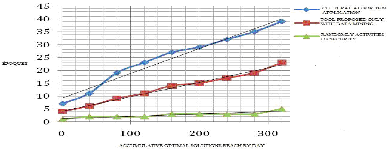 Fig 3. Performance of the hybrid approach (blue) vs. pure data mining (red) and random (green).
Critical Insight & Future Outlook
The brilliance of this work lies in its dynamic maximums. For example, if a specific avenue (like Cuatro Siglos Avenue) becomes more dangerous, the algorithm adjusts its "maximum danger" threshold in real-time.
Limitations: The current model depends heavily on the quality of the government's transit database. If reporting is delayed, the real-time aspect suffers.
The Future: The authors plan to expand this into an "Intelligent Diorama" for social networks and apply the logic to other high-risk urban problems, such as predicting carjackings using even more advanced bio-inspired models like the Bat Algorithm.
Takeaway
By shifting the focus from "fastest route" to "safest route" through Cultural Algorithms, technology can move from being a convenience to a critical life-saving intervention in metropolitan environments.