
Intelligent Geo-Conquesting: Transforming Smart City Crowdsourced Data into Market Insights
IT GOVernanCe anD manaGemenT anD manaGemenT anD manaGemenT anD manaGemenT anD manaGemenT Intelligent Marketing in Smart Cities Crowdsourced Data for Geo-Conquesting IT In SmarT CITIeS
The paper introduces an intelligent marketing framework for smart cities that utilizes large-scale mobile crowdsourced data for geo-conquesting. It proposes a distributed Local Longest Common Subsequence (LLCS) clustering method to analyze complex user trails and identify crowd flow patterns and hotspots.
TL;DR
This paper presents a robust architecture for "geo-conquesting"—an aggressive marketing strategy—by analyzing massive streams of mobile user trails. By leveraging a distributed Local Longest Common Subsequence (LLCS) clustering method, the system identifies crowd flows and hotspots, enabling marketers to hyper-target consumers in real-time. The approach achieves a 63x speedup in data processing, making the analysis of trillions of data points feasible for smart city applications.
Problem & Motivation: The Data Deluge in Smart Cities
With the proliferation of IoT devices and smartphones, smart cities have become massive sensor networks. However, most existing location-aware technologies (like geo-fencing) focus on simple proximity: if a user enters a zone, send an ad.
The authors identify two critical gaps:
- Lack of Continuity: Most systems look at discrete "check-ins" rather than the continuous path (time-series trails) of a user.
- Computational Scaling: Analyzing the similarity between trillions of potential user trajectories is computationally prohibitive using standard sequential algorithms.
- Indoor Limitations: Traditional GPS fails indoors, necessitating a methodology that can integrate diverse data sources like BLE (iBeacon) or Wi-Fi to maintain accuracy.
Methodology: Distributed LLCS and Centroid-Free Clustering
The core of the paper lies in its ability to handle "mega-crowdsourced" data through a two-stage process: Trajectory Projection and LLCS-Based Clustering.
1. The Distributed Framework
The system divides a city or mall layout into discrete "blocks." When a user trail is received, a dispatcher segments the sequence and assigns it to a specific machine in a cluster based on the geographical block it falls into.
2. Similarity and Clustering
To compare two trail segments and of different lengths, the authors use a modified Longest Common Subsequence (LCS) formula:
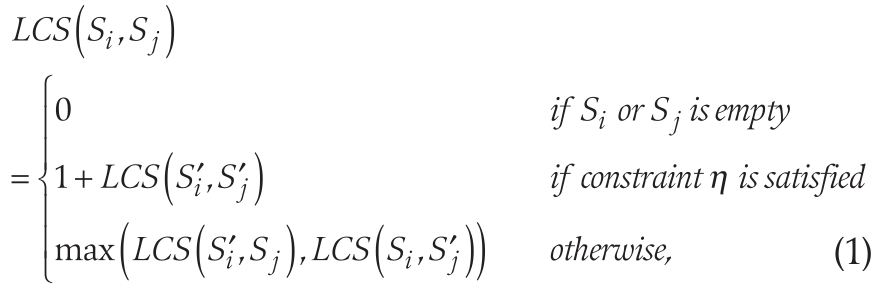
Instead of traditional K-means, which requires a "mean" or "centroid" (difficult to define for complex spatial sequences), the authors employ a centroid-free K-means approach. This calculates similarity based on the pairwise distances of all segments within a cluster, defined by:
3. Transition Modeling
By quantizing directions into eight primary angles (0° to 315°), the system calculates "In-trails" and "Out-trails" for each cell, allowing it to predict where a crowd is likely to move next.
Experiments & Results: Massive Speedup
The authors conducted simulations involving 50 trails, each averaging 1,600 coordinate pairs. The results validate the efficiency of the distributed mechanism.
- Single Machine: High latency due to the nature of pairwise comparisons.
- 16-Block Distribution: Achieved a 63x speedup, proving that the bottleneck of trajectory analysis can be overcome by localized, parallel processing.
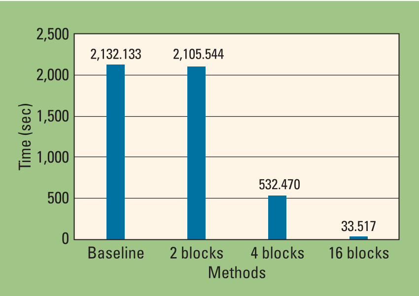 Figure: Computational performance comparison showing the dramatic reduction in processing time as the number of distributed blocks/machines increases.
Critical Analysis & Conclusion
The value of this work is its shift toward the marketer’s perspective. While most apps focus on the user experience, this system provides a "God-view" of city or mall dynamics.
Key Takeaways:
- Geo-Conquesting Power: By identifying where customers of a rival brand are walking, a store can deploy digital billboards exactly in the path of that crowd.
- Operational Efficiency: Mall operators can use these heatmaps to justify higher rental prices for "high-transition" blocks or redesign traffic flows to revitalize "dead zones."
Limitations & Future Work:
While the 63x speedup is impressive, the paper primarily uses simulated data for its performance metrics. Real-world indoor data is often noisier (signal drift). The authors suggest that future work should focus on optimizing the "Quality of Experience" (QoE) for customers to ensure that "hyper-targeting" doesn't become "hyper-annoying."
In conclusion, this paper provides a scalable blueprint for turning the "smart city sensor network" into a high-precision engine for commercial strategy.