
Itinerary Planning 2.0: Bridging Social Vibe with Physical Flow
Intention oriented itinerary recommendation by bridging physical trajectories and online social networks
The paper introduces an intention-oriented itinerary recommendation framework that bridges physical vehicle trajectories with Location-Based Social Networks (LBSN). It utilizes the Ant Colony Optimization (ACA) algorithm to provide flexible, multi-objective travel plans based on user "intentions" (categories) rather than fixed destinations, achieving an average user satisfaction rate of 80%.
TL;DR
Most travel apps expect you to know exactly where you are going. This paper presents a framework for those who don't. By merging Foursquare's social popularity data with real-world taxi GPS trajectories, the authors created a system that recommends itineraries based on intentions (e.g., "I want a snack, then a park") rather than specific addresses, optimizing for both "the best spots" and "the least traffic."
The Problem: The "Stranger's Dilemma"
When you visit a new city like Beijing, you don't know the name of the best hidden duck restaurant; you just know you want "authentic Chinese food." Current systems fail because:
- Vague Input: Users describe needs as categories, not coordinates.
- Static Traffic: Traditional GIS calculates distances, not the actual "pain" of cross-city travel during rush hour.
- Popularity vs. Proximity: A nearby restaurant might be terrible, while a great one might be across town. Balancing these is a classic Multi-Objective Optimization problem.
Methodology: The Semantic Bridge
The authors address this by building a bridge between two worlds:
1. The Physical World: Voronoi-based Traffic Maps
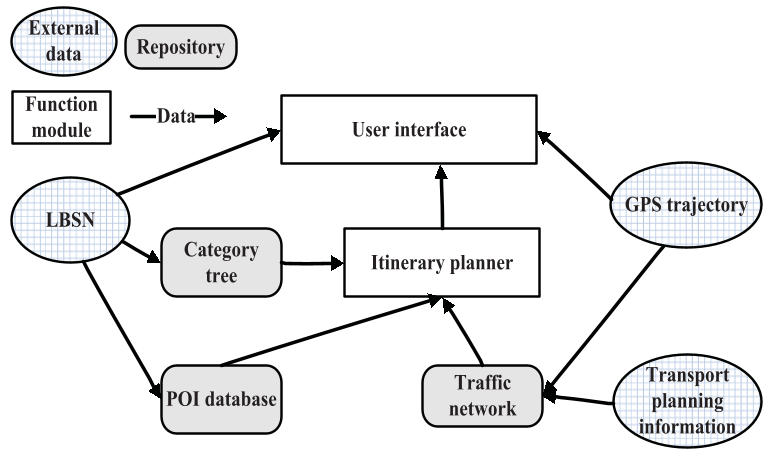
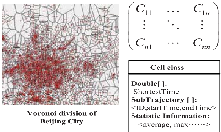
To understand how a city actually moves, the research uses 10,000+ taxi trajectories. Instead of raw GPS points, they use a Voronoi Diagram anchored to public bus stops. This transforms the city into a "Semantic Map" where every coordinate belongs to a known landmark/stop, making computation efficient and human-readable.
2. The Social World: Foursquare Intentions
By crawling Foursquare, the system builds a hierarchy of POIs. If a user asks for "Fast Food," the system looks at the top-ranked POIs in that category based on "Check-in" counts, ensuring quality.
3. The Brain: Modified Ant Colony Optimization (ACA)
To find the perfect trip, the authors use an Ant Colony Algorithm.
- Pheromones: Represent the "shortcut" efficiency (travel time).
- Heuristic Rules: Represent the "popularity" of the destination. The "ants" traverse different POI categories, leaving stronger trails on paths that are both fast and popular. This avoids the "Combinatorial Explosion" where checking every possible combination of restaurants and malls would crash a server.
Experiments & Results: Real-world Beijing
The system was tested on the GeoLife and T-drive datasets.
| Parameter | Result |
|---|---|
| Datasets | 10,357 Taxis, 30,784 Foursquare POIs |
| User Satisfaction | 80% Average |
| Efficiency | ACA solved 6-activity trips significantly faster than Baselines |
The results showed a fascinating trade-off. While the "Baseline" algorithm found the absolute shortest travel time (11 mins for a specific trip), it often recommended boring or less popular locations because they were geographically clustered. The Ant Colony approach took slightly longer (25 mins) but recommended significantly more "famous" spots, leading to higher human satisfaction scores (8.2 vs 7.4).
Critical Analysis & Conclusion
The Takeaway
The genius of this paper lies in the Semantic Point concept. By mapping chaotic GPS data to social landmarks via Voronoi cells, it creates a common language for "where we are" and "where we want to be."
Limitations
- Dynamic Content: The 2012-era Foursquare data is static; today's users might demand real-time "Current Occupancy" or "Instagram-ability."
- Transport Modes: The traffic model is heavily reliant on Taxis, which might not reflect the experience of someone using the Beijing Subway.
Future Outlook
In the age of LLMs, this framework provides a solid backbone. Imagine a GPT-4 agent using this ACA logic to not just "chat" about a trip, but to verify it against real-time physical traffic data. That is the future of the "Intelligent Concierge."