
Scaling Regional Excellence: High-Resolution Land Cover Mapping via Multisource Integration
International Journal of Applied Earth Observation and Geoinformation
The paper proposes an operational regional land cover mapping approach that integrates multisource data including phenology-contrasted multispectral bands, biophysical indices (GDVI, LST), and topographic features. By comparing traditional and machine learning classifiers, it identifies that a Maximum Likelihood (ML) classifier combined with subclass-level sampling achieves SOTA-level accuracy (94.2%–96.4%) while maintaining high computational efficiency for large-scale datasets.
TL;DR
Researchers have developed a high-efficiency workflow for regional land cover mapping that prioritizes feature dimension expansion over classifier complexity. By integrating 13 bands of phenology-contrasted spectral, biophysical, and topographic data, the team achieved over 94% accuracy using a standard Maximum Likelihood classifier, completing in minutes what takes advanced machine learning models (SVM/RF) several days.
The "Complexity-Efficiency" Paradox in Remote Sensing
In the era of high-resolution satellite imagery (like Landsat 8), we face a dual challenge:
- Landscape Complexity: In Mediterranean regions, "Olives," "Woodlands," and "Rangelands" often intergrade, creating "mixed pixels" that are spectrally indistinguishable in a standard 3-band or 6-band space.
- Scalability Walls: While Support Vector Machines (SVM) and Random Forests (RF) are the darlings of local-scale classification, their processing time scales poorly. A process taking 20 minutes for a small subset can explode into a 5-day ordeal for a single regional scene.
The authors' insight was simple yet profound: If we can make the classes "linearly separable" through better features, we don't need a heavy-duty non-linear classifier.
Methodology: The 13-Dimensional Feature Space
The core innovation lies in the progressive integration of multisource data. The researchers didn't just look at one "perfect" image; they looked at the heartbeat of the landscape through time (Phenology).
The Feature Stack:
- Phenology Contrast: Using both Spring (growth peak) and Summer (dormancy) multispectral bands (MS 1, 4, 7).
- Biophysical Indicators: The Generalized Difference Vegetation Index (GDVI) for dryland precision and Land Surface Temperature (LST).
- Topography: Elevation, Slope, and Aspect (derived from SRTM DEM).
 Figure 1: Conceptual workflow of the multisource integration and classification comparison.
By expanding the feature space, the Jeffreys-Matusita Distance (JMD)—a measure of class separability—jumped from a confusing 1.10 (indicating high overlap) to a decisive 1.94 (indicating nearly complete separability).
Experiments: ML vs. The "Black Boxes"
The study compared five algorithms: Mahalanobis Distance (MD), Maximum Likelihood (ML), Artificial Neural Networks (ANN), SVM, and RF.
Key Findings:
- Accuracy: SVM and RF are indeed the "Gold Standard" for accuracy at a local subset level (reaching ~96.9%).
- The Bottleneck: At the whole-scene scale (approx. 7156 x 6858 pixels), SVM and RF failed to finish within the 5-day testing window.
- The Winner: The ML classifier, given the 13-band integrated dataset, achieved an Overall Accuracy (OA) of 95.26% and completed the task in just 10 minutes.
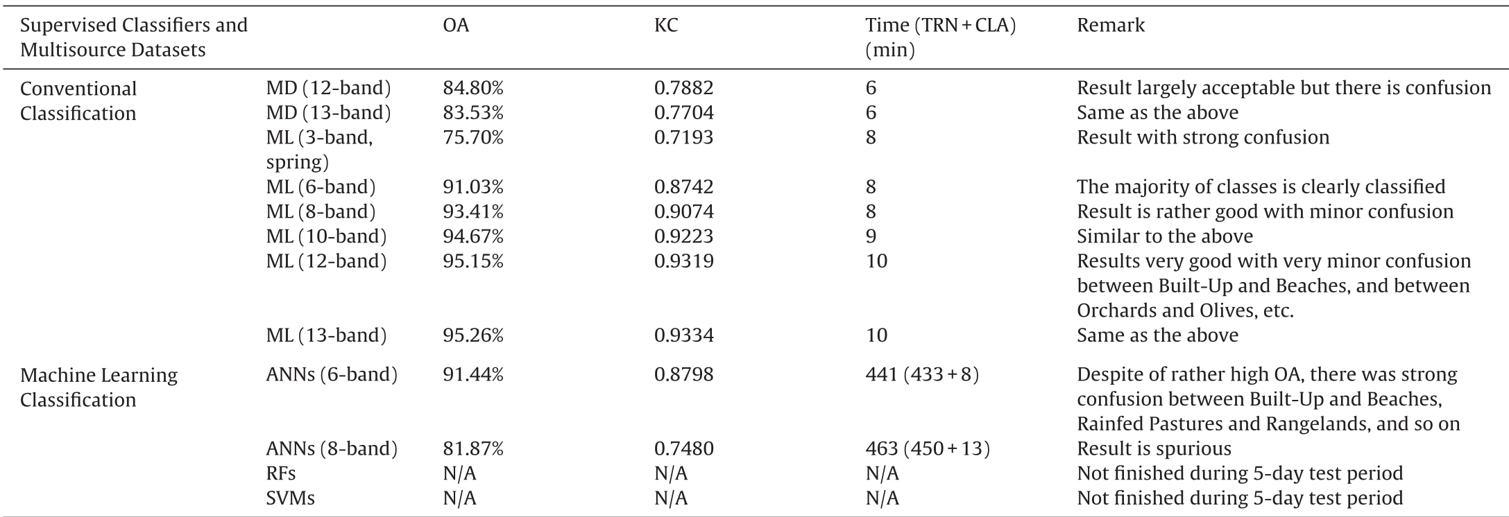 Table: Comparison of classification time and accuracy across different models. Note the "N/A" for RF and SVM due to unacceptable processing time at scale.
Visual Evidence of Performance
The resulting maps show high fidelity even in complex terrains where traditional methods usually fail to distinguish between terraced olives and natural shrublands.
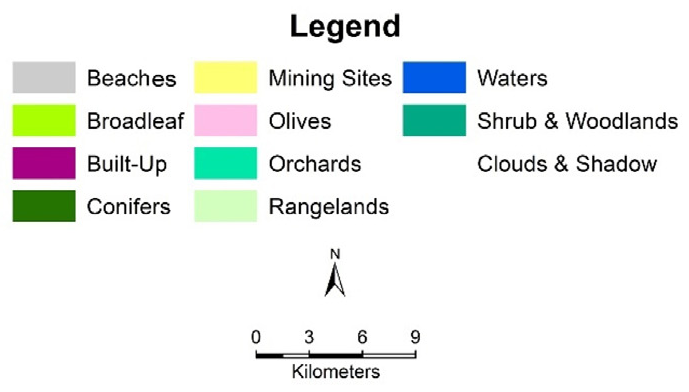 Figure 2: Visual comparison of (c) Random Forests, (d) Maximum Likelihood, and (e) SVM results. The ML result (d) shows nearly identical spatial patterns to the more complex models but at a fraction of the cost.
Critical Insight: Subclass Sampling
Beyond the 13 bands, the authors used a technique of subclass sampling. Instead of just "Olives," they sampled "Olive 1" (on brown soil) through "Olive 5" (mature groves with high canopy). This addressed the "non-parametric" nature of land cover in complex terrains, allowing the simple ML classifier to handle multimodal distributions within a single broad class.
Conclusion & Future Outlook
This paper serves as a tactical handbook for regional-scale mapping. It proves that Operationality = Accuracy + Efficiency.
While the AI world rushes toward deeper and more complex models, this research reminds us that in Geospatial Data Science, domain-driven feature engineering (like selecting the right phenological windows) remains the most potent tool for scaling insights across continents. Future work will likely see these 13-band stacks being used to pre-train lightweight "Edge-AI" models for real-time satellite monitoring.
Takeaway: Don't use a sledgehammer (SVM) to crack a nut when you can just sharpen your knife (Feature Engineering).