
JustWalk: Revolutionizing Indoor Mapping through Crowd-Sourced Motion Anchors
JustWalk: A Crowdsourcing Approach for the Automatic Construction of Indoor Floorplans
JustWalk is a crowd-sensing system for the automatic construction of indoor floorplans using ubiquitous smartphone sensors. It leverages a novel anchor-based error resetting technique and image processing to generate semantic-rich layouts without explicit user interaction, achieving high accuracy in POI detection and trajectory refinement.
TL;DR
JustWalk is an autonomous indoor mapping system that turns regular walking patterns into high-fidelity floorplans. By leveraging smartphone sensors to detect hidden environmental "anchors" (like the magnetic signature of an elevator or the barometric change of a staircase), it solves the critical "drift" problem in dead-reckoning, achieving a 12x improvement in accuracy over traditional methods—all without requiring users to take a single photo.
Background & Motivation: The Indoor Map Gap
While GPS has mastered the outdoors, the "Indoor Frontier" remains largely unmapped. Giant providers like Google Maps cover only a fraction of global buildings because manual mapping is slow, expensive, and privacy-invasive.
The technical heart of the problem is Inertial Drift. If you track a person’s movement using only an accelerometer, noise accumulates rapidly, leading to distance errors of 100 meters in just one minute. Previous crowdsourcing attempts required users to take photos (Jigsaw) or record video (CrowdMap), which are obtrusive and unlikely to scale. JustWalk asks: Can we build the map using only the passive sensors already running in our pockets?
Methodology: The Architecture of Transparent Sensing
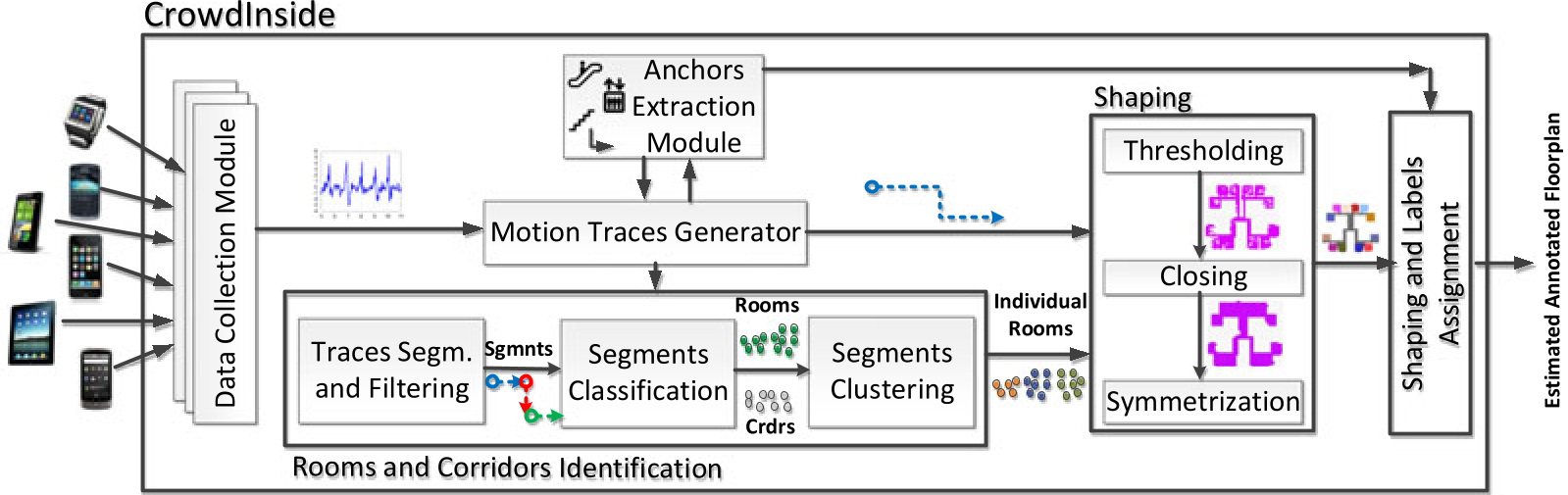
JustWalk’s secret sauce is its Anchor-Based Error Resetting. The system doesn't just blindly follow the IMU; it looks for "landmarks" in the sensor data stream.
1. The Traces Generation Module (How it tracks)
The system uses a sophisticated dead-reckoning approach (UPTIME) but corrects it periodically. When a user hits an "Anchor Point"—a unique physical feature like a turn, an elevator, or an electronic machine—the system detects its signature and resets the accumulated displacement error to zero.
2. The Floorplan Estimation (How it draws)
Once accurate traces are collected, JustWalk treats them as a Point Cloud. It applies a three-step image processing pipeline:
- Thresholding: Converting step counts into binary grid cells (Walkable vs. Blocked).
- Closing: Using morphological operators to fill gaps caused by unvisited areas.
- Symmetrization: A brilliant insight—most buildings are symmetric. The system uses SIFT features to detect axes of symmetry and "mirrors" missing data to complete the floorplan.
3. Detailed Semantic Labeling
It doesn't just draw boxes. By analyzing WiFi signal attenuation and step intervals, JustWalk classifies segments into Rooms or Corridors and identifies door locations through the intersection of these segments.

Experimental Results: Precision at Scale
The researchers tested JustWalk across three distinct environments (Railway stations and University campuses).
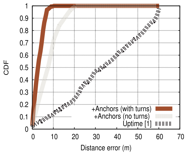
- Drift Correction: The anchor-resetting mechanism achieved a 12x enhancement in median distance error compared to standard pedestrian tracking.
- POI Accuracy: Vertical movement anchors (stairs/elevators) were detected with near-perfect accuracy (only 0.6% false positives).
- Efficiency: An accurate map of a station platform could be generated from just ~800 traces—a tiny fraction of the daily foot traffic in a major city like Osaka.
Deep Insights & Future Outlook
Why it works: JustWalk succeeds by embracing the "Simultaneous Localization and Mapping" (SLAM) philosophy. It recognizes that identifying the map and localizing the user are codependent; as more users "detect" the same elevator, the elevator's location becomes a fixed reference for all future users.
Limitations: The system's quality depends on "popular" areas. A room that is never visited remains a hole in the map. Furthermore, while it handles multi-floor buildings via barometer data, highly complex architectural styles without clear symmetry might still pose challenges for the refined shaping module.
The Takeaway: JustWalk proves that the future of indoor LBS (Location Based Services) doesn't need expensive infrastructure (Beacons/UWB). By "Just Walking," users can collectively illuminate the dark interiors of our world's buildings, one step at a time.