
Towards Resolving the Kidnapped Robot Problem: A Social & Cloud Approach
Towards Resolving the Kidnapped Robot Problem: Topological Localization from Crowdsourcing and Georeferenced Images
The paper introduces a novel topological localization framework to solve the "Kidnapped Robot Problem" by leveraging crowdsourcing and georeferenced web data. The method utilizes social media interaction (Twitter) and image matching against GPS-tagged databases (Flickr) to re-establish a robot's global position and plan a return path to its home coordinates.
TL;DR
The "Kidnapped Robot Problem" — where a robot is dropped into a random, unmapped location — is a classic robotics nightmare. This paper proposes a "socially-assisted" solution: the robot takes a picture, asks Twitter where it is, uses the reply to find georeferenced photos on Flickr, and matches its current view to these photos to find its GPS coordinates and navigate home.
Background positioning
In the landscape of robot localization, most researchers focus on improving internal filters (like Particle Filters or EKF-SLAM). This paper takes a radical departure by positioning itself within the realm of Cloud Robotics. It treats the internet and human crowds as an infinite sensory external database, moving beyond the limitations of local on-board sensors.
Problem & Motivation: The Localization Blind Spot
The fundamental pain point of current localization is the "cold start." If a robot loses its track (kidnapping), it has no context to re-align its internal map.
- Prior Work Limitation: Methods like Monte Carlo Localization (MCL) rely on huge particle sets that can be computationally expensive and often fail if the initial guess is too far off.
- The Insight: Humans solve this by asking. Why shouldn't robots? By mimicking human social behavior, a robot can gain a "semantic leap"—knowing it is at "The University of Nebraska" allows it to narrow down billions of possibilities to a few dozen images.
Methodology: Social Interaction and Temporal Filtering
The core architecture consists of two main loops: the Social Query and the Visual Verification.
1. The Twitter-Flickr Pipeline
The robot uses a MATLAB interface to post snapshots of its surroundings to a dedicated Twitter account. Once a human responds with a landmark name, the robot queries Flickr for GPS-tagged images matching that name.
2. Temporal Sensitivity Functions
Environment appearance changes drastically with time and seasons. To solve this, the author introduces an exponential weighting mechanism for the retrieved images:
- Date Weight (): Prefers recent images over old ones.
- Time Weight (): Matches images taken at similar times of day (e.g., noon vs. night).
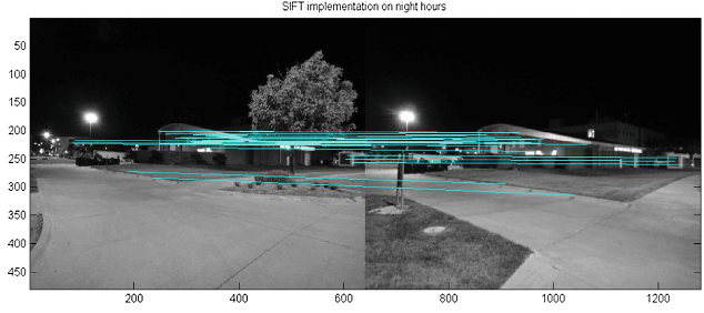 Figure: The flow of steps from Twitter query to Flickr search and final GPS extraction.
3. SIFT Matching
The robot uses SIFT (Scale-Invariant Feature Transform) to compare its current view with the downloaded georeferenced images. If a match occurs, the robot "inherits" the GPS coordinate of that image.
Experiments & Results: Real-world Validation
Testing was performed using a Corobot mobile robot on the University of Nebraska campus.
- Accuracy: The robot successfully identified four key waypoints (A, B, C, D) along its path home.
- Visual Evidence: The matching was most effective at landmarks with clear architectural features. Interestingly, the research noted that lower resolution images (640x480) produced stronger descriptors and faster processing (approx. 3s per match).
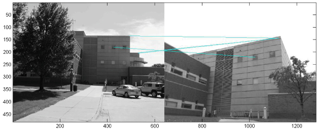 Figure: The red line indicates the path traversed by the Corobot, with letters A-D marking successful cloud-based localizations.
Critical Analysis & Conclusion
Takeaway: This paper successfully demonstrates that the "Kidnapped Robot Problem" doesn't have to be solved in a silo. By utilizing crowdsourcing and georeferenced web data, robots can handle total localization failure in unstructured environments.
Limitations:
- Latency: Relying on human responses on Twitter is not "real-time."
- Social Dependency: The method requires an active internet connection and a helpful social network.
- Obstacle Avoidance: The current path planning is a simple Euclidean node-to-node jump, ignoring local obstacles.
Future Outlook: The logical next step—and one the author hints at—is replacing the human crowd with an AI/VLM (Vision Language Model). Imagine a robot using a model like GPT-4o to identify the landmark autonomously, then performing the same georeferenced search on the web. This would combine the "Social Insight" of this paper with the "Autonomous Speed" required for production robotics.