
KikuNavi: Solving the "Blind Spots" of GPS with Human Collective Intelligence
KikuNavi: Real-time pedestrian navigation based on social networking service and collective intelligence
KikuNavi is a real-time pedestrian navigation system that leverages Social Networking Services (Twitter) and collective intelligence to assist lost users. By connecting "requesters" with human "navigators," it provides personalized guidance through live location tracking (Direct Navigation) or manual route sketching (Sketch Navigation), surpassing the limitations of traditional GPS-based systems.
TL;DR
KikuNavi is an innovative social navigation system that solves the common frustrations of modern GPS: it works where maps don't exist, understands vague requests like "I'm hungry for something sweet," and adapts to real-time changes. By linking lost users with human navigators via Twitter, it uses a simple direction arrow and route sketching to provide intuitive, human-powered guidance.
The Motivation: Why Google Maps Isn't Enough
We have all been there: your GPS pin is jumping around inside a massive train station, or you're looking for a specific food stall at a festival that isn't on any digital map. The authors of KikuNavi identify three fatal flaws in current navigation tech:
- The Map Gap: No data for building interiors or temporary event spaces.
- The Query Gap: Machines struggle with intent-based queries ("a place to play soccer").
- The Static Gap: Maps don't know that a specific entrance was closed five minutes ago due to a spill or construction.
KikuNavi’s core insight is simple: Local people know better than static databases.
Methodology: Social-Powered Pathfinding
The system operates as a bridge between two roles: the Requester (who is lost) and the Navigator (who knows the way).
The Workflow
- The Request: The user enters a destination (specific or vague) into the KikuNavi app.
- The Social Broadcast: The app automatically generates a Twitter post with the hashtag
#KikuNavi. - The Connection: A "friend" or a helpful stranger clicks the link in the tweet to enter the navigation cockpit.
Interaction Modes
- Direct Navigation: The navigator literally "leads" the user. The requester’s phone displays a large arrow pointing toward the navigator's real-time GPS coordinates.
- Sketch Navigation: Ideal for long-distance help. The navigator taps out a path on their screen, which appears as a custom route on the requester’s device.
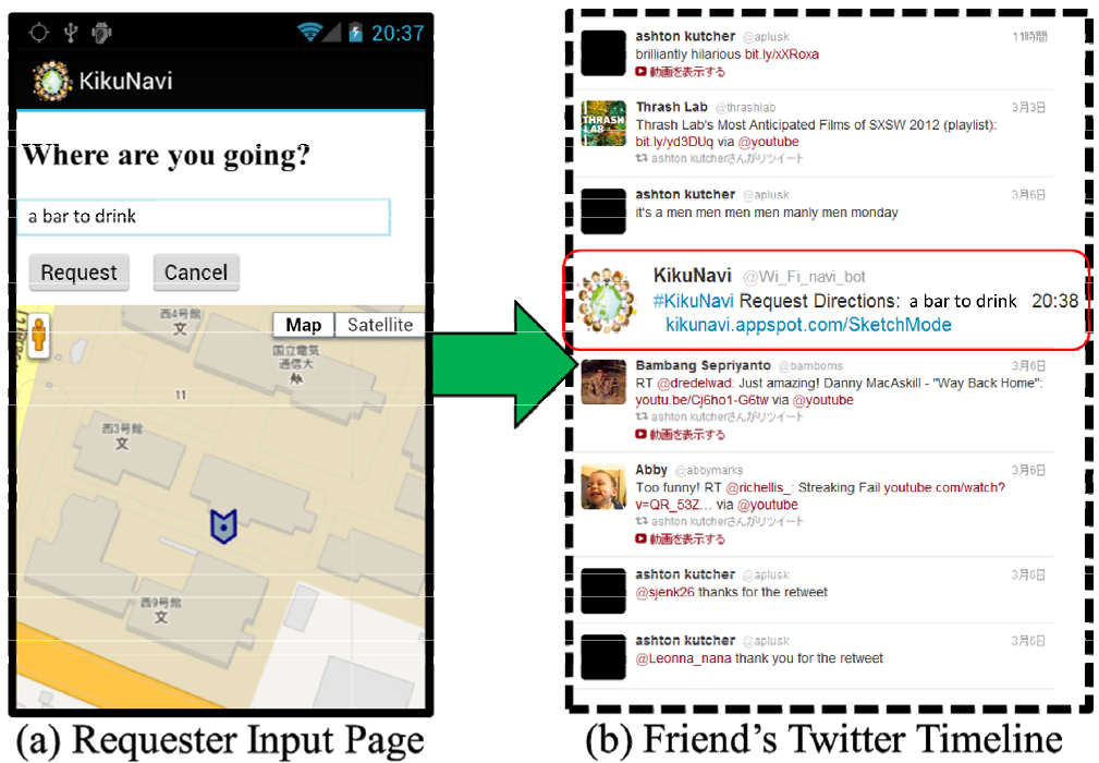 Figure 1: The Request-Response cycle via Twitter integration.
Real-World Evidence: The Campus Festival Test
The researchers tested KikuNavi during a university festival—a notoriously difficult environment for GPS due to temporary stalls and crowded pathways.
The results were compelling. Navigators were able to decode complex human needs. When a user asked for "a place our children will enjoy," the human navigator bypassed the nearby (but boring) academic buildings and led them straight to a game booth. In another instance, a navigator diverted a user away from a finished event to a still-active one—something a static map could never do.
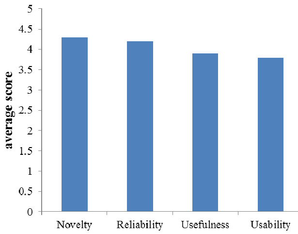 Figure 2: User satisfaction scores across novelty, reliability, usefulness, and usability.
Critical Analysis & Future Outlook
Strengths:
- Privacy by Design: The system allows guidance without requiring the user to reveal their identity or engage in awkward phone calls.
- Language Agnostic: The use of a simple direction arrow means a tourist could theoretically be guided by a local without either speaking the same language.
Limitations:
- Scaling Risks: The system relies on the altruism of Twitter users. Without a "gamified" reward system or a high volume of active users, a request might go unanswered.
- The "Map Overload": User feedback suggested that seeing both a Google Map and the KikuNavi arrow was confusing, suggesting a need for a more streamlined UI.
Conclusion
KikuNavi represents a shift from Man-Machine Navigation to Man-Man Navigation supported by Machines. As we move toward smarter cities, the integration of "Collective Intelligence" as a live layer over our digital maps may be the key to ensuring no one stays lost for long.
Takeaway for Developers: When the environment is too dynamic for an API, the best "sensor" is a human being with a smartphone.