
LINK2U: Bridging the Gap Between Digital Social Maps and Physical Reality
LINK2U: Connecting Social Network Users through Mobile Interfaces
LINK2U is a mobile social networking framework that integrates Augmented Reality (AR) with Location-Based Services (LBS). Developed for the Android platform, it allows users to switch between 2D Map and 3D Live modes to locate social contacts and navigate to points of interest (POIs).
TL;DR
LINK2U is an innovative mobile system that transforms social networking from static lists into a dynamic, orientation-aware experience. By combining Augmented Reality (AR) with 2D mapping and introducing smart "visual aggregation" techniques, it allows users to find friends and navigate complex environments (like university campuses) without the typical screen clutter of legacy LBS apps.
Background Positioning: More Than Just a Map
In the landscape of 2000s/early 2010s social tech, apps like Google Latitude provided basic "dots on a map" functionality. LINK2U positions itself as a successor that moves the interaction from the "bird's eye view" to the "user's eye view." It sits at the intersection of Human-Computer Interaction (HCI) and Ubiquitous Computing, focusing specifically on pedestrian navigation and social discovery.
The Problem: The "Clutter" and "Coverage" Dilemma
The authors identify two significant hurdles in mobile social networking:
- Sensorial Overload: When dozens of users are in an "Area of Social Network User Aggregation" (ASA), a small mobile screen becomes unreadable.
- GPS Limitations: Relying solely on GPS leads to failures indoors. LINK2U addresses this by integrating a WiFi Positioning System (WPS), triangulating signals from hotspots to ensure "everywhere" connectivity.
Methodology: The Multimodal Paradigm
The core of LINK2U is its Multimodal Interaction Paradigm. Guided by Don Norman’s theory of the "Execution-Evaluation Cycle," the system minimizes the cognitive distance between wanting to find someone and actually seeing them.
1. Dual-Mode Interface
- Map Mode (2D): Triggered when the device is laid flat. Best for global orientation and long-distance planning.
- Live Mode (3D/AR): Triggered when the device is raised. It overlays digital markers onto the real-world camera feed, allowing for intuitive target recognition.
2. High-Density Visualization (Grouping Methods)
To solve the clutter issue, the authors used two specific metaphors:
- Sector-Based Saturation: The world is divided into sectors. Instead of showing individual icons, the interface shows an arc where the color intensity (S) is calculated based on the ratio of active users in that sector: .
- ASA Icons: When user density exceeds a threshold, individual markers collapse into a single "Cluster Icon," revealing details only when zoomed in.
 Fig 1. Left: Sector division around the user. Right: The visual representation of user density using color saturation.
Experiments: Link2U@Unisa
The system was prototyped at the University of Salerno. Using a client-server architecture, the system synchronized user positions in real-time.
Key Technical Components:
- Android/OpenGL ES: For 3D rendering in Live mode.
- GPX Data Format: For lightweight route interchange.
- GeoNames Integration: To obtain elevation data (Z-axis) which GPS often misses, ensuring AR markers appear at the correct height in the camera view.
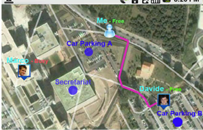 Fig 2. (a) 2D Map view for global context. (b) 3D Live mode for immediate visual identification of a contact.
Critical Insight & Future Outlook
The genius of LINK2U lies in its orientation-based switching. By simply tilting the phone, the user moves from "abstract planning" (Map) to "physical action" (AR). This solves the "Gulf of Evaluation"—the frustration users feel when they can't match a 2D icon to a person standing 20 meters away in a crowd.
Limitations: The current version relies on a "broadcast node" server, which may face scalability issues if user counts reach the millions. Furthermore, the WiFi triangulation requires a pre-cataloged database of Access Points, making it less effective in unmapped rural areas.
Conclusion: LINK2U serves as a foundational blueprint for how spatial computing will handle social data. It proves that the future of social networking isn't just about "who" you know, but "where" they are relative to your immediate field of vision.