
GEO REACH: Bridging the Gap Between Social Connectivity and Physical Space
Answering Location-Aware Graph Reachability Queries on GeoSocial Data
This paper introduces GEO REACH, a novel system for answering "RangeReach" queries on GeoSocial graphs, which determine if a vertex can reach any spatial entity within a specific geographic range. By augmenting graph nodes with spatial reachability metadata (SPA-Graph), the method achieves up to 100x speedup in query performance compared to traditional decoupled spatial-reachability indexing.
TL;DR
GEO REACH is a high-performance framework designed to solve the RangeReach problem: "Can person X reach any restaurant in San Diego through their social network?" By embedding spatial reachability metadata—such as bounding boxes and grid cells—directly into graph nodes, GEO REACH prunes search spaces early. It outperforms state-of-the-art decoupled indices by up to 100x in speed while using 75% less storage.
Problem & Motivation: The Decoupling Penalty
In modern GeoSocial graphs (like Facebook check-ins or Yelp reviews), data is bipartite: social links (who knows whom) and spatial attributes (where entities are). Existing systems usually solve location-aware queries by:
- Using a Spatial Index (e.g., R-Tree) to find all points in a target region .
- Using a Reachability Index (e.g., PLL or Feline) to check if the source can reach any of those points.
This "SpaReach" approach is fundamentally inefficient. It performs redundant reachability checks for thousands of points that might be geographically close but socially unreachable. The authors' insight is that geography should be treated as a first-class citizen within the graph topology, allowing the search to "fail fast" if a branch leads to a physical area outside the query range.
Methodology: The SPA-Graph
The core of the paper is the SPA-Graph (SPatially-Augmented Graph). Instead of a uniform index, it uses a hierarchical, adaptive approach to store reachability info on vertices based on their complexity:
- B-Vertex (Binary): The simplest form. It stores a single bit (
GeoB) indicating if any spatial vertex is reachable. If false, the traversal stops. - R-Vertex (Rectangle): Stores a Reachability Minimum Bounding Rectangle (RMBR). This box encloses the physical coordinates of all reachable spatial nodes. If the query range doesn't overlap with this box, the entire sub-graph is pruned.
- G-Vertex (Grid): The most precise. It stores a list of specific grid cells (ReachGrid) containing reachable nodes. This is used for complex reachability patterns where a single rectangle would be too vague (too much "dead space").
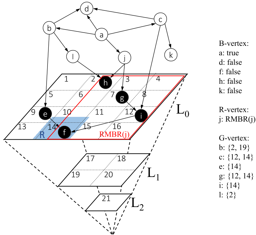 Fig 1: The SPA-Graph architecture showing how different nodes (B, R, G) manage spatial reachability info across grid layers.
Experiments & Results
The authors integrated GEO REACH into the Neo4j graph database and compared it against SpaReach-PLL and SpaReach-Feline.
Query Efficiency
As the spatial range grows, traditional methods struggle because the number of candidate points to check increases linearly. However, GEO REACH remains stable or improves because its pruning efficiency increases—larger rectangles are easier to match with internal RMBRs or Grids.
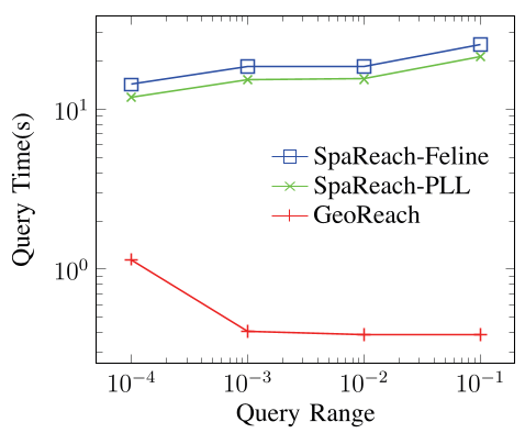 Fig 2: Query time comparison. GEO REACH maintains sub-millisecond performance even as selectivity increases.
Storage and Scalability
By using parameters like MAX_RMBR and MAX_REACH_GRIDS, the system can "degrade" complex grid indices into simpler rectangles or bits to save space. This flexibility allows GEO REACH to maintain a significantly smaller storage footprint (up to 4x smaller) than maintaining separate, heavy-duty spatial and reachability indices.
Critical Insight & Conclusion
The significance of GEO REACH lies in its data-aware pruning. Instead of checking reachability after spatial filtering, it combines them into a single traversal logic.
Limitations:
- The current model assumes a static graph. In real-world social networks where edges (friendships) and spatial attributes (check-ins) change by the second, the cost of re-calculating RMBRs and ReachGrids could be high.
- It is optimized for "True/False" reachability. Returning the actual paths or the nearest reachable node would require further algorithmic evolution.
Future Outlook: This work paves the way for "Spatial Influence Maximization"—identifying which social influencers can spread a message to a specific physical neighborhood most effectively.