
Watchtowers in the Network: Leveraging Social Data for Lightning-Fast Spatial Queries
Exploiting location-aware social networks for efficient spatial query processing
This paper introduces two parameter-tunable frameworks, Uniform Watchtower (UW) and Hot zone-based Watchtower (HW), for efficient kNN and range query processing on large-scale road networks. By utilizing check-in data from location-aware social networks, the HW framework optimizes POI search by deploying more "watchtowers" in geographic hot zones, outperforming state-of-the-art methods like ROAD and Islands.
TL;DR
Spatial query processing on large road networks often hits a wall when POIs (Points of Interest) are sparse. This paper introduces a Watchtower-based framework that uses distance signatures to "short-circuit" search algorithms. By analyzing social media check-ins via Gaussian Mixture Models, the system identifies "hot zones"—areas where people actually go—and optimizes index density accordingly, achieving a 6x speedup over existing SOTA methods like ROAD.
Background: The Scalability Trap
In the world of Location-Based Services (LBS), k-Nearest Neighbor (kNN) and range queries are the bread and butter. However, two common pitfalls plague current architectures:
- Blind Expansion: Dijkstra-based searches expand in all directions, wasting CPU cycles on empty road segments.
- Storage Bloat: Methods like "Islands" store distance data at every node, which is a nightmare for memory when dealing with continental-scale networks.
The authors ask: Can we use human behavior (social check-ins) to build a smarter, thinner index?
Methodology: The Architecture of Watchtowers
The core innovation lies in the transition from Uniform Watchtowers (UW) to Hot zone-based Watchtowers (HW).
1. The Watchtower Concept
Instead of storing data everywhere, the authors deploy "Anchor Points" at intersections and at intervals of distance . "Watchtowers" are then selected every anchor points. Each watchtower stores a tiny tuple: (POI_ID, Distance).
When you query the network, the Dijkstra search doesn't need to reach the POI; it only needs to hit a nearby watchtower to know exactly how far the POI is.
2. Hunting for Hot Zones (HW Framework)
Humans don't move randomly. Using check-in data from Gowalla, the authors employ Model-based Clustering (Mclust).
- GMM Clustering: Check-ins are modeled as a mixture of 2D Gaussian distributions.
- BIC Selection: The Bayesian Information Criterion automatically determines the optimal number of clusters (hot zones) without human tuning.
- Discriminatory Deployment: In hot zones (high-density clusters), watchtowers are placed close together (). In "cold" zones, they are sparse (), saving massive amounts of storage.
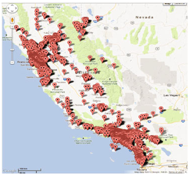 Figure: Visualizing social check-ins in California to identify geographic hot zones for index optimization.
Why It Works: The "H" Factor
The authors prove mathematically that if is the ratio of uniform vs. hot-zone watchtower spacing, the speedup for a query inside a hot zone is proportional to . By concentrating "knowledge" where it is most needed, the system achieves sub-millisecond latencies for most real-world queries.
Experimental Results: Slaying the Baseline
The team tested their frameworks against ROAD and Islands on three massive datasets: California (CA), North America (NA), and San Francisco (SF).
- Performance: On the NA network (~175k nodes), HW and UW outperformed ROAD significantly. As (number of neighbors) increased, the gap widened: at , our watchtower approaches were 6x faster.
- Index Size: While the Islands approach ballooned to 3.5 GB for 10,000 POIs, the HW framework occupied only 35.3 MB—a 100x reduction in memory footprint.
- Maintenance: By using a Shortest Path Tree (SPT) update mechanism, the system can handle adding/removing edges or POIs with minimal page accesses, making it viable for dynamic environments.
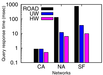 Figure: Comparison of index size and query response time across different road networks.
Critical Insight & Future Work
The beauty of this work is its parameter-tunability. It acknowledges that we don't need perfect information everywhere. By using the Distance Bound (), the authors optimize the tradeoff between pre-computation and query speed. They discovered that setting miles provides the "Goldilocks" zone for kNN queries in North America.
Limitations: The current model assumes POIs are distributed uniformly. In reality, POIs and query hot zones often overlap (e.g., more restaurants in a city center). Future iterations could benefit from a joint probability model of both POIs and users.
Takeaway
This paper is a masterclass in behavioral-aware systems design. It proves that "where people are" is just as important as "where the roads are" when building high-performance spatial databases.