
Empowering Crisis Management: The Strategic Role of Location-Based Crowdsourcing
Location-based Crowdsourcing in Disaster Response
The paper investigates "Location-based Crowdsourcing in Disaster Response," focusing on how emergency managers can leverage mobile technologies and volunteer participation to improve flexibility and coordination. It proposes a framework based on "Sense-Aware-Adapt" cycles to transform heterogeneous citizen data into actionable insights for crisis management.
TL;DR
In the chaos of a disaster, professional rescue services are often the bottleneck. This paper explores how Location-Based Crowdsourcing leverages the "Social Crowd" to act as distributed sensors, providing emergency managers with real-time, geocoded data that enhances flexibility and improvisational capacity when standard protocols fail.
The Bottleneck of Authority
During catastrophic events like the Ebola outbreak or massive earthquakes, the quality of response often declines despite technological advancements. The paper identifies a core friction: The Conflict of Logic. Traditional disaster response relies on a top-down, authoritative control of information. However, disasters are inherently decentralized and unpredictable. When professional resources hit a "bottle-neck," the inability to coordinate willing but unorganized volunteers can actually exacerbate the crisis (e.g., volunteers clogging roads during floods).
The Framework: Sense, Be Aware, Adapt
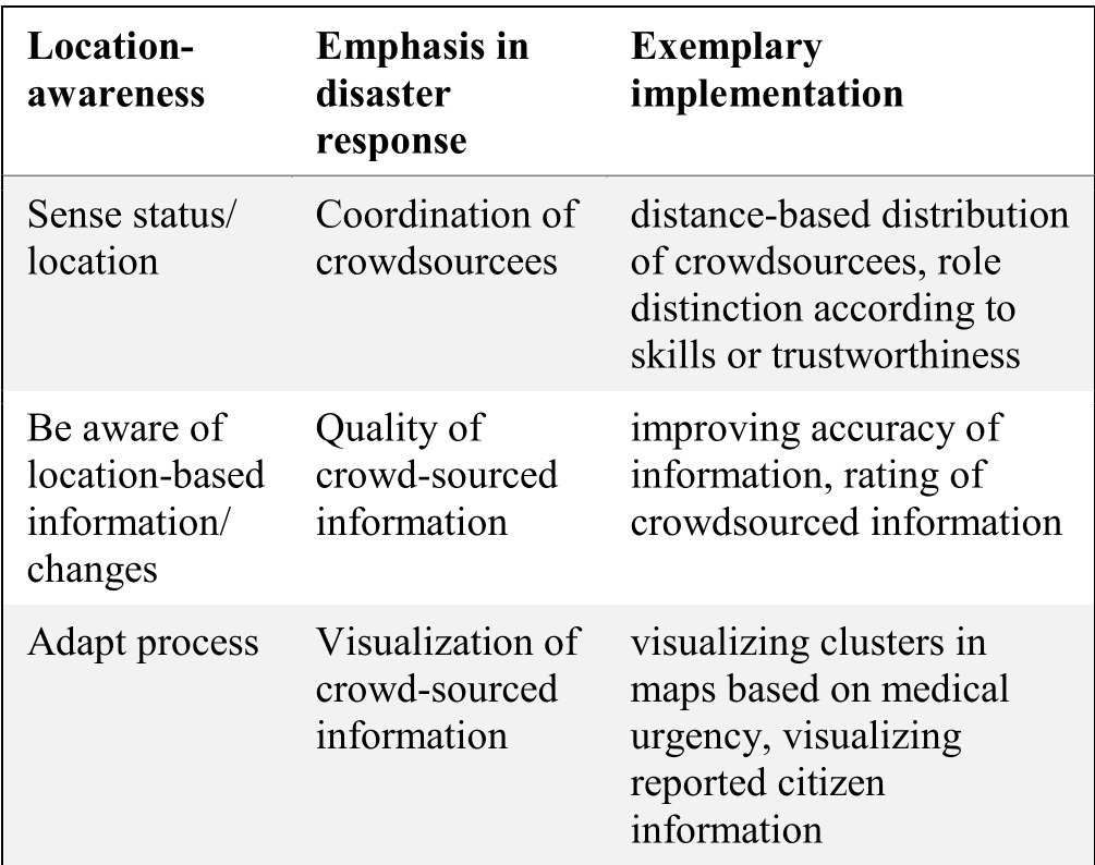
The authors derive a three-step cycle to integrate location-awareness into the business processes of disaster relief:
- Sense (Coordination): Moving beyond just "collecting data," this phase involves identifying where crowdsourcees are and what skills they possess. By using Geocoding, managers can implement distance-based or population-based distribution, ensuring that every municipality has a "sensor" without over-allocating resources.
- Be Aware (Data Quality): Crowdsourced data is notoriously noisy. The paper highlights mechanisms like "trusted sensors" (vetted volunteers) and standardized reporting tools (e.g., using a physical "water level ruler" with color-coded bands to help citizens report flood levels accurately).
- Adapt (Decision Support): The final stage is turning raw data into visual evidence. By clustering victims based on Medical Urgency or proximity to hazards, managers can shift the strategy from "best outcome for one" to "best outcome for the greatest number."
The Spectrum of the Crowd
A key insight provided is the Heterogeneity of the Crowd. Not all volunteers are equal. The paper suggests a tiered role system:
- Citizen: Basic reporting.
- Sensor: Sends data in response to warnings.
- Trusted Sensor: Registered volunteers with minimal training (e.g., Team Österreich).
- Node/Agent: Trained individuals who can lead evacuations or perform medical triage under remote supervision.
Critical Analysis & Future Outlook
The paper successfully argues that crowdsourcing isn't just about "free labor"—it's about Spatial Intelligence. However, it also honestly addresses the "Digital Divide." If response is driven by smartphone data, the elderly or those in low-income areas risk becoming invisible on interactive disaster maps.
Takeaway for the Industry: Future disaster response systems must not only be "mobile-first" but also "incentive-compatible." As we move into an era of AI, the ability to automatically verify the reliability of a "trusted sensor" via historical data and spatial consistency will be the next frontier in location-based crowdsourcing.
Key Performance Comparison from Modern Systems
Note: The paper highlights the "Did You Feel It?" system's ability to handle high-throughput (78 reports/sec) as a benchmark for successful large-scale citizen integration.
Source Reference: Ernst, C., Mladenow, A., & Strauss, C. (2016). Location-based Crowdsourcing in Disaster Response. ACM MoMM '16.