
Empowering Mobility: An Inclusive Location-Based SNS for the Physically Disabled
Design and Implementation of Location-Based SNS Smartphone Application for the Disabled Population
This paper presents a Location-Based Social Networking Service (LBSNS) specifically designed for the physically disabled. The system integrates real-time GPS tracking, a point-based validation system for accessibility info, and specialized accessibility features like TTS and Voice Recognition.
TL;DR
In a world where digital maps are ubiquitous, the physically disabled often remain underserved. This paper introduces a specialized Location-Based Social Networking Service (LBSNS) that bridges the information gap between the general population and disabled users. By combining real-time GPS data, community-verified markers, and accessibility tools like TTS (Text-to-Speech), the system creates a living map of accessible urban spaces.
The "Accessibility Gap" in Modern LBSNS
Mainstream social platforms like Facebook or Foursquare focus on "check-ins" and "social hype." However, for a user in a wheelchair, the most critical "social" information isn't who is at a bar, but whether that bar—and the route to it—is accessible.
The authors identify several critical pain points in existing solutions:
- Data Staticity: Information about disabled facilities is often outdated or buried in government PDF files.
- Lack of Trust: There is no mechanism to verify if a "disabled-friendly" label is actually accurate in practice.
- Complex UI: Standard interfaces can be overwhelming or physically difficult to navigate for those with motor impairments.
Methodology: A Community-Driven Verification Loop
The core innovation lies not just in the software stack, but in the Social-Validation Loop. The system utilizes a standard LAMP-like architecture (Linux, Apache, MySQL, PHP) to facilitate data flow to Android terminals, but it adds a layer of community consensus.
1. The Consensus Evaluation System
Users can register "markers" on a map. These aren't just pins; they are interactive reports containing photos and messages. To ensure reliability, the system implements a rating scale (1.0 to 5.0). This transforms the app from a simple directory into a trusted social network where "Reliability Points" define the value of information.
2. Specialized Accessibility Features
- RSS Integration: Pulls real-time data from the Seoul metropolitan government regarding public toilet locations.
- Proximity Awareness: To prevent information overload, the "Navigating in an Area" function limits marker visibility to a 500m radius.
- Multimodal Interaction: Integration of TTS and Voice Recognition allows users to interact with the map without high-precision touch requirements.
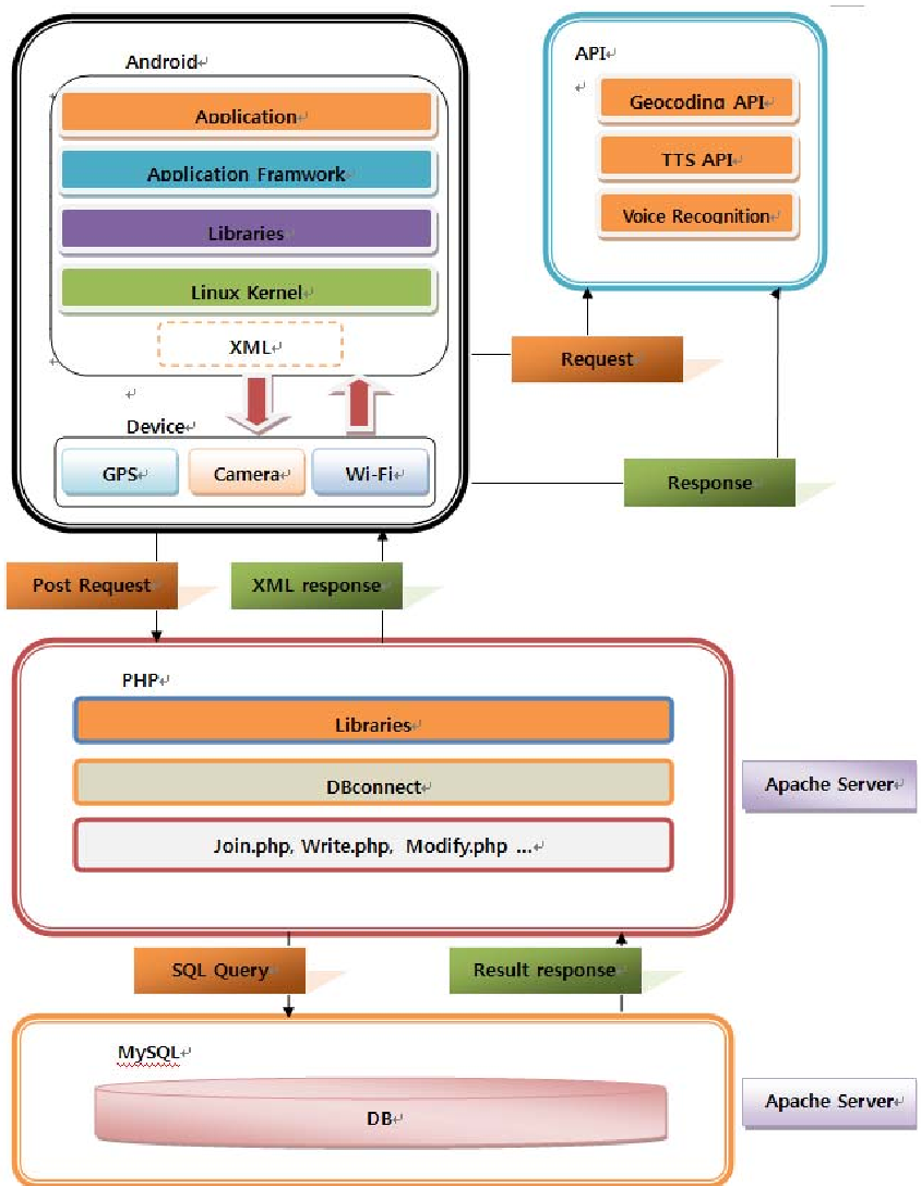 Figure 1: The multi-tier abstract structure ensuring real-time data synchronization.
Implementation and Human-Centric Design
The implementation emphasizes a low-friction user experience. For example, the Automatic Login feature was specifically highlighted to reduce the "typing effort" for users with fine motor challenges.
The data flow follows a strict sequence:
- Android terminal sends a POST request to PHP.
- PHP queries the MySQL database (including handling photo links via string paths to reduce overhead).
- Data is returned as an XML package for the Android terminal to parse and display.
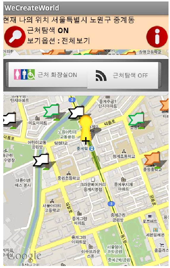 Figure 2: Selected UI menus showing the TTS interface and public toilet markers.
Critical Insight & Future Outlook
The true value of this work is the Democratization of Urban Data. By allowing the general population to register markers for the disabled, the paper fosters a collaborative environment.
Limitations: While the system is robust, its reliance on a 2011-era Android framework (2.1) means it lacks the modern AI-driven "Computer Vision" that could automatically identify obstacles (like broken sidewalks) from photos.
Future Directions: The next logical step for this research is the integration of Indoor Positioning Systems (IPS) and AI for Automatic Curb-Cut Detection, further reducing the manual labor required by the community to keep the map updated.
Conclusion
This paper serves as a blueprint for inclusive design in the mobile age. It reminds us that "Social Networking" isn't just about sharing photos—it's about sharing the vital information that makes the physical world accessible to everyone.