
Graph-Aware Privacy: Why Your Car's Location Needs Better Protection than a 2D Dot
Location Privacy Protection in Vehicle-Based Spatial Crowdsourcing via Geo-Indistinguishability
The paper proposes a novel location obfuscation framework for Vehicle-based Spatial Crowdsourcing (VSC). It introduces a road-network-aware version of Geo-Indistinguishability (Geo-I) and formulates the Vehicle based spatial Crowdsourcing Location Privacy (VLP) problem to minimize Quality-of-Service (QoS) loss while maintaining formal privacy guarantees.
TL;DR
Standard location privacy masks your position by treating the world like a flat paper map. But for vehicles, the world is a complex graph of one-way streets and dead ends. This paper introduces a Graph-Based Geo-Indistinguishability framework that protects vehicle privacy while ensuring the "Quality of Service" (how accurately a server can assign tasks) remains high by respecting the actual physical constraints of road networks.
The Problem: The "Euclidean Illusion" in Vehicular Networks
Most location-based services (LBS) use Geo-Indistinguishability (Geo-I), a statistical privacy standard ensuring that if you are at location A, the noisy location you report could just as likely have come from a nearby location B. Traditionally, "nearby" is measured by Euclidean distance (as the crow flies).
However, for a vehicle, Euclidean distance is a lie. Two points might be 100 meters apart across a river but require a 5-kilometer drive to reach.
- Prior Work Failure: If a privacy algorithm suggests an obfuscated location across a river, the service provider (like Uber or a delivery hub) will face massive "QoS loss" because the estimated travel time becomes wildly inaccurate.
- The Insight: Privacy in VSC must be measured by Shortest Path Distance (ShPD) on a directed weighted graph, not circles on a plane.
Methodology: From Continuous Chaos to Linear Programming
The authors transform the difficult problem of finding an optimal "probability distribution" of reported locations into a solvable math problem through three steps:
1. Discretization (D-VLP)
The road network is chopped into small intervals of length . Instead of calculating privacy for every infinite point on a road, we calculate it for these discrete "buckets."
2. The D-VLP Linear Program
The goal is to minimize the expected estimation error of the shortest path: Where is the probability of reporting interval when the driver is actually in interval .
3. Solving the Complexity Bottleneck (Transitivity)
A naive implementation of Geo-I creates constraints (where is the number of road segments). For a city like Rome, this is computationally impossible. The authors prove that because shortest paths in a graph satisfy the Triangle Inequality, you only need to enforce privacy constraints between adjacent road segments.
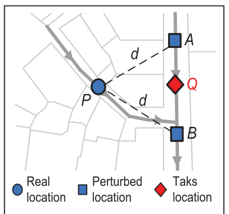 Figure 1: By partitioning roads into intervals and building an auxiliary graph, the system maps physical constraints into a solvable mathematical structure.
Real-World Battle Test: Rome Taxi Data
The authors tested their algorithm using real GPS traces from 120 taxis in Rome.
Better Privacy, Better Service
Compared to the 2D-based state-of-the-art (2Db), the graph-aware method achieved:
- 12.35% Lower QoS Loss: Task assignments were more accurate because the noise was "road-aware."
- 6.91% Higher Adversary Error: Even though service was better, the attacker was further away from guessing the true location.
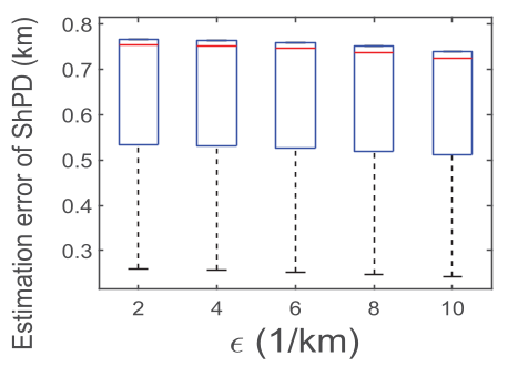 Figure 2: Performance metrics show that the proposed method (in blue) consistently provides lower estimation errors and higher protection than 2D approaches across different privacy budgets ().
Speeding Up the Math
The Constraint Reduction (CR) method was the MVP of the experiments. It reduced the computation time by 87.9%, making it feasible to run these complex optimizations on standard hardware.
Critical Insight & Future Outlook
This work highlights a growing trend in AI/Privacy: Context-Awareness. Generic privacy algorithms often destroy the utility of the data because they don't understand the underlying physics or logic of the domain (in this case, road topology).
Limitations: While the constraint reduction is impressive, the system still relies on a centralized solver. For a global system like Uber, a decentralized version—where each vehicle calculates its own obfuscation distribution—would be the next logical step to ensure even the central server doesn't hold the keys to the kingdom.
Conclusion
By moving from the "flat earth" Euclidean model to a graph-based reality, this paper provides a roadmap for protecting our mobility data without breaking the apps we rely on every day.