
CYGNSS & ANN: Breaking Through Monsoon Saturation for Precision Soil Moisture Retrieval
Machine Learning Based Soil Moisture Retrieval Algorithm and Validation at Selected Agricultural Sites Over India Using Cygnss Data
This paper presents a machine learning-based framework utilizing Artificial Neural Networks (ANN) to retrieve Soil Moisture (SM) from CYGNSS GNSS-Reflectometry data over India. By integrating CYGNSS surface reflectivity with SMAP-derived vegetation and roughness parameters, the model achieves high-frequency spatio-temporal SM estimation, validated against both SMAP products and in-situ hydra probe sensors.
TL;DR
This research introduces a localized Artificial Neural Network (ANN) framework for India that transforms satellite-based GNSS-Reflectometry (CYGNSS) into high-resolution soil moisture (SM) data. By fusing radar reflectivity with vegetation and roughness metrics, the model achieves an RMSD of 0.057 m3/m3 and, crucially, avoids the "saturation effect" that plagues mainstream sensors like SMAP during the heavy Indian monsoon.
The Problem: The "Blind Spots" of Traditional Sensing
Soil moisture is the heartbeat of agricultural planning. However, we face a technical paradox:
- Passive Microwave (SMAP/SMOS): Reliable but has coarse spatial resolution and often "maxes out" (saturates) when the soil is very wet.
- Optical Sensors: High resolution but useless when there is cloud cover—a permanent fixture during monsoon seasons.
- The India Factor: Complex topography and small-scale field variability make global linear models highly inaccurate.
The authors identify that while CYGNSS (8 micro-satellites) offers incredible temporal frequency, its data isn't a direct measure of moisture—it’s a raw signal that needs a sophisticated "translator."
Methodology: The ANN "Translator"
The study moves away from simplistic linear regressions. Instead, it utilizes a non-parametric Artificial Neural Network (ANN) to learn the physics of the land surface.
The Input Vector
The model doesn't just look at how "shiny" the soil is to radar; it considers three critical dimensions:
- Surface Reflectivity (): Derived from the Delay Doppler Map (DDM) using the coherent scattering range equation.
- Vegetation Water Content (VWC): To account for signal attenuation through the crop canopy.
- Surface Roughness: Collected from SMAP to correct for diffuse scattering.
Mathematical Intuition
The authors corrected the raw reflectivity for the Local Incidence Angle (LIA): By setting , they balanced the correction to prevent overcompensating for rough surfaces, ensuring the neural network receives a clean signal focused primarily on dielectric changes (moisture).
Experiments & Results: Outperforming the Gold Standard
The validation was conducted across agricultural sites in Anand (Gujarat) and Kharagpur (West Bengal).
1. The Monsoon Breakthrough
Perhaps the most significant finding is shown in the temporal analysis. During the monsoon peak (July to October), the official SMAP product often shows a "flat line"—it is saturated.
- The CYGNSS Edge: CYGNSS SM continued to track in-situ Hydra probe data accurately, capturing the dynamic fluctuations of heavy rain and subsequent drying that SMAP missed.
2. Quantitative Accuracy
The model demonstrated impressive consistency across seasons:
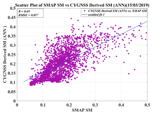
- Pre-Monsoon: R = 0.69, RMSD = 0.057 m3/m3.
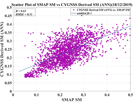
- Post-Monsoon: R = 0.65, RMSD = 0.053 m3/m3.
Critical Insight & Future Outlook
This work demonstrates that for regional agricultural monitoring, data fusion is king. By using coarse-resolution parameters (VWC/Roughness) to constrain a high-temporal frequency signal (CYGNSS), we get the best of both worlds.
Limitations: There remains a slight "scale bias" because the model compares 36km SMAP pixels with quasi-point CYGNSS specular points. The authors suggest that implementing Cumulative Density Function (CDF) matching in the future could further sharpen the results by removing these systemic biases.
Takeaway: For researchers in South Asia and similar tropical climates, this ANN-based GNSS-R approach offers a robust path forward for irrigation mapping and flood forecasting even under the thickest cloud cover.