
MapIT: Empowering Grassroots Development Through Precision Micro-mapping
Micro-mapping with smartphones for monitoring agricultural development
The paper introduces MapIT, a smartphone-based micro-mapping system designed to capture the precise geometry of small agricultural entities (e.g., fish ponds, rice fields) for development monitoring. By combining image processing with inertial sensors, the system enables laypeople to generate Volunteered Geographic Information (VGI) with high spatial accuracy.
TL;DR
Development projects in rural areas, such as the fish pond initiatives in Lao PDR, often fail to scale because their impact is hard to measure accurately. MapIT solves this by turning standard smartphones into precision surveying tools. By simply taking a photo and tracing an outline, local stakeholders can map small geographic features with less than 5% error, bridging the gap between local action and administrative data.
The "Reporting Gap" in Development
The primary bottleneck in monitoring agricultural development isn't a lack of progress—it's a lack of verifiable data. In regions like Lao PDR, small-scale projects (e.g., backyard fish ponds for protein supply) are highly effective but geographically fragmented.
Existing solutions fall short:
- Commercial GPS: Inaccurate for small boundaries; can't capture shape/area effectively.
- Satellite Imagery: Often expensive, obstructed by cloud cover, or lacking the resolution to distinguish a small pond from its surroundings.
- Expert Surveying: Too costly and slow for continuous grassroots monitoring.
Methodology: High-Accuracy Geometry from a Single Photo
The core innovation of the MapIT system is the Inverse Perspective Transformation. Instead of relying solely on GPS coordinates, the system treats the smartphone as a sophisticated optical sensor.
The Workflow
- Capture: The user takes a photo of the object (e.g., a rice field).
- Interaction: The user traces the outline on the touchscreen.
- Transformation: The system reads the device's inertial sensors (accelerometer/gyroscope) to determine the camera's tilt and height.
- Projection: Using the Douglas-Peucker algorithm to simplify the trace, the pixels are projected onto the ground plane to calculate the exact real-world dimensions.
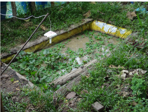 Figure 1: Potential objects of interest such as small rice fields and backyard fish ponds that require precise boundary mapping.
Experimental Validation
To test the system's reliability, the researchers mapped standardized objects—parking lots—comparing the MapIT results against ground-truth measurements.
- Area Accuracy: Achieved a 3.4% average deviation.
- Geometric Precision: Length errors remained under 5%, even when the user was standing 15 meters away from the target.
This level of accuracy is critical. For a farmer, a 5% difference in area calculation is the difference between a successful yield estimate and a failed logistics plan.
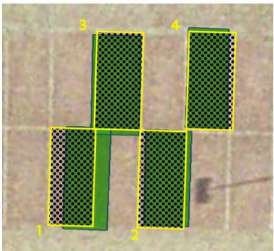 Figure 2: Evaluation showing the mapped objects (green) against original boundaries (black dotted), demonstrating the system's high geometric fidelity.
Critical Insight: The Shift to "Small Data"
While the tech industry is obsessed with "Big Data," the MapIT project highlights the power of "Precision Thick Data." By enabling local, often illiterate stakeholders to provide high-quality spatial data via speech recognition and intuitive drawing, the system fosters a sense of ownership over the development process.
Limitations and Future Outlook
While the system is robust, its current accuracy depends on the user correctly identifying the height of the device above the ground and having a clear line of sight. Future iterations could leverage Augmented Reality (AR) frameworks to provide real-time feedback on the trace accuracy, further reducing the margin of error.
Conclusion
MapIT represents a significant step in ICT4D (Information and Communication Technology for Development). It proves that sophisticated geometric algorithms, when wrapped in a "barrier-free" interface, can empower local communities to become active participants in the global data ecosystem.