
LARS: Mapping the World’s Best Vista Points via Crowdsourced Photo Mining
Mining Crowdsourcing Photos for Recognizing Landmark Areas
The paper introduces the Landmark Area Recognition System (LARS), which automatically delineates landmark regions by mining crowdsourced photo metadata from Flickr and Google Maps. It proposes DBCGM (Density-Based Clustering with Greedy Method) to identify high-quality vista points and uses the Concave Hull algorithm to visualize these areas on digital maps.
TL;DR
LARS (Landmark Area Recognition System) is a spatial mining framework that identifies the boundaries of famous landmarks not by their physical coordinates, but by where people actually take the best photos. By introducing a new density-based clustering method called DBCGM, the system can process massive Flickr datasets to automatically draw "scenic areas" on Google Maps with higher efficiency and accuracy than standard algorithms like DBSCAN.
The Motivation: Landmarks Are More Than Just Coordinates
In traditional navigation, a landmark like the "Eiffel Tower" is a single GPS pin. However, for a photographer or a tourist, the experience of the tower spans several blocks and riverbanks. Existing methods for finding these "vista points" often rely on manual curation or computationally heavy spatial clustering.
The authors identified two major gaps:
- Data Quality: Platforms like Facebook are filled with "noise" (food photos, selfies in shops). Flickr, however, attracts photographers sharing high-quality, high-relevance scenic views.
- Computational Bottlenecks: Standard clustering algorithms like DBSCAN scan individual points, which is unworkable when dealing with the "Big Data" of global social media metadata.
Methodology: Shifting from Points to Blocks
The core innovation of LARS lies in its hierarchical approach to spatial data. Instead of treating every photo as an independent unit, the system uses a Location-Based Search Engine (LBSE) to partition the world into a grid of 64.8 billion blocks.
The DBCGM Algorithm (Density-Based Clustering with Greedy Method)
Unlike traditional DBSCAN which expands by searching for neighbors of every point within a radius (), DBCGM operates at the block level:
- It selects the block with the highest density of photos.
- It uses a Greedy Method to expand to the densest neighbor within a "9-square" or "25-square" grid.
- This "block-hopping" continues until density drops below a threshold ().
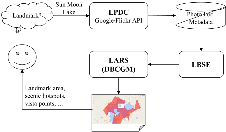 Figure: The system workflow from metadata extraction to landmark area visualization.
By processing blocks rather than points, the algorithm avoids redundant distance calculations, drastically reducing execution time while maintaining (or even improving) clustering quality.
Experimental Results: Faster and More Accurate
The researchers tested LARS on 22 famous landmarks, including the Sun Moon Lake, Big Ben, and the Brooklyn Bridge.
- Accuracy: DBCGM achieved a peak F1-score of 0.735, outperforming optimized DBSCAN.
- Efficiency: The block-based greedy approach was over 2x faster than point-based searching.
- Visualization: By applying the Concave Hull algorithm rather than a standard Convex Hull, LARS generates tight, realistic boundaries that trace the actual paths and viewpoints used by tourists.
 Figure: Comparison between DBSCAN and DBCGM across various global landmarks.
Real-World Application: Intelligent Travel Planning
The output of LARS isn't just a research metric; it's a functional map. By clustering these photos, the system can automatically suggest travel itineraries. For example, at Sun Moon Lake, the system identified two distinct "scenic corridors"—one for boat-based sightseeing and another for mountain-view cable cars—based entirely on where users historically captured the most "representative" photos.
 Figure: LARS-generated landmark area for Sun Moon Lake, Taiwan, showing popular photographic clusters.
Critical Analysis & Future Outlook
While LARS is highly efficient, its reliance on manual verification (crowdsourcing 10% of photos to label them as "representative") remains a bottleneck for true global scaling.
The Next Frontier: The logical evolution for this work is the integration of Computer Vision (CV). Replacing manual verification with an AI-driven "Aesthetic Score" or "Landmark Classifier" would allow LARS to map every landmark on Earth in real-time, creating a dynamic, living world map for photographers and travelers alike.
Takeaway for Researchers: LARS proves that in the era of Big Data, "approximating" spatial data via grid-based indexing is often superior to "exact" point-based processing, both in speed and in capturing human-centric regional patterns.