
Smart Infrastructure: Bridging the Physical-Digital Gap via Mobile Crowdsourcing
A Mobile Crowdsourcing Platform for Urban Infrastructure Maintenance
The paper introduces a mobile crowdsourcing platform designed for urban infrastructure maintenance, leveraging NFC technology and social media integration. By combining "Tidepools" and "CartoDB" technologies, the system allows citizens to report infrastructure issues and track "Urban SmartObjects" in real-time.
TL;DR
This research presents a novel Mobile Data Hub platform that empowers citizens to act as urban inspectors. By integrating NFC (Near Field Communication) tags on physical city assets—termed "Urban SmartObjects"—and aggregating social media feeds, the platform creates a real-time, participatory map for urban maintenance and community engagement.
Background & Positioning
In the landscape of Smart City evolution, we are moving away from top-down sensor deployments to a Human-as-a-Sensor model. This paper sits at the intersection of Geocentric Crowdsourcing and the Internet of Things (IoT), aiming to solve the "last mile" problem of urban maintenance: how to efficiently report a broken streetlight or a damaged park bench with zero ambiguity.
The Core Friction: Why Current Reporting Fails
Most city management systems rely on manual patrols or vague phone reports. Even modern web portals suffer from:
- Geolocation Ambiguity: Citizens often struggle to describe the exact location of a specific asset in a sprawling park.
- Disconnected Context: Reports are often siloed, ignoring the wider social conversation (e.g., Twitter) regarding neighborhood safety or recurring issues.
- Low Friction Barrier: If a report takes more than 30 seconds, citizens likely won't do it.
Methodology: The Mobile Data Hub Architecture
The authors utilize a tiered architecture to bridge the gap between a physical "tap" and a digital database.
1. The Power of Proximity (NFC)
Unlike QR codes, which require camera focus and lighting, NFC allows for "Touch and Run" interaction. Each Urban SmartObject is equipped with an NFC tag. Tapping it triggers a URL that contains a specific ID, instantly pulling the asset's history and repair form from a CartoDB backend.
2. The Integrated Technology Stack
The system is built on an open-source foundation to ensure interoperability:
- Web Layer: Built with AngularJS and LeafletJS for high-performance mobile mapping.
- Service Layer: NodeJS handles asynchronous data streams from both users and the Twitter Search API.
- Storage: A hybrid approach using MongoDB (for fluid social data and events) and CartoDB (for structured geospatial assets).
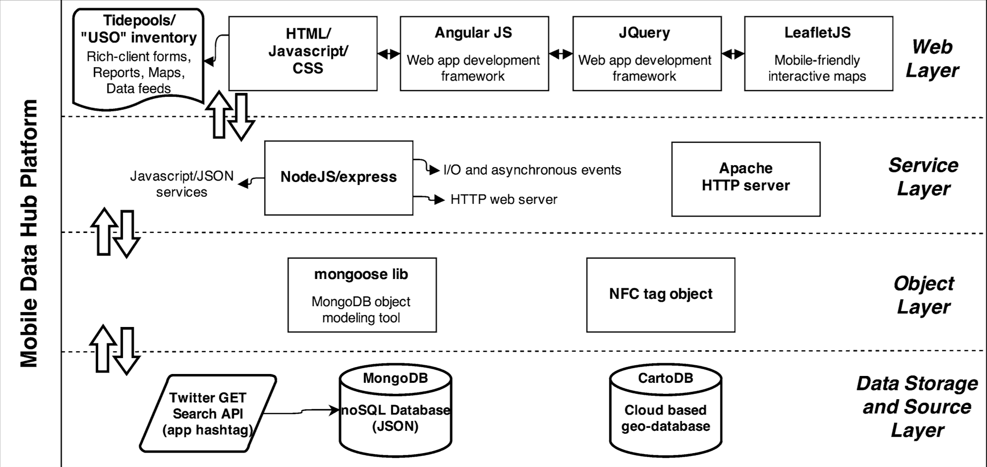 Figure 1: The multi-layered architecture facilitating data flow from physical tags to cloud storage.
Data Flow: From "Tap" to "Action"
The platform categorizes data into three distinct streams, all visualized on a unified map:
- SmartObject Layer: Specific to inventoried items (NFC-enabled).
- GeoReports Layer: For general "pothole" style reports without pre-existing tags.
- Community Events: A social layer for workshops or "mapping parties."
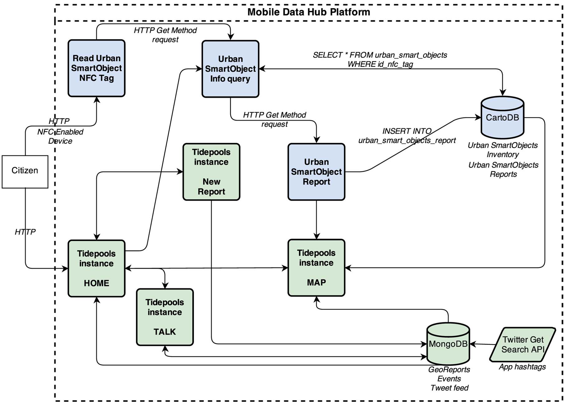 Figure 2: The logic diagram showing the query process for NFC-tagged assets.
Experimental Validation
The prototype demonstration showed that by using the Tidepools instance, the platform successfully aggregated disparate data types—Twitter feeds, SQL-based asset databases, and NoSQL user reports—into a single coherent UI. This proves that "hyperlocal" information can be crowdsourced effectively if the entry point (the UI and the NFC trigger) is simplified.
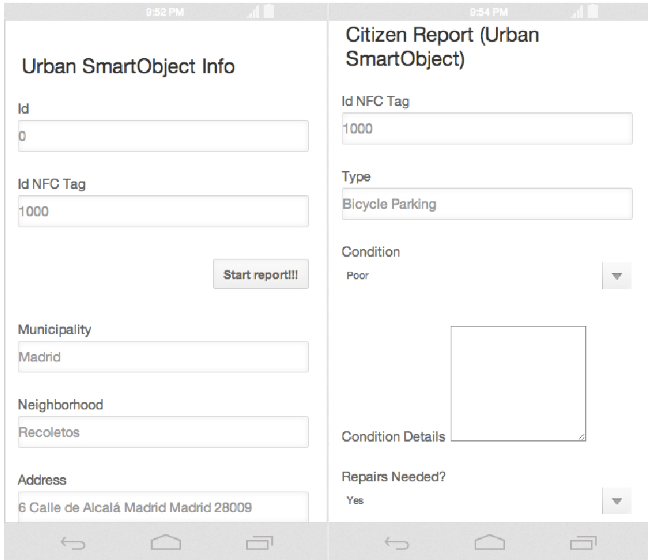 Figure 3: Mobile forms used by citizens to report the status of urban infrastructure.
Critical Insight & Future Outlook
While the platform is technically sound, its success hinges on citizen adoption. The authors rightly point out that moving forward, the focus must shift to data mining and clustering.
The real value of such a platform isn't just seeing a single broken bench on a map; it's using historical data analysis to predict which neighborhoods need budget increases or identifying "hotspots" of urban decay by analyzing the sentiment of tagged tweets. This work lays the essential groundwork for an automated, citizen-driven Geographic Information System (GIS).
Conclusion
This paper successfully demonstrates that the "Smart City" doesn't just belong to expensive industrial sensors. By leveraging the sensors already in our pockets and simple NFC tags on the street, we can transform infrastructure maintenance into a collaborative, transparent social event.