
MEPSGWS: Orchestrating Environmental Intelligence via Semantic Web Services
Modeling Environmental Process Using Semantic Geospatial Web Service
The paper introduces MEPSGWS (Modeling Environmental Process using Semantic Geospatial Web Service), a framework designed to integrate complex environmental models using Semantic Web technologies. It specifically leverages OWL-S and GML to facilitate interoperability and real-time online updates for composite watershed processes originally modeled via System Dynamics (STELLA).
TL;DR
Environmental modeling is evolving from isolated desktop simulations to distributed, interoperable web ecosystems. This paper presents MEPSGWS, a framework that utilizes Semantic Web Services (OWL-S) and GML to wrap traditional System Dynamics models (like those from STELLA) into modular, real-time-updatable web services. By decoupling the "cause-effect" logic from the underlying computation, it allows for a flexible, multi-disciplinary approach to complex watershed modeling.
The Bottleneck: Tightly Coupled Silos
In the realm of environmental science, problems like watershed management are "composite processes"—they involve physical, ecological, and social sub-models. Historically, tools like STELLA have been the gold standard for modeling these cause-effect chains.
However, STELLA models are often:
- Monolithic: Hard to break into reusable pieces across different organizations.
- Static: Difficult to update in real-time when new field data or better sub-models arrive.
- Proprietary: Lacking standardized interfaces for web-based interoperability.
The authors argue that the "Next-Gen" of GIS integration must shift from simply linking data to modeling semantic processes.
Methodology: The MEPSGWS Architecture
The core innovation lies in treating an environmental process as a Semantic Web Service. The architecture is bifurcated into two conceptual layers:
1. The Knowledge Layer (Semantic Logic)
Using OWL-S (Web Ontology Language for Services), the authors define the behavior of the environmental models.
- Atomic Processes: Individual models (e.g., a specific Rain Model).
- Composite Processes: The workflow that chains these models together.
- Semantic Rules: Representing cause-effect linkages using "If-Then-Else" constructs. For instance, a "Precipitation" model only triggers if the "Rain" model output is valid.
2. The Data & Transport Layer (Technical Interoperability)
- GML (Geography Markup Language): Used for input/output parameters. This ensures that when a model outputs a "multipolygon" of soil erosion, another model understands exactly what that data structure represents.
- SOAP/WSDL: The technical "plumbing" that enables remote procedure calls over the internet.
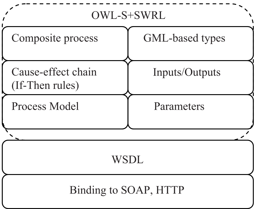 Figure 1: The dual-layer architecture of the Semantic Geospatial Web Service.
Case Study: Rain and Soil Loss
To validate the framework, the authors transitioned a STELLA-based watershed model into the MEPSGWS environment.
In the old world (STELLA), the rain intensity, runoff, and soil erosion were hard-coded icons in a single file. In the MEPSGWS world:
- The Rain Model is a Java-based service hosted on a remote server.
- The Soil Loss Model consumes the output of the Rain Model via a standardized GML stream.
- Scientists can update the "Rain Model" on the server (e.g., swapping a simple linear model for a dynamic forecasting model) without breaking the overall watershed simulation.
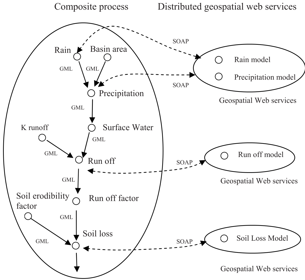 Figure 2: Transforming STELLA logic into an OWL-S composite process sequence.
Experimental Insight: Real-Time Updates
The authors specifically highlight the "RainModel" deployment on an Apache SOAP server. The pivotal advantage is flexibility. By referencing the service via a URI, the composite process remains agnostic to the model's internal implementation. This solves the "interoperability" pain point where different departments (e.g., Hydrology vs. Geology) use different software stacks but need to share a unified impact pathway.
Critical Analysis & Future Outlook
Takeaway: This work represents an early but vital step toward a Semantic Geospatial Web. By moving beyond simple data sharing to shared process logic, it allows for more robust environmental impact statements (EIS).
Current Limitations:
- The use of SOAP (the protocol of choice in the mid-2000s) has largely been superseded by REST and JSON-FG in modern GIS.
- The complexity of writing OWL-S XML is high, suggesting a need for more intuitive graphical composers for researchers.
Future Directions: The authors envision a middleware-driven simulation environment. In the context of today's AI, we might see this evolving into Agentic GIS, where LLMs use these semantic descriptions to automatically discover and chain environmental models to solve specific user queries.