
MODIS Vision: Predicting Emerging Viral Outbreaks via Satellite-Derived Vector Activity
MODIS Environmental Data to Assess Chikungunya, Dengue, and Zika Diseases Through Aedes (Stegomia) aegypti Oviposition Activity Estimation
This study presents a temporal forecasting system for Aedes aegypti oviposition activity using MODIS satellite data (NDVI and LST). By achieving a high correlation (r = 0.88) between predicted and observed data, the research provides a scalable framework to assess risks for Dengue, Chikungunya, and Zika viruses in Latin America.
TL;DR
This research demonstrates a high-accuracy forecasting model for Aedes aegypti—the primary carrier of Zika and Dengue—using MODIS satellite imagery. By analyzing Land Surface Temperature (LST) and Vegetation Indices (NDVI), the authors built a system that predicts mosquito activity levels, successfully identifying the start of a major Dengue outbreak in Argentina two months in advance.
The Scalability Wall in Epidemiology
In the fight against mosquito-borne diseases, timing is everything. However, public health departments often rely on "ovitraps" or larval inspections—manual, labor-intensive processes that are impossible to maintain at a national scale. While high-resolution satellites like Landsat offer detailed views, their 16-day revisit cycle and the sheer volume of data required to cover a country like Argentina make them impractical for real-time operational use.
The authors' insight was to pivot to MODIS (Moderate Resolution Imaging Spectroradiometer). What it lacks in sub-meter resolution, it makes up for with daily revisits and pre-processed environmental products, offering a "macro" lens perfectly suited for observing the climatic drivers of mosquito biology.
Methodology: Environmental Proxies for Biology
The study focused on San Ramón de la Nueva Orán, Argentina. The core methodology relies on two environmental pillars:
- NDVI (Vegetation Index): Used as a proxy for humidity and recent precipitation.
- LST (Land Surface Temperature): Used to track the thermal conditions required for mosquito development and survival.
The team compared two mathematical approaches:
- Model 1 (Lagged): Factored in environmental conditions from up to 24 weeks prior.
- Model 2 (Non-Lagged): Used real-time environmental data.
Surprisingly, Model 2 was the winner. It suggests that in this subtropical climate, the current environmental state captured by MODIS is a powerful immediate indicator of oviposition (egg-laying) activity.
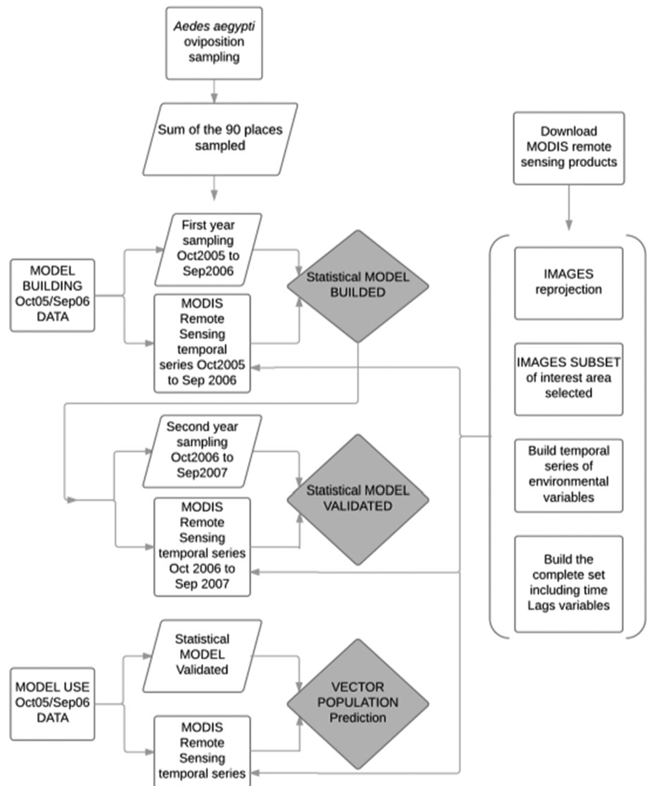 Figure 1: Comparison of variables and time lags used in the linear regression models.
Proving the Concept: The 2016 Outbreak
The true test of any predictive model is a real-world crisis. During the 2015-2016 season, Argentina faced a Dengue outbreak that started "unusually early."
The MODIS-based model (Model 2) captured this shift perfectly. As shown in the comparison below, the model predicted a massive spike in vector activity nearly 60 days earlier than the previous year. This alignment with real clinical notifications validates the model as a viable early-warning tool.
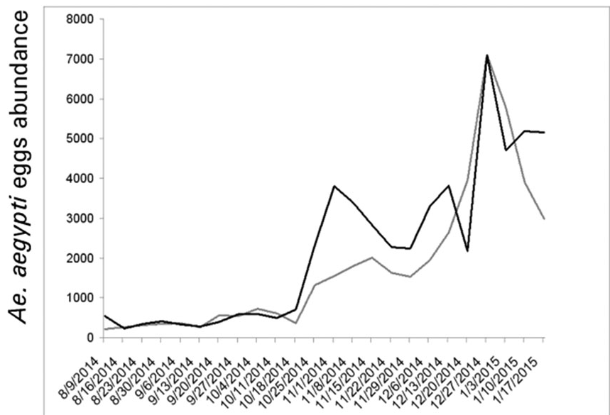 Figure 2: Predicted fluctuations for 2014-2015 (grey) vs the early 2015-2016 outbreak (black).
Critical Insight & Future Outlook
The significance of this work lies in its operational feasibility. While many academic papers focus on increasing spatial resolution, this study prioritizes temporal frequency and data accessibility.
Key Takeaways:
- NDVI as a Rainfall Proxy: The high correlation (0.76) between city-level NDVI and egg counts confirms that satellite-derived greenness is a reliable indicator of the "moisture-plus-warmth" recipe mosquitoes need.
- National Scale Potential: Because MODIS data is free and covers the entire globe daily, this model can be replicated across different latitudes without the need for 200+ individual sensor calibrations required by higher-resolution platforms.
Limitations: The study relies on linear regression. While effective, the non-linear nature of climate-disease interactions suggests that future iterations incorporating Deep Learning (e.g., LSTMs) could handle extreme weather anomalies even more robustly.
In conclusion, the marriage of satellite remote sensing and entomology provides a cost-effective "eye in the sky," allowing health authorities to deploy mosquito control teams weeks before the first human case is even reported.