
GF-1 Temporal Extraction: Cracking the Code of Multi-Crop Monitoring in Cloud-Prone Regions
Assessment of Monitoring Regional Cropping System with Temporal Extraction Model Based on GF-1/WFV Imagery
This paper introduces a high-precision temporal extraction model for monitoring regional cropping systems using China's GF-1/WFV satellite imagery. By leveraging 16m resolution NDVI time-series data, the researchers successfully mapped the spatial distribution of "Rice-Winter Wheat" and "Winter Wheat-Summer Maize" systems in Suqian City, achieving an overall classification accuracy of 93.56%.
TL;DR
Researchers have developed a highly accurate (93.56% accuracy) monitoring method for regional cropping systems using China's GF-1/WFV satellite. By analyzing 16m resolution NDVI "signatures" across the full growing season, the model effectively distinguishes between complex rotations like Rice-Winter Wheat and Wheat-Summer Maize, even overcoming the persistent challenge of cloud cover in southern China.
Background: Beyond Single-Crop Mapping
Accurate agricultural monitoring is the backbone of food security. While remote sensing has long been used to identify single crops (like "where is the wheat?"), modern precision agriculture requires understanding cropping systems (the sequence of crops on the same land over a year).
The difficulty lies in two areas:
- Spatial-Temporal Trade-offs: High resolution often comes with low revisit frequency.
- Climate Interference: In the Yangtze River basin, persistent cloud and rain often "blind" satellites during critical growth stages.
The "Temporal Signature" Insight
The core philosophy of this paper is that every cropping system has a unique "biological heartbeat" or NDVI time-series curve. By selecting 10 specific dates of GF-1 imagery, the authors reconstructed these heartbeats.
- The Rice vs. Maize Challenge: Both crops grow in the summer and look similar in August. However, the researchers found a "critical window": in late October, maize NDVI drops sharply as it matures, while rice maintains a higher NDVI. This temporal divergence is the key to their classification accuracy.
Methodology: High-Density Temporal Modeling
The team utilized the 4-day revisit period of the GF-1/WFV sensors to ensure they had enough "clear" pixels.
1. Model Architecture & Flow
The workflow involves rigorous preprocessing (radiometric and atmospheric correction) followed by a Spatial Superposition Decision Method. The model doesn't just look at one image; it treats the entire year as a logical sequence of "If-Then" conditions based on NDVI thresholds.
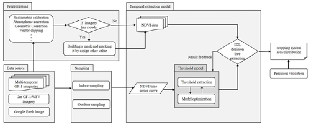 Fig 1: The methodical flow from imagery preprocessing to the final spatial decision.
2. Solving the Cloud Problem
Instead of discarding cloudy images, the authors created "polluted area masks." By assigning unique tags to these pixels and using multi-temporal supplements, they ensured that data loss in one month could be compensated by the 4-day revisit frequency of other GF-1 sensors.
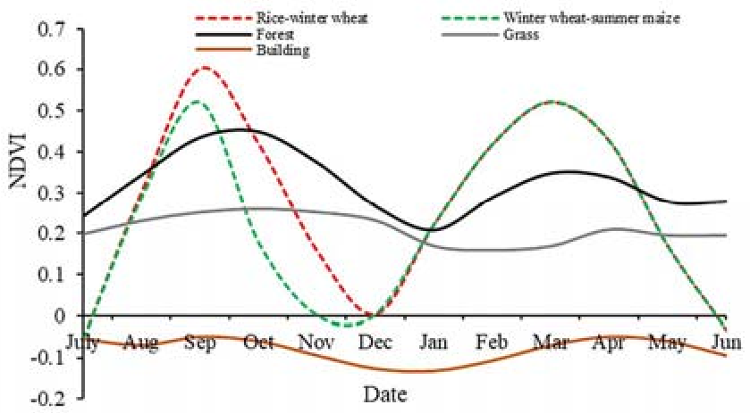 Fig 2: Effective cloud interference reduction through mask building.
Experimental Results: Precision at Scale
The study focused on Suqian City, a typical two-ripening region. The model's results were compared against field samples collected via GPS and high-definition Google Earth imagery.
| Cropping System | Production Accuracy | User Accuracy |
|---|---|---|
| Rice-Winter Wheat | 96.40% | 95.31% |
| Wheat-Summer Maize | 84.03% | 87.39% |
The slightly lower accuracy for Summer Maize is attributed to its "scattered" planting nature compared to the massive, concentrated blocks of Rice-Wheat rotations.
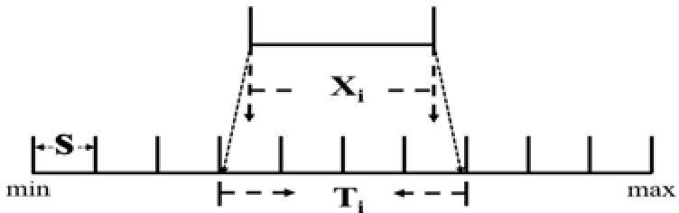 Fig 3: Final spatial distribution map showing the clear demarcation of different agricultural regimes in Suqian.
Critical Insight: The Value of Human-Computer Interaction
Unlike "black-box" AI models, this research emphasizes interactive threshold optimization. By projecting 95% effective NDVI values into density grades, the authors ensured the model remained grounded in physical reality. This makes the system highly interpretable for agricultural policy-makers.
Summary & Future Outlook
This work proves that GF-1/WFV imagery is a formidable tool for regional agricultural management. While the current model excels in flat plains with clear rotations, the next frontier is complex terrains (like the hills of Hunan) where mixed pixels become a dominant issue.
Future directions suggested by the authors include integrating texture features and morphological characteristics to further refine the model's ability to distinguish between even more similar crop varieties.