
Beyond the Gush: Harnessing Multidimensional Ontology for Petroleum Digital Ecosystems
Multidimensional ontology modelling — A robust methodology for managing complex and heterogeneous petroleum digital ecosystems
This paper introduces a robust methodology for managing complex, heterogeneous petroleum digital ecosystems using Multidimensional Ontology and the Classified Interacted Dimension Model (CIDM). By integrating domain ontologies into a data warehousing framework, the authors achieved structured metadata generation and decision support through SOTA data mining techniques like decision trees and cluster analysis.
Executive Summary
TL;DR: Managing data in the petroleum industry is as challenging as the drilling itself, characterized by high-dimensional heterogeneity and fragmented archives. This paper presents a specialized framework using Classified Interacted Dimension Models (CIDM) and integrated ontologies to structure this data into a "warehoused metadata" environment. By moving beyond traditional flat data models, the research enables advanced data mining—specifically decision trees and cluster analysis—to predict oil-bearing "plays" and visualize reservoir patterns with high precision.
Positioning: This work serves as a foundational methodology for Petroleum Digital Ecosystems, bridging the gap between raw geological data and high-level strategic decision-making.
The Bottleneck: Why Petroleum Data is "Hard"
In the resources sector, data isn't just "big"; it's multidimensional and inconsistent. Information regarding sedimentary basins, tectonic settings, and seismic results often exists in silos. Conventional Entity-Relationship (ER) models fail here because they lack the abstraction needed to handle the complex spatio-temporal relationships inherent in petroleum systems. The result? Ambiguities, data redundancy, and a "knowledge gap" where valuable insights remain buried in under-utilized archives.
Methodology: The CIDM Framework
The researchers' core innovation lies in the use of Multidimensional Ontology. Unlike a standard database schema, an ontology standardizes the conceptual vocabulary (e.g., distinguishing a "Source" from a "Reservoir" and defining their interaction).
1. Architectural Representation
The Classified Interacted Dimension Model (CIDM) treats dimensions as objects that communicate. It uses hierarchies (Super-types and Sub-types) to represent geological artifacts. For instance, a "Reservoir" class might branch into "Carbonates" or "Sandstones," each inheriting specific physical attributes like porosity or permeability.
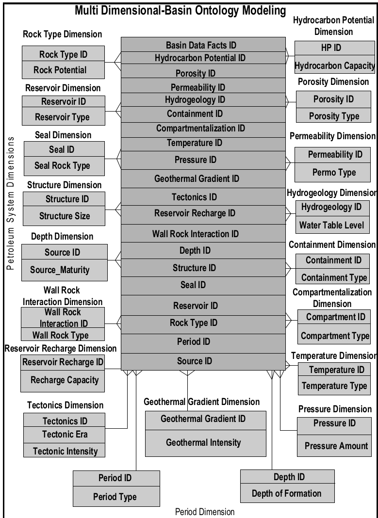 Figure 1: The multidimensional ontology model showing the transition from conceptual dimensions to a star-schema metadata structure.
2. Integration and Warehousing
The methodology moves from conceptual ontology to physical implementation. By mapping these ontologies into a data warehouse environment (Oracle), the system can generate "Data Cubes." These cubes allow analysts to "slice and dice" data across dimensions like time, geography, and geological age.
Experiments and Results: Striking Wisdom
The authors applied their framework to actual petroleum basin data, utilizing two primary mining schemes:
A. Decision Tree Mining
By characterizing numerical (porosity) and categorical (play type) attributes, the system generated rule-based classifiers.
- Result: The classification rules achieved an accuracy of 70% in identifying successful reservoir plays based on kerogen and porosity levels.
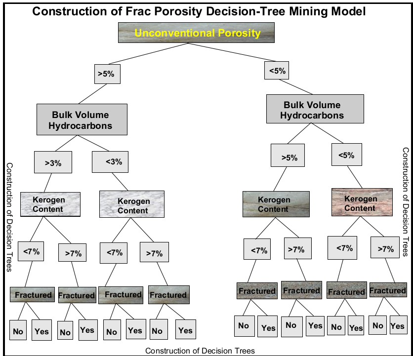 Figure 2: The construction of decision tree models for classifying shale play favorability.
B. Cluster Mining (Geographical Visualization)
The system analyzed structural and reservoir anomalies across geographic coordinates.
- Result: The framework successfully generated "bubble" plots where bubble size corresponds to reservoir density. This allowed for the visual identification of "sweet spots" (dense clusters) for exploration.
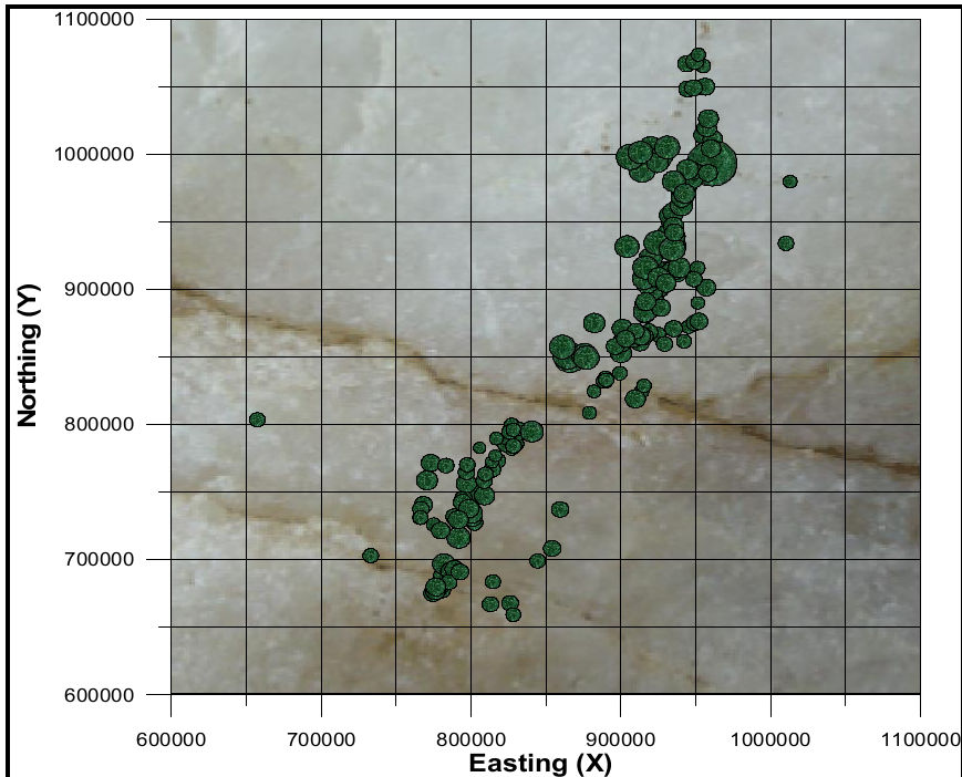 Figure 3: Clusters of structural anomalies used for qualitative interpretation of petroleum-bearing regions.
Critical Insight & Future Outlook
The true value of this methodology is its robustness. By providing a "Shared Ontology," it allows different operational units to speak the same language. However, a notable limitation is the reliance on manual class-attribute mapping, which could be improved through automated machine learning-based ontology matching.
Conclusion: As the industry moves toward "Digital Oil Fields," the CIDM approach provides a crucial structural spine. Future work will likely see these ontologies integrated with Semantic Web (OWL) standards, allowing for global interoperability across different petroleum ecosystems and even greater automation in knowledge discovery.