
Beyond the Visible: Mastering Road Attribute Detection via Pixel-Level Multimodal Fusion
Multimodal Fusion of Satellite Images and Crowdsourced GPS Traces for Robust Road Aribute Detection
The paper introduces a multimodal fusion framework for automatic road attribute detection (e.g., speed limits, lane counts) by combining high-resolution satellite imagery with crowdsourced GPS traces. The core innovation is a "GPS Rendering" technique that converts raw sequences of location, bearing, and speed into multi-channel images, achieving state-of-the-art accuracy across four major road attributes.
TL;DR
Enriching digital maps is traditionally a labor-intensive manual task. This paper presents a breakthrough multimodal framework that fuses satellite imagery with crowdsourced GPS traces. By rendering noisy GPS data into spatially aligned "images," the authors leverage CNNs to detect road attributes like speed limits and lane counts with unprecedented accuracy (up to 91.4%), effectively solving the invisibility problem of satellite-only methods and the noise sensitivity of GPS-only methods.
The "Invisibility" and "Noise" Dilemma
In the quest for perfect digital maps, researchers have faced a binary struggle. Satellite images provide great spatial context but are blind to "hidden" attributes like speed limits or one-way restrictions. Conversely, GPS traces contain the "behavioral DN" of the road but are notoriously noisy and sparse, often requiring a brittle process called Map Matching to function.
The authors identify a critical insight: Prior work failed because it treated GPS and Images as different species. GPS was treated as a 1D sequence, while satellite data was a 2D grid. This paper bridges that gap by transforming GPS into the language of computer vision.
Methodology: Rendering GPS as a Vision Task
The core of the paper is the GPS Rendering Algorithm. Instead of matching a coordinate to a road, the system projects GPS points onto a 224x224 grid that aligns perfectly with a satellite tile.
1. Multi-Channel Encodings
The "image" created from GPS isn't just a heatmap. It consists of multiple channels:
- Location Channel (): Density of GPS points.
- Bearing Channels (): A histogram of movement directions at every pixel.
- Speed Channels (): A histogram of vehicle speeds at every pixel.
2. Temporal 3D Fusion
Since traffic patterns change (e.g., peak hour speeds vary), the authors utilize 3D GPS Rendering. They slice GPS data into time bins and process them through a Bi-directional GRU to capture temporal dynamics, effectively treating the sequence of GPS images like a video.
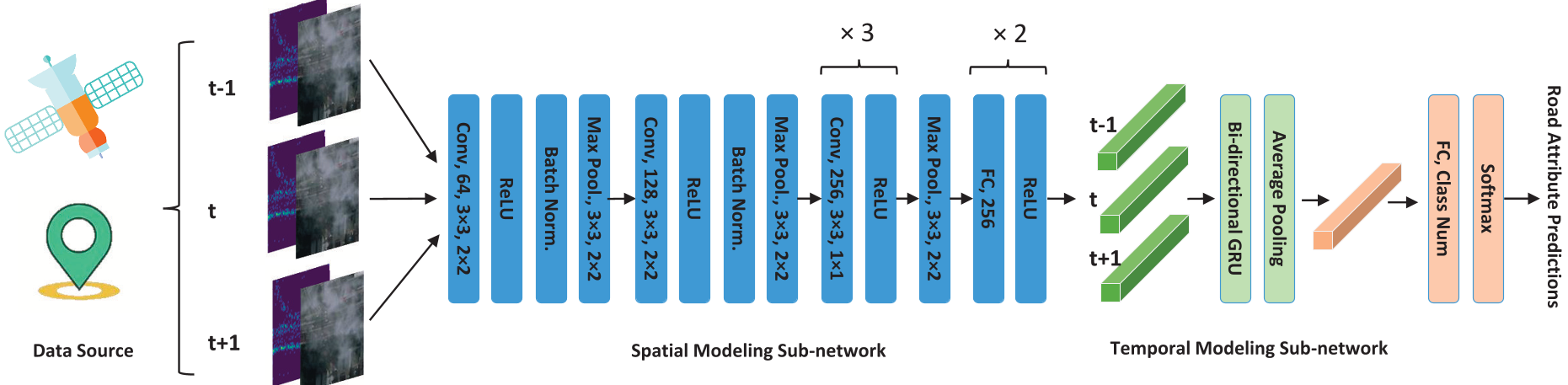 Figure 1: The proposed multimodal network architecture featuring spatial and temporal sub-networks.
Experiments: Dominating the Baselines
The framework was tested in Singapore and Jakarta—two cities with vastly different data densities.
- Robustness to Occlusion: When clouds block a satellite view, the GPS channels provide the missing logic of the road's flow.
- Feature Synergy: While satellite images are better at identifying "Residential" areas (due to surrounding buildings), GPS data is significantly superior at identifying "Primary" roads where traffic flow is high and speed patterns are distinct.
 Table 1: Competitive analysis showing our Fusion-3D model outperforming single-modal and SOTA methods across all attributes.
Critical Insight: The Power of Calibration
One of the paper's subtle but vital contributions is Road Direction Calibration. By rotating images and adjusting bearing values relative to the road's axis, the model gains Inductive Bias. It stops caring about "North vs. South" and starts caring about "Along the road vs. Across the road," which is far more relevant for lane and one-way detection.
Future Outlook and Limitations
While the method is highly robust, it still faces challenges with rare classes (e.g., 90 km/h speed limits) due to data imbalance. Future iterations could integrate more modalities, such as dash-cam footage or vehicle accelerometers, to further refine the "behavioral signature" of the road.
Conclusion
This work demonstrates that the best way to solve complex geographic problems isn't just "more data," but "better-aligned data." By treating GPS trajectories as a visual modality, the authors have unlocked a powerful way to keep our global maps accurate, safe, and autonomous-ready.