
MyTrace: Deciphering the Digital Footprints of Modern Tourists
MyTrace: A Mobile Phone-Based Tourist Spatial-Temporal Behavior Record and Analysis System
This paper introduces MyTrace, an open research-oriented system designed to record and analyze the spatial-temporal behavior of tourists using mobile smartphones. By integrating a mobile app, a data receiver, and a web-based analysis platform, the system achieves SOTA-level precision in tracking individual trajectories, successfully constructing a dataset of over 188,000 GPS locations from 659 registered users.
TL;DR
MyTrace is a sophisticated mobile-based system designed to replace traditional travel diaries with high-precision GPS tracking and real-time activity logging. It bridges the gap between raw spatial data and human intention, providing researchers with a rich dataset of over 188,000 GPS points to analyze tourist dynamics and improve destination planning.
Background: Beyond the Static Survey
Historically, understanding Tourist Spatial-Temporal Behavior was a manual, error-prone task. Researchers relied on questionnaires where tourists had to recall their movements days after the fact. With the advent of the "Digital Trace" era, we began using Flickr photos or mobile network events to track crowds. However, these methods are "blind" to the why—why did a tourist stop here? How did they feel? MyTrace addresses this by creating a closed-loop system where location data meets subjective user feedback.
The Core Architecture: From Raw GPS to Semantic Insights
The system is built on a robust three-tier architecture:
- Mobile Application (Android/iOS): The frontline sensor capturing GPS data every 10 seconds.
- Data Receiver: The bridge that handles asynchronous data uploads and manages file systems for media.
- Web-Based Platform: The command center for researchers to design questionnaires, export logs, and visualize trajectories.
Mathematical Modeling of Human Movement
The paper defines three critical data layers:
- Location Log: Simple ordered pairs of .
- Stop Point: A spatial-temporal cluster where a user spends a duration within a distance .
- Activity Point: The "Holy Grail" of the data—a GPS point enriched with user-labeled remarks, photos, and social context (e.g., traveling with family vs. friends).
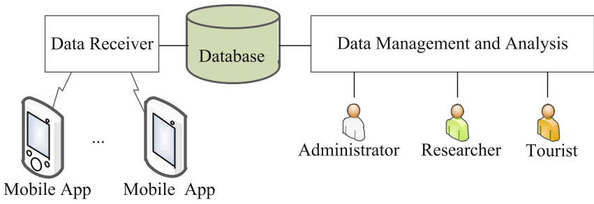 Figure 1: The Network Structure of the MyTrace System.
Methodology: Balancing Precision and Battery Life
One of the primary technical hurdles in mobile tracking is battery drain. MyTrace utilizes an accelerometer-based trigger to detect stationary periods, suspending the power-hungry GPS chip when the user isn't moving. By setting a 10s interval, the system captures fine-grained movements within a tourist attraction, which is a significant improvement over the sparse data provided by cellular tower triangulation.
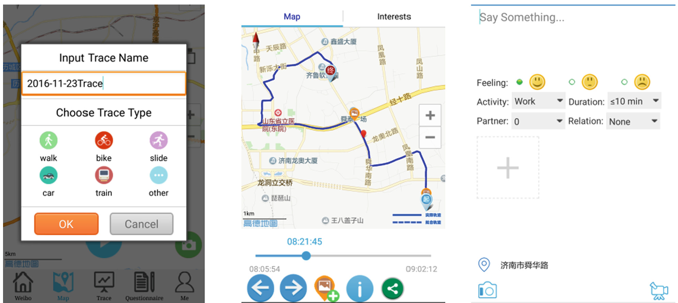 Figure 2: User Interfaces for Trace Recording and Activity Marking.
Experimental Insights: Who is the Modern Traveler?
The trial operation in 2016-2017 yielded fascinating demographic insights:
- The Demographic Tilt: Nearly 2/3 of users were students, highlighting a tech-savvy younger generation as the primary source of digital footprints.
- Temporal Patterns: Analysis of "Time Events" revealed that taking pictures peaks at noon (likely due to lighting and lunch stops), while communication (calls/texts) peaks during transit periods in the morning and afternoon.
- Destinational Differences: By comparing two attractions (Shenzhen vs. Huizhou), the authors found that certain locations attract "repeat leisuists" while others attract "one-time sightseers."
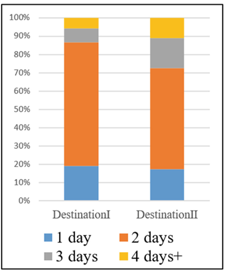 Figure 3: Multi-dimensional comparison of tourist responses between attractions.
Critical Analysis & Conclusion
MyTrace represents a successful transition from "Passive Sensing" to "Participatory Sensing." By allowing users to share their traces on social networks like WeChat, the system incentivizes data collection, turning a research task into a social experience.
Limitations: The current reliance on manual user labels (Activity Points) means the data is only as good as the user's willingness to tag. Future iterations could benefit from automated activity recognition (e.g., using GIS data to automatically tag a 30-minute stop at a restaurant as a "Dining Event").
Future Outlook: Systems like MyTrace are the precursors to Personalized Recommendation Engines for tourism. By understanding the granular "stop-and-go" patterns of specific demographics, future cities can optimize crowd control and design more intuitive landscape layouts.