
Geo-Ontology: The Semantic Bridge for Distributed GIS Networks
Using ontology to achieve the semantic integration and interoperation of GIS
This paper explores the use of Geo-Ontology to resolve semantic heterogeneity in Distributed Geography Information Systems (GIS). It proposes a hybrid architecture combining local ontologies with a global shared vocabulary and introduces an LDAP-based resource management system to achieve seamless semantic interoperability across spatial information grids.
TL;DR
In the era of networked information, Geography Information Systems (GIS) suffer from data fragmentation. This paper presents a Hybrid Geo-Ontology framework that utilizes both expert knowledge and data mining to reconcile semantic differences. By pairing this ontology with LDAP (Lightweight Directory Access Protocol), the authors create a "Transparent Spatial Information Grid" where distributed data sources speak the same conceptual language.
The Challenge: Why GIS Interoperability is Hard
Integrating spatial data isn't just about connecting cables; it's about aligning meanings.
- The Granularity Gap: One system might define a "Wetland" broadly, while another breaks it down into "Marshes" and "Swamps."
- The Vocabulary Clash: Different organizations use different terms for the same spatial features, leading to failed queries in distributed environments.
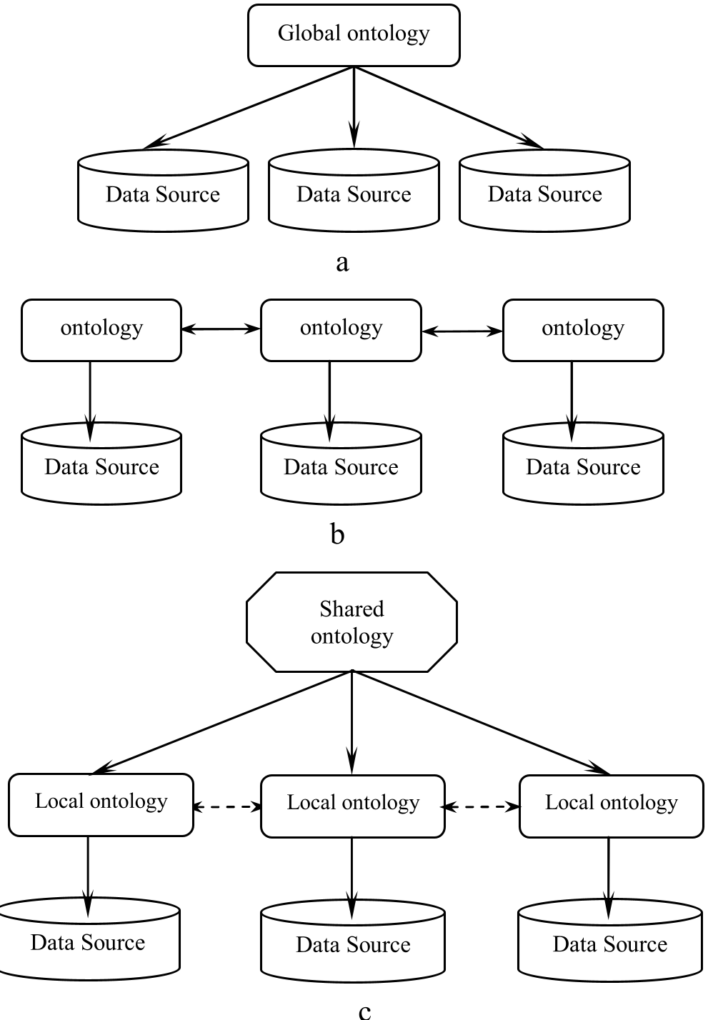
The paper argues that previous attempts—using a single global ontology or disconnected multiple ontologies—either lacked flexibility or failed to provide a common ground for comparison.
Methodology: The Hybrid Path to Semantic Fusion
The core innovation lies in a two-pronged approach to building the "Geo-Ontology."
1. Three-Tier Ontology Architecture
The paper adopts a hybrid architecture to balance flexibility and standardization:
- Shared Vocabulary: A set of "atomic" concepts (primitives) that everyone agrees on.
- Local Ontologies: Specific mappings that describe each unique source using the shared primitives.
2. Semi-Automatic Ontology Construction
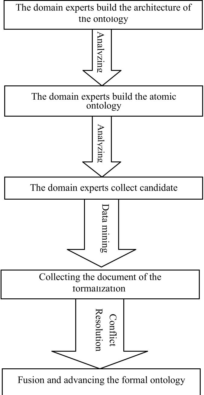
Instead of relying solely on slow human expertise, the authors suggest:
- Expert Oversight: Experts build the initial concept tree and define "atomic" ontologies.
- Data Mining (Attribute Correlation): Using algorithms to analyze GIS data attributes and automatically filter the most significant features for the ontology.
Implementation: The Spatial Information Grid
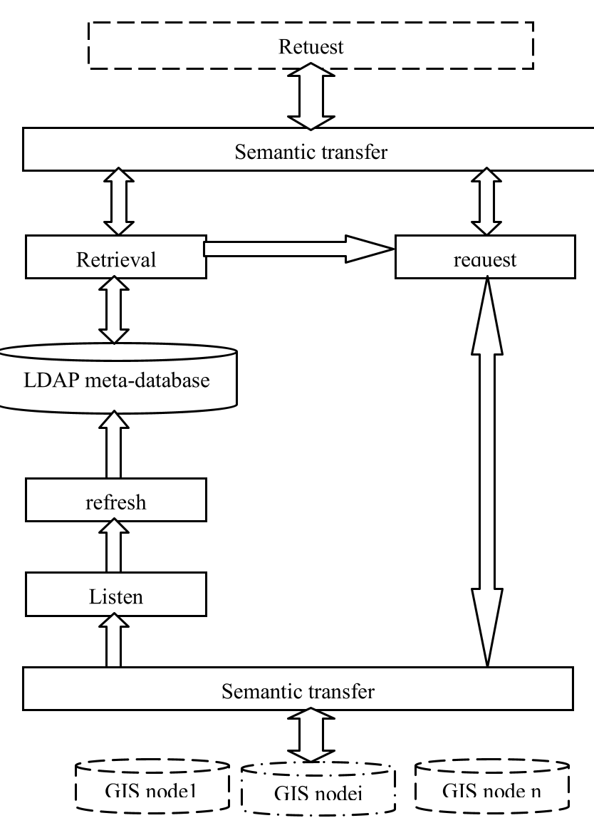
To make this theory practical, the paper introduces a resource management system based on LDAP.
Why LDAP? It acts as the backbone for a Virtual Organization. By storing ontological metadata in an LDAP directory, the system can perform "Semantic Retrieval." When a user searches for data, the system doesn't just look for keywords; it uses the ontology to understand the meaning of the request and redirects it to the appropriate remote GIS nodes.
Deep Insight & Conclusion
This work represents an early yet vital step toward the Semantic Web for Geography. The real brilliance is not just in defining concepts, but in the Conflict Resolution and Attributes Fusion stage. By automating the extraction of features through data mining, the authors addressed the scalability bottleneck of manual ontology creation.
Takeaway for Today: While modern systems might use Knowledge Graphs or LLMs for entity linking, the principle of a Hybrid Architecture—balancing local autonomy with a global shared schema—remains the gold standard for robust distributed systems.
Limitations
The paper primarily focuses on the structural and attribute-based alignment. However, it leaves the challenges of Temporal Dynamics (how geographic features change over time) and Complex Spatial Relationships (topology) as areas for further exploration.