
Open GIS: Breaking the Monolith of Environmental Digital Libraries
Open GIS and on-line environmental libraries
This paper introduces the "Open GIS" framework as a solution for integrating geospatial data into Environmental Information Systems (EIS). It proposes an architectural abstraction that moves away from closed, monolithic GIS toward an interoperable, service-oriented model for distributed environmental libraries.
TL;DR
Geospatial data has historically been trapped in proprietary "silos." This paper details the shift toward Open GIS, a framework that treats geographic data as a set of interoperable services rather than static files. By abstracting geodata into a common model, it enables distributed environmental libraries to "fuse" and "analyze" information from globally scattered sources.
The "Island" Problem: Why Traditional GIS Failed the Web
In the mid-90s, as the Web began to weave together global information, Geographic Information Systems remained stubbornly isolated. The author identifies a critical friction:
- Monolithic Architectures: GIS software was built as a closed system where data and processing were tightly coupled.
- Heterogeneity: Environmental data includes everything from soil maps to satellite imagery. Translating between these formats via "batch conversion" was slow and error-prone.
- Scale: Distributed users needed to find data, evaluate its suitability (metadata), and access it without owning the specific software that created it.
Methodology: The Open GIS Abstraction
The core innovation discussed is the Open Geodata Model (OGM). Instead of defining how data is stored on a disk, Open GIS defines how data behaves.
The Layered Abstraction
The paper describes a 9-layer abstraction process that translates the "Real World" into the "Project World." This ensures that whether you are looking at a discrete object (like a building) or a continuous phenomenon (like temperature), the interface for querying them remains consistent.
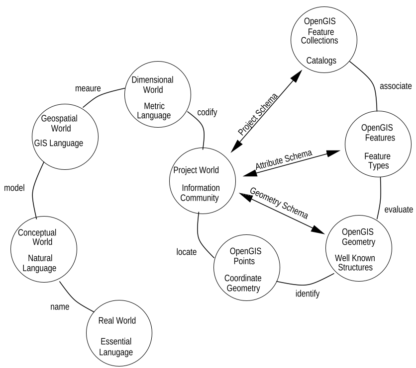 Figure 1: The Open GIS Abstract Model, showing the path from real-world essence to Feature Collection.
The Geodata Class Hierarchy
The OGM treats geography as a type hierarchy. By decomposing datasets into spatial, semantic, and metadata components, the system allows for Interoperability. This means a user can perform a "spatial intersect" operation without needing to know if the underlying data is stored in a vector format or a raster grid.
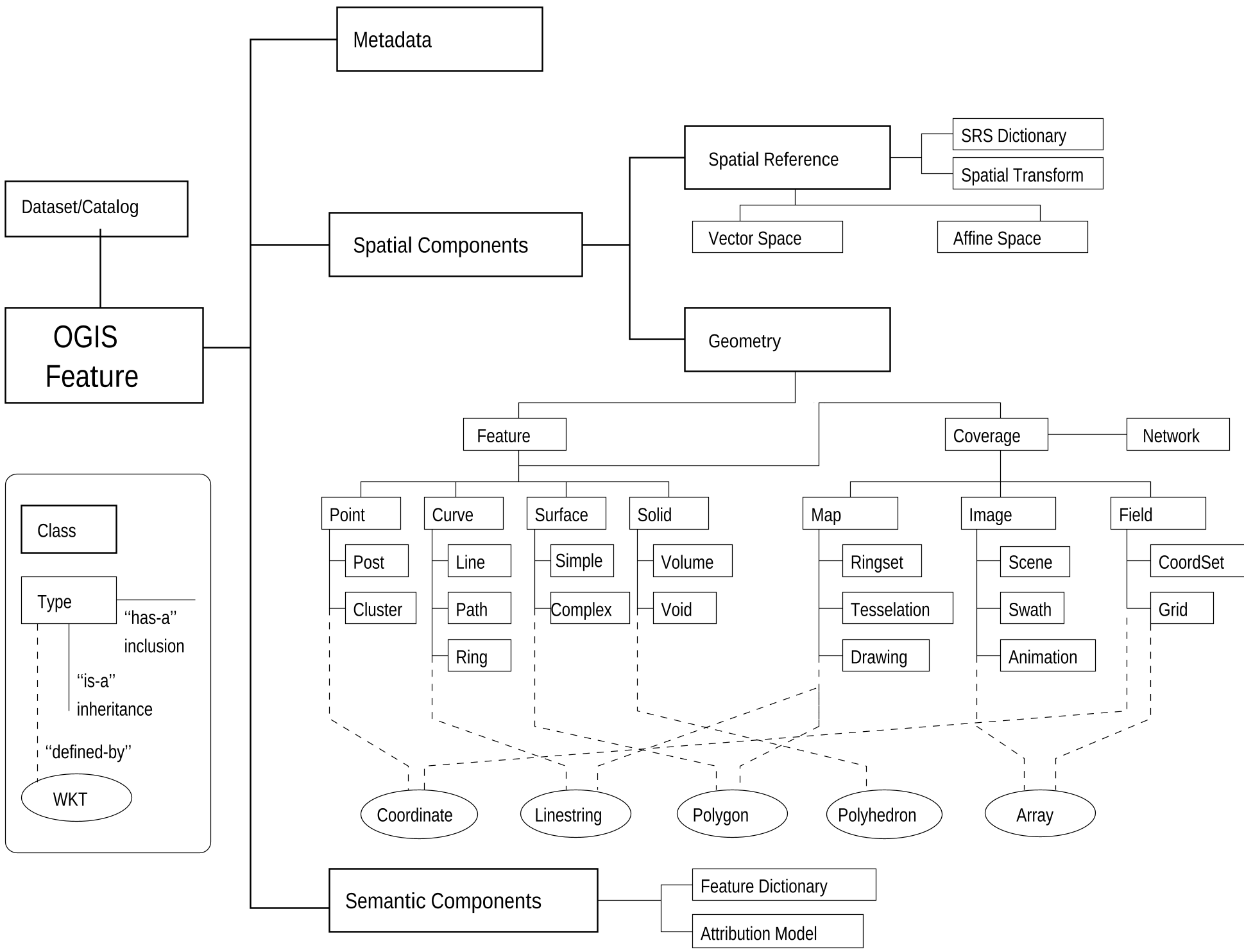 Figure 2: The Open Geodata Model hierarchy, separating features from their metadata and spatial reference.
Architecture of an Open EIS
The author proposes a functional flow for an Open Environmental Information System (EIS). Rather than a single "engine," the system is composed of specialized components:
- Atomizer: Pulls specific, atomic elements (like a single polygon) from a large repository instead of downloading a 500MB dataset.
- Fuser: Handles the "semantic translation" and coordinate transformations required to make two different datasets talk to each other.
- Analyzer: Performs "Map Algebra" (buffering, spatial joins) in a distributed environment.
- Viewer: The intelligent interface that translates human questions into structured "Open GIS" queries.
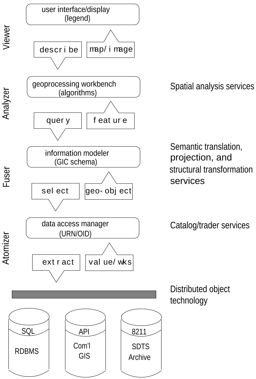 Figure 3: The conceptual flow of an Open Environmental Information System.
Deep Insight: Interfaces Over Structures
The most profound takeaway from Gardels' work is the "Interface Orientation." By defining Well Known Structures (like a simple sequence of X,Y coordinates), Open GIS allows a legacy database to "wrap" itself in an Open GIS interface. To the end-user, the legacy database looks and acts just like a modern digital library.
Conclusion and Future Outlook
This paper laid the groundwork for the modern "Geospatial Web." While today we take for granted things like Google Maps or web-based GIS, the rigorous abstraction of the Open GIS specification was what allowed these heterogeneous systems to eventually speak a common language.
Limitations noted: The paper admits that while geodata access was becoming standardized, the standardization of analytical functions (the "Analyzer" component) was still in its infancy in 1996.
Takeaway for Today: As we move into the era of AI and "Digital Twins," the principle of decoupling data from the software engine remains the golden rule for building scalable environmental systems.