
WOA-Crowd: Optimizing Spatial Queries via Whale-Inspired Intelligence
Optimal processing of nearest-neighbor user queries in crowdsourcing based on the whale optimization algorithm
The paper proposes an optimized framework for processing K-Nearest Neighbor (KNN) and Range queries in mobile crowdsourcing environments using the Whale Optimization Algorithm (WOA). It introduces area-based and distance-based "trust stages" to evaluate query answer accuracy and compares the efficiency of serial versus parallel processing modes.
TL;DR
In the world of mobile crowdsourcing, answering "Where is the nearest...?" is surprisingly expensive. This paper introduces a novel approach using the Whale Optimization Algorithm (WOA) to handle K-Nearest Neighbor (KNN) and Range queries. By modeling query selection as a multi-objective optimization problem, the authors achieve a high-reliability "Trust Stage" while minimizing the hidden costs of human-powered data gathering.
Background: The Crowdsourcing Bottleneck
As the Internet of Things (IoT) expands, we increasingly rely on the "wisdom of the crowd" for real-time spatial data. However, crowdsourcing isn't free. Every query sent to a "gang" of mobile users consumes bandwidth (Communication Overhead) and time (Latency).
The core challenge is Optimality: How do we get the most accurate answer (the highest "Trust Stage") without flooding the network or waiting forever for a response?
Methodology: Whales in the Data Stream
The authors rely on the Whale Optimization Algorithm (WOA), a meta-heuristic inspired by humpback whales.
1. The Spatial Search Engine
The system uses a Quad-tree (Space Tree) to index Points of Interest (POI). Regions are divided into quadrants, and nodes are assigned values (0 or 1) based on whether they contain familiar or unfamiliar spatial data.
2. The Whale Optimization Insight
Why whales? WOA excels at balancing Exploration (searching new areas) and Exploitation (narrowing down on the best solution).
- Prey Surrounding: The "whales" (query agents) move toward the best current solution.
- Bubble-Net Attacking: A spiral movement models the refinement of the query to find the most trustworthy spatial data point.
 Figure 1: High-level overview of the crowdsourced query environment.
3. Trust Stage Computation
Accuracy is measured through two metrics:
- Area-based Trust: Ratio of the familiar spatial area to the total query range.
- Distance-based Trust: Proximity of the POI to the query origin relative to the boundaries of known space.
Parallel vs. Serial: A Strategic Choice
The paper provides a deep dive into two processing architectures:
- Parallel Processing: High speed (low latency) but risks high communication overhead due to redundant data from multiple gang members.
- Serial Processing: Information passes from one member to another (like a relay). This dramatically reduces message overhead but increases the total time taken to reach the final answer.
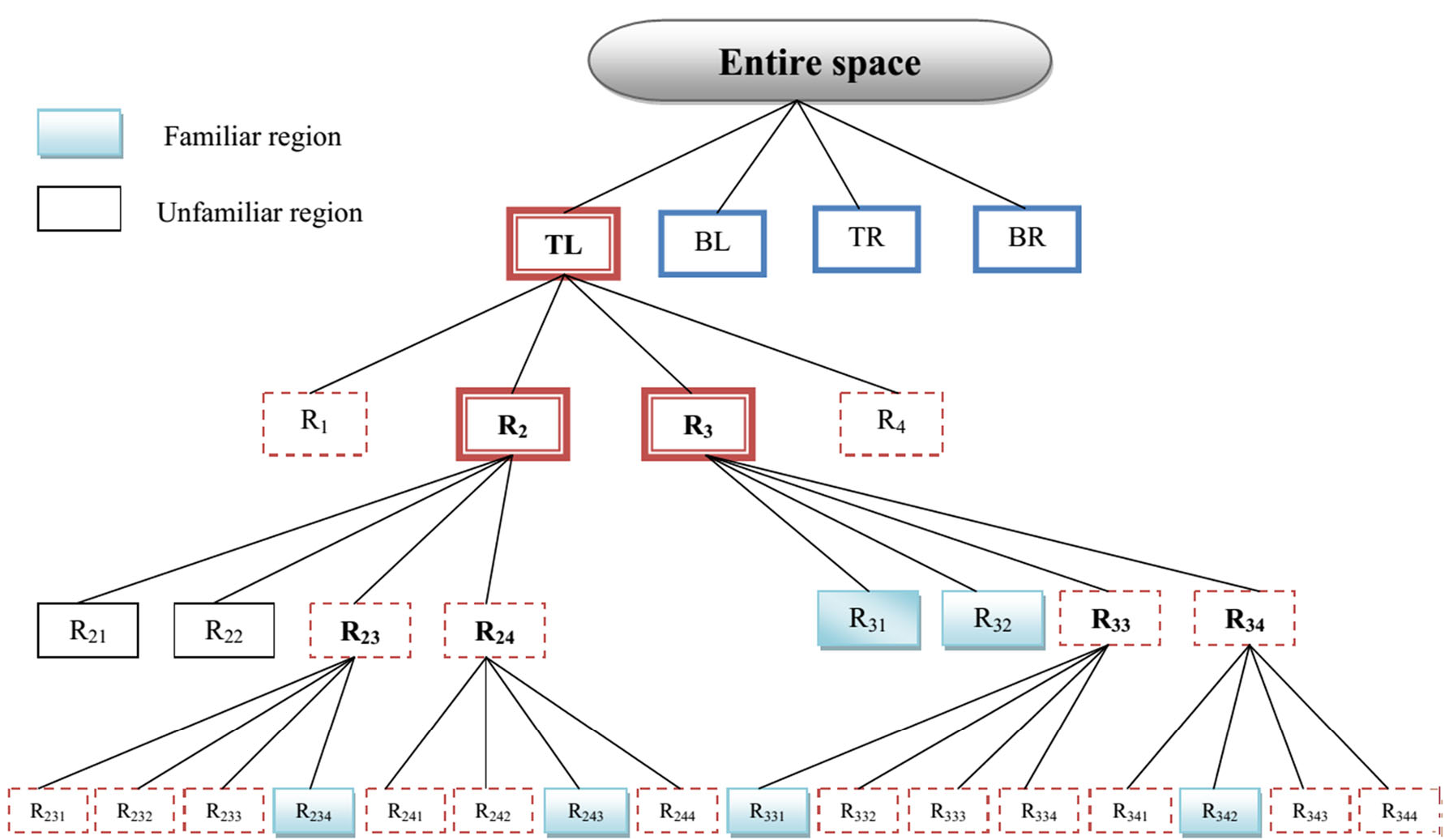 Figure 2: The hierarchal Quad-tree structure used for spatial indexing.
Experimental Results
Using the California POI dataset, the authors tested various "consequences" (parameters):
- Gang Size: As gang members increase, serial processing maintains a much flatter growth curve for communication overhead compared to parallel processing.
- POI & Space Info: Increasing the density of known spatial data naturally boosts the "Trust Stage," proving the model's sensitivity to data quality.
- Efficiency: The WOA-based optimizer successfully found query paths that minimized monetary costs while keeping trust levels above acceptable thresholds.
Critical Analysis & Future Outlook
Takeaway: This work represents a significant step in marrying nature-inspired heuristics with database management. By treating query selection as an optimization problem rather than a simple retrieval task, the authors provide a more robust framework for real-world IoT applications.
Limitations: While the results are promising, the current model assumes a relatively static gang. In high-mobility scenarios (e.g., fast-moving vehicles), the quad-tree might require frequent, expensive updates.
Future Work: The authors suggest moving toward a MapReduce framework to handle massive, planetary-scale datasets, which could make this whale-inspired logic the backbone of future global navigation and service apps.
Keywords: Crowdsourcing, Whale Optimization Algorithm, KNN Query, Spatial Databases, Trust Computation.