
Out on the Town: Bridging the Gap Between the Built Environment and Digital Guides
Out on the town: A socio-physical approach to the design of a context-aware urban guide
The paper introduces a multidisciplinary "socio-physical" approach to designing context-aware urban guides. It synthesizes architecture, sociology, and HCI to create the "Just-for-Us" mobile system for Federation Square, Melbourne, demonstrating how digital layers can be grounded in the physical and social realities of urban life.
TL;DR
Mobile urban guides often feel like outsiders—digital overlays that don't quite understand the "vibe" or the layout of the city. This paper introduces a socio-physical approach, blending architecture and sociology to build a context-aware system called Just-for-Us. By shifting the focus from "Where is the user?" (GPS) to "What is this place and who is here?" (Socio-Physical Context), the authors demonstrate a blueprint for truly situated pervasive computing.
The Motivation: The "Blindness" of Current Guides
Most context-aware systems suffer from a form of technological myopia. They know your longitude and latitude, but they don't know that you are standing in front of a landmark you visited last week with your friends, or that you prefer to avoid crowds when it's sunny. The authors argue that urban spaces are hybrid environments consisting of three layers:
- Physical: The bricks, paths, and landmarks.
- Social: The crowds, meetings, and shared histories.
- Digital: The information pushed to our devices.
The pain point? Designers often fail to create a "fit" between the digital layer and the existing socio-physical fabric, resulting in systems that are ignored or obstructive.
Methodology: The PIA and SOPHIA Frameworks
The core contribution of this work is a multidisciplinary methodology that provides "design traction" for urban interaction.
1. Physical Interaction Abstraction (PIA)
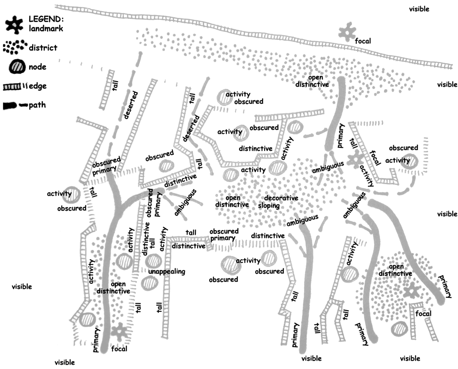
Drawing from legendary urban planner Kevin Lynch and architect Christopher Alexander, the authors created PIA. It maps the city not just as a 2D plot, but as a collection of Paths, Edges, Districts, Nodes, and Landmarks.
- The Insight: People don't think in "meters"; they think in "districts." The system should reflect this by organizing information around architectural focal points.
2. Social Physical Interaction Analysis (SOPHIA)
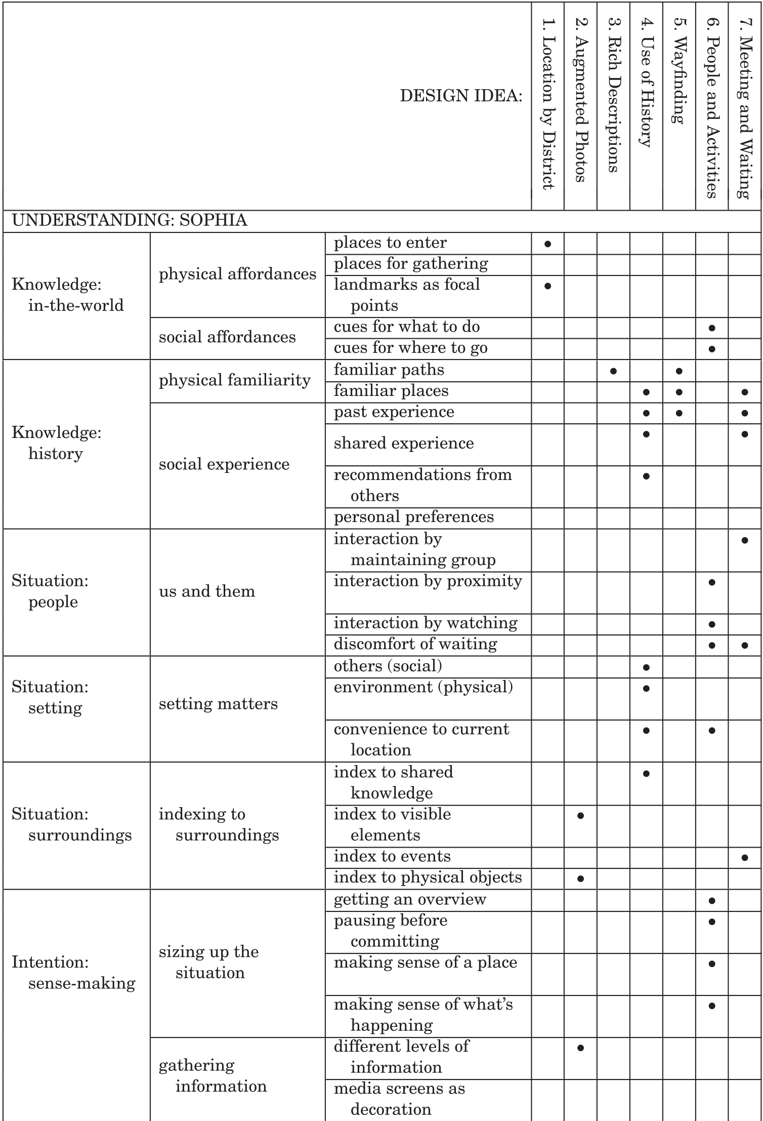
Through rapid ethnography and grounded theory, the authors identified that social context is driven by Knowledge (History), Situation (People), and Intention (Sense-making).
- The Insight: Users use "social affordances." If they see a queue, they assume something interesting is there. If they are with a specific group of friends, they want to go where they "usually meet."
Methodology into Practice: The "Just-for-Us" Prototype
The authors translated their findings into seven key design ideas, creating a system for Melbourne’s Federation Square.
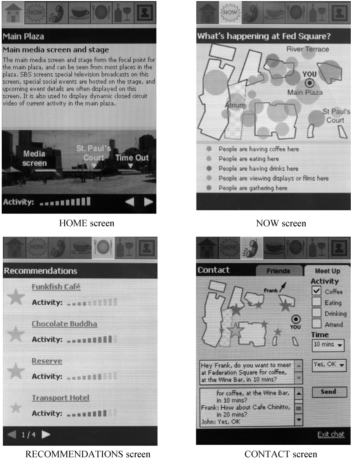
- Augmented Photos: Instead of a flat map, users see panoramic photos of their district. Text overlays show what is inside a building, solving the problem of obscured entrances.
- Social Translucence: The "NOW" screen displays colored circles indicating where people are gathering and what they are doing (e.g., drinking vs. attending an event), allowing users to "sense" the atmosphere beyond their line of sight.
Experiments and Results
The system was evaluated in both a "Wizard of Oz" field study and a laboratory setting.
- Landmarks as Anchors: Users confirmed that landmarks are far more effective for orientation than abstract maps.
- Ambiguity is Okay: Surprisingly, users didn't need high-resolution photos; they preferred abstract line drawings that helped them match the "outline" of the city to their view.
- The Power of History: The "Use of History" feature was a hit, but it came with a caveat—users wanted more control over how the system used their past visits to make recommendations.
Critical Analysis & Conclusion
The value of this study lies in its multidisciplinary rigor. It proves that designing for the city requires us to stop thinking like software engineers and start thinking like architects and sociologists.
Takeaway: The digital layer of a city shouldn't replace the physical or social layers; it should amplify them. Limitation: The study was localized to Federation Square. While the method (PIA/SOPHIA) is generalizable, the specific design ideas are highly dependent on the "vibe" of the specific urban location.
For developers of future LLM-integrated urban guides or AR experiences, this paper serves as a reminder: Context is not just a GPS coordinate; it is a shared story between people and the places they inhabit.